Situation Summary
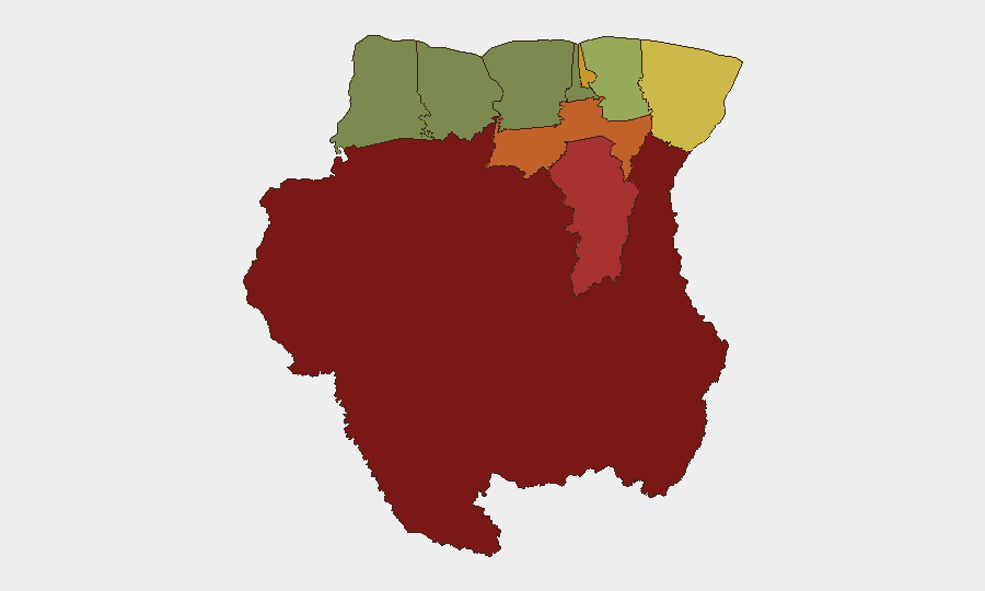
Suriname remains a low-frequency threat environment globally (composite score 12), with no confirmed acute security incidents reported in the last 24–48 hours. However, sub-national risk is heavily concentrated in the interior and eastern border regions, particularly Sipaliwini district (risk 92), reflecting persistent challenges linked to illegal mining, narcotics trafficking, and limited state presence. The capital and surrounding coastal areas remain relatively stable, though organized crime and petty violence remain endemic. A public statement concerning Brazil–Suriname relations was flagged on 22 June; context and specifics are under review.
Key Developments
- Brazil–Suriname Relations Statement (22 June, location/scope TBD). A public statement issued on 22 June involving Brazil and Suriname. Open sources have not yet provided sufficient detail to confirm the nature, location, or operational impact of this communication. Continued monitoring recommended.
- No corroborated acute security incidents in last 48 hours. Web research, news aggregators, and social media monitoring for 20–22 June identified no confirmed reports of large-scale protests, armed clashes, infrastructure failures, or sudden crime spikes with verifiable timestamps and multi-source corroboration in Suriname proper.
- Baseline crime and disorder ongoing in high-risk districts. Petty crime, theft, and gang activity remain persistent in Paramaribo and Brokopondo; no specific recent incident meets threshold for inclusion, but routine vigilance is warranted in these areas.
Highest-Risk Areas
Interior and border districts drive Suriname's sub-national threat profile. Sipaliwini (risk 92) and Brokopondo (risk 78)—both sparsely populated, remote, and resource-extraction zones—host illegal small-scale gold mining operations, drug transshipment networks, and minimal police/military coverage, creating ungoverned space attractive to organized crime and armed groups. Para (74) and Paramaribo (71) reflect urban crime, property theft, and gang activity, though Paramaribo's institutional presence and tourism infrastructure provide some deterrent. Eastern border areas (Marowijne, risk 68) carry trafficking and smuggling risk due to proximity to French Guiana and Brazil. Coastal and western districts (Commewijne, Wanica, Saramacca, Nickerie) present substantially lower risk, supported by stronger state presence and economic activity.
How GeoBit Would Assist
Corporate security teams with personnel or assets in Suriname should deploy AOI Monitoring & Early Warning on Sipaliwini and Brokopondo to detect emerging incidents (protests, armed activity, infrastructure disruption) with low latency. OSINT fusion and corroboration (multi-language news, social media, and local-source integration) will filter signal from noise, avoiding false alerts while capturing credible threats. Network & Actor Analysis focused on trafficking and organized-crime nodes in border and mining zones will inform duty-of-care assessments and supply-chain security. Periodic Conflict & Risk Assessment updates keyed to Brazil–Suriname bilateral developments will flag geopolitical escalation that could affect operations.
7-Day Outlook
Suriname is expected to remain stable over the next week absent rapid escalation of the Brazil–Suriname statement flagged on 22 June. Interior trafficking and mining-zone disorder will persist at baseline levels. Continued monitoring of bilateral regional relations and coastal urban crime patterns is warranted; no imminent mass-casualty or infrastructure-disruptive events are currently signaled.
Highest-Risk Areas — Ranked
| # | State / Region | Risk |
|---|---|---|
| 1 | Sipaliwini | 92 |
| 2 | Brokopondo | 78 |
| 3 | Para | 74 |
| 4 | Paramaribo | 71 |
| 5 | Marowijne | 68 |
| 6 | Commewijne | 42 |
| 7 | Wanica | 38 |
| 8 | Saramacca | 29 |
| 9 | Coronie | 12 |
| 10 | Nickerie | 8 |
Previous Daily Briefs
A new Suriname brief is written every day — each with its own risk map and downloadable CSV. Here's the last week; use the calendar to go further back.
📅 Browse every day by calendar →
Highlighted days have a brief. Tap a day for that day's map & analysis, or “csv” for that day's dataset ($5).