Situation Summary
Syria remains fractured across multiple active conflict zones, with civil war as the primary driver of the country's #8 global threat ranking (composite score 100). Recent event signals spanning 4–6 June indicate ongoing friction between state and non-state actors, judicial-financial tensions, and continued small-arms and artillery activity across opposition-held and contested regions. The trajectory remains volatile with no sign of broad de-escalation; localized clashes, checkpoint harassment, and explosive-remnant incidents continue at a steady baseline across the north and east.
Key Developments
- Artillery exchanges near Idlib city (Idlib Governorate, 4–5 June): Opposition-linked monitors reported overnight shelling between regime and opposition forces on western outskirts, with rounds landing near civilian farmland and triggering minor displacement from edge-of-frontline settlements.
- IED strike on security vehicle near al-Busayrah (Deir ez-Zor Governorate, 4–5 June): Real-time X monitors documented detonation against a vehicle linked to de-facto authorities on rural road, with at least two personnel reported injured and subsequent security sweeps initiated.
- Checkpoint gunfire near Tafas (Daraa Governorate, 4 June): Short firefight between unidentified gunmen and checkpoint-affiliated security personnel resulted in at least one checkpoint member wounded; attackers withdrew without broader escalation.
- Sporadic armed confrontation in Suwayda city (Suwayda Governorate, evening 4 June): Small-arms fire linked to a local armed group dispute left one person wounded; situation de-escalated without state intervention or wider clashes.
- Civilian casualty from unexploded ordnance (Aleppo Governorate, 5 June morning): Farmer's tractor triggered ERW or legacy mine west of al-Bab, injuring at least one civilian and damaging equipment—consistent with ongoing explosive-remnant accident patterns in northern governorates.
- Non-official checkpoint harassment (northern Hama Governorate, 4–5 June): Armed group manning secondary-road checkpoint conducted vehicle searches and temporary detentions, highlighting elevated risk on minor routes relative to main roads.
- Government-company disapproval signals and judicial-banking tensions (6 June): Event feeds indicate official disapproval statements between state and private sector, and friction between judicial and financial institutions, signaling administrative or regulatory stress.
Highest-Risk Areas
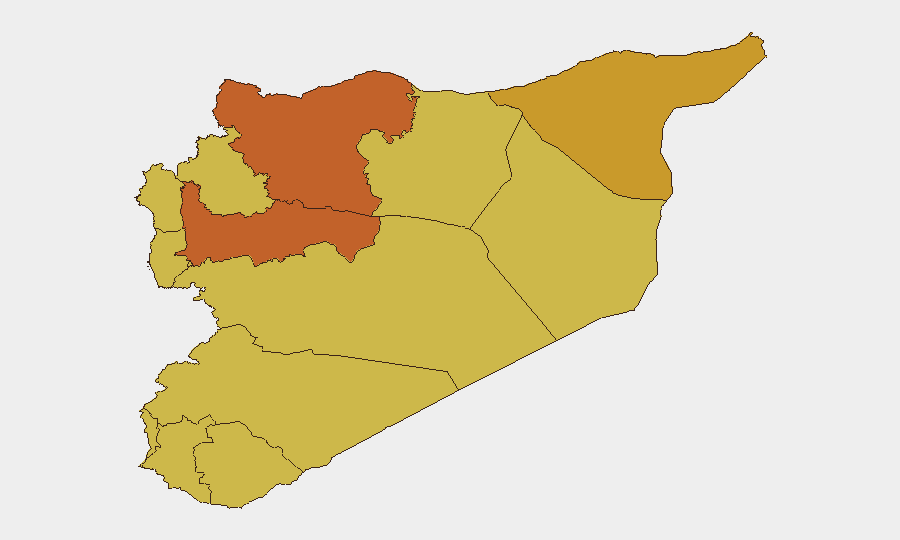
The UNDOF zone (Israeli-Syrian disengagement area, risk 100) and Damascus Governorate (85.5) represent the most acute exposure, driven by active military operations and state security apparatus activity respectively. Hama, Aleppo, and Al-Hasaka Governorates (75–72 risk scores) sustain elevated risk due to ongoing frontline volatility, IED activity, and non-state armed presence. Secondary cities including Daraa, Idleb, and rural Deir ez-Zor, though nominally lower-ranked, continue to record frequent small-scale armed clashes and checkpoint incidents that directly threaten movement and commerce; the persistence of minor-road harassment and roadside explosive remnants underscores that risk extends below major urban and transport corridors.
How GeoBit Would Assist
Security teams would deploy AOI Monitoring & Early Warning on Idlib frontlines, Deir ez-Zor eastern countryside, and secondary-road networks to receive persistent alerts on artillery, IED, and checkpoint activity. OSINT Fusion & Corroboration (convergence of X/Telegram monitors, radio SIGINT, and sentiment analysis) accelerates confirmation of fragmentary real-time reports before mainstream outlets lag days behind. Routing & Network Analysis identifies safer primary-road alternatives and flags secondary routes with documented armed-group presence, enabling safer movement planning for personnel and convoys.
7-Day Outlook
Frontline activity in Idlib and northeastern governorates is expected to remain at steady-state levels absent major military maneuvers. Checkpoint harassment, small-arms incidents, and explosive-remnant accidents will likely continue as baseline security friction; no imminent broad escalation is signaled, but cumulative incident frequency provides recurring exposure to personnel in transit or operating in rural areas.
Highest-Risk Areas — Ranked
| # | State / Region | Risk |
|---|---|---|
| 1 | UNDOF | 100 |
| 2 | Damascus Governorate | 85.5 |
| 3 | Hama Governorate | 75 |
| 4 | Aleppo Governorate | 73.5 |
| 5 | Al-Hasaka Governorate | 72 |
| 6 | Rif Dimashq Governorate | 70.5 |
| 7 | Lattakia Governorate | 70 |
| 8 | Tartus Governorate | 70 |
| 9 | Al-Quneitra Governorate | 70 |
| 10 | Dar'a Governorate | 70 |
| 11 | Idleb Governorate | 70 |
| 12 | Ar-Raqqa Governorate | 70 |
Previous Daily Briefs
A new Syria brief is written every day — each with its own risk map and downloadable CSV. Here's the last week; use the calendar to go further back.
📅 Browse every day by calendar →
Highlighted days have a brief. Tap a day for that day's map & analysis, or “csv” for that day's dataset ($5).