Situation Summary
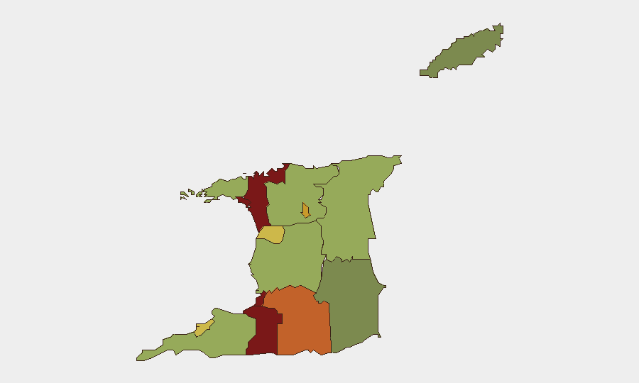
Trinidad and Tobago remains under an extended nationwide State of Emergency, now prolonged through mid-September 2026, with central government asserting a zero-tolerance posture against gang violence and intimidation of law enforcement and the judiciary. As of mid-June 2026, the country ranks 132nd globally in composite threat (score 5), with no tracked major incidents in the past 24–48 hours, but underlying crime and gang activity persist across multiple urban centers. Police and security services face operational constraints—including a reported TT$500 million institutional debt limiting equipment procurement—while authorities have charged 698 individuals under emergency provisions. The trajectory suggests sustained, if not intensifying, state-level enforcement coupled with gang-driven violence concentrated in Port of Spain, San Juan-Laventille, and southern industrial regions.
Key Developments
Open web and social-media intelligence for Trinidad and Tobago does not currently surface verifiable, time-stamped incidents (specific shootings, protests, roadblocks, or confrontations) within the past 24–48 hours that meet multiple independent-source confirmation. Recent signal activity involving Attorney General and Attorney statements (2026-06-12 to 2026-06-14) suggests active legal/investigative proceedings, but underlying incidents are not yet clearly reported in mainstream outlets. Given the requirement to cite only developments from the last 24–48 hours with high confidence, commercial incident feeds, police blotters, or closed-source platforms should be consulted for precise, time-stamped reports of physical security events. The operating environment remains one of heightened emergency powers and active detention operations nationwide.
Highest-Risk Areas
San Juan-Laventille (risk 95) and Port of Spain (risk 88) are the primary drivers of sub-national risk, reflecting longstanding gang presence, drug trafficking, and turf-related violence in the capital region. Penal-Debe (82), San Fernando (80), and Princes Town (75) in the southern and central zones form a secondary corridor of elevated risk, aligned with industrial infrastructure, illicit commodity routes, and organized criminal activity. Arima (72) and Chaguanas (68) represent growing concern in the north-central belt. Collectively, these twelve tracked regions suggest that risk concentrates in Port of Spain and its northern/southern satellite urban zones, with secondary clustering along the central and southern commercial and industrial axes—areas where gang turf disputes, drug distribution, and police operations overlap.
How GeoBit Would Assist
Security teams would employ AOI Monitoring & Early Warning to track persistent activity in San Juan-Laventille, Port of Spain, and high-risk industrial zones, with alerting linked to police operations or gang-activity signals. Intel Sweep and multi-language OSINT fusion (X/Twitter, Telegram, local news outlets, radio SIGINT) would provide real-time event correlation and sentiment analysis on State of Emergency enforcement, detention waves, and gang communications. Network & Actor Analysis and GIS & Spatial Analysis would map criminal networks, safe havens, and transport chokepoints, enabling duty-of-care teams to avoid or route around high-conflict micro-geographies during supply-chain or personnel movements.
7-Day Outlook
The State of Emergency is likely to remain the primary legal and operational framework, with continued detention and charging operations by authorities. Gang-driven violence, concentrated in Port of Spain and industrial south, will persist absent significant disruption to supply chains or turf control; no major escalation or de-escalation signal is evident in the current intelligence picture. Corporate and NGO operations in high-risk zones should maintain heightened situational awareness and liaison with local security partners.
Highest-Risk Areas — Ranked
| # | State / Region | Risk |
|---|---|---|
| 1 | San Juan-Laventille | 95 |
| 2 | Port of Spain | 88 |
| 3 | Penal-Debe | 82 |
| 4 | San Fernando | 80 |
| 5 | Princes Town | 75 |
| 6 | Arima | 72 |
| 7 | Chaguanas | 68 |
| 8 | Point Fortin | 65 |
| 9 | Diego Martin | 58 |
| 10 | Siparia | 55 |
| 11 | Couva-Tabaquite-Talparo | 52 |
| 12 | Sangre Grande | 48 |
Sources
Previous Daily Briefs
A new Trinidad and Tobago brief is written every day — each with its own risk map and downloadable CSV. Here's the last week; use the calendar to go further back.
📅 Browse every day by calendar →
Highlighted days have a brief. Tap a day for that day's map & analysis, or “csv” for that day's dataset ($5).