Situation Summary
Ukraine remains the second-highest threat environment globally, driven by sustained conventional warfare across multiple fronts and a pattern of escalating strike campaigns on both sides. A large-scale Russian missile-and-drone strike on 2 June killed at least 17 people and injured more than 100 across the country, with Kyiv as a primary target, demonstrating the continued lethality of aerial attacks on civilian and military infrastructure. Concurrent Ukrainian strikes on Russian energy assets and rear-area logistics indicate neither side is signaling de-escalation, despite ongoing European diplomacy on security guarantees. The security environment remains kinetic and volatile, with high risk of further aerial bombardment and cross-border strikes.
Key Developments
- Kyiv · 2 June 0200–0400 UTC — Russian overnight missile-and-drone attack killed at least 17, injured 100+; multiple civilian and infrastructure targets struck; air-raid shelters activated; transport and civil-defense disruption ongoing.
- Nationwide · 2 June — Largest short-term escalation in the reporting window; strikes reported across multiple oblasts; civil-defense alerts and shelter use widespread; travel delays and route closure risk elevated.
- Krasnodar region, Russia · 2 June — Ukrainian strike on Ilsky oil refinery marked the 16th confirmed hit since full-scale invasion began; reflects sustained cross-border strike capability and continued energy-infrastructure targeting.
- Occupied southern and eastern Ukraine · ongoing — President Zelensky stated Ukrainian forces can now strike Russian military logistics across nearly the entire depth of occupied territory; signals persistent risk to supply routes, rear-area movement, and incidental civilian exposure near transport corridors.
- Paris · 2 June — Zelensky joined Coalition of the Willing security-guarantee talks; wartime diplomatic activity tied to ceasefire contingency planning; indicates Ukraine assessing long-term instability scenarios.
- Black Sea region · 2 June — Russian complaints over drone incident in Romania reinforce broader regional escalation environment; spillover risk beyond Ukraine's borders remains present.
- National political-security posture — Ukrainian leadership warning that any ceasefire could enable Russian regrouping and renewed attacks; reflects expectation of protracted conflict and risk-mitigation planning.
Highest-Risk Areas
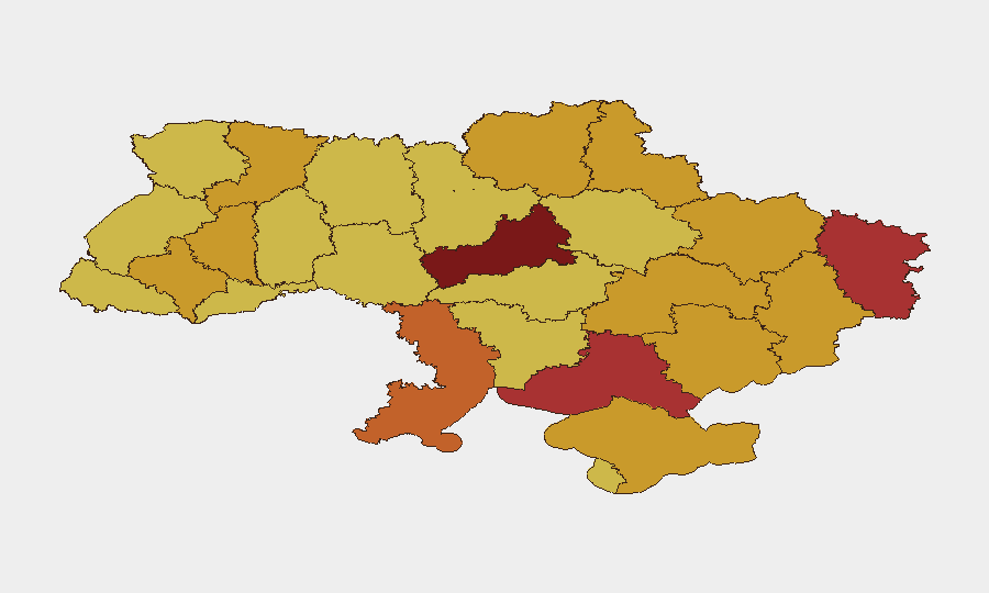
Cherkasy Oblast (risk 100), Kyiv (92.2), and Luhansk Oblast (79) anchor the top tier, with Kyiv's ranking driven by its status as capital, population density, and proven targeting by Russian strike assets. Southern and eastern oblasts—Kherson, Zaporizhia, Donetsk, and occupied Crimea—cluster in the 72–78 range due to proximity to active combat lines, Russian logistics routes, and Ukrainian strike operations. Rivne, Sumy, Dnipropetrovsk, and Ternopil remain elevated (72–73) owing to Russian aerial capability reach and infrastructure targeting across the depth of Ukrainian territory. Risk is driven by kinetic conflict (aerial bombardment, conventional operations), civil-defense disruption, infrastructure interdiction, and transport-route instability.
How GeoBit Would Assist
Security teams would employ AOI Monitoring & Early Warning on high-risk oblasts (Cherkasy, Kyiv, Luhansk, Kherson) with persistent alerting on strike events and casualty reports; Battle Mapping and Conflict Intelligence to track front-line movement and rear-area logistics disruption; and Routing & Network Analysis to model alternative travel and supply routes avoiding strike-prone corridors. OSINT fusion (X/Telegram feeds, Kyiv Independent aggregation, YouTube damage assessment) provides real-time incident corroboration; Satellite & Imagery analysis confirms infrastructure damage and operational impact.
7-Day Outlook
Russian aerial strike tempo is expected to remain elevated through the near term, with Kyiv and other urban centers remaining primary targets. Ukrainian cross-border strike capability suggests continued Russian energy and logistics targeting, sustaining reciprocal escalation risk. Diplomatic activity in Paris may create temporary rhetorical de-escalation but is unlikely to reduce kinetic operations on the ground or in the air.
Highest-Risk Areas — Ranked
| # | State / Region | Risk |
|---|---|---|
| 1 | Cherkasy Oblast | 100 |
| 2 | Kyiv | 92.2 |
| 3 | Luhansk Oblast | 79 |
| 4 | Kherson Oblast | 78.1 |
| 5 | Odesa Oblast | 74.2 |
| 6 | Autonomous Republic of Crimea | 72.9 |
| 7 | Rivne Oblast | 72.6 |
| 8 | Sumy Oblast | 72.5 |
| 9 | Dnipropetrovsk Oblast | 72.4 |
| 10 | Donetsk Oblast | 72 |
| 11 | Ternopil Oblast | 72 |
| 12 | Zaporizhia Oblast | 72 |
Previous Daily Briefs
A new Ukraine brief is written every day — each with its own risk map and downloadable CSV. Here's the last week; use the calendar to go further back.
📅 Browse every day by calendar →
Highlighted days have a brief. Tap a day for that day's map & analysis, or “csv” for that day's dataset ($5).