Situation Summary
Ukraine remains under elevated composite threat (rank #9 globally, 697 tracked events), with high-impact diplomatic and military signals emerging 14–15 July. Recent public statements from France and Germany, combined with concurrent military activity and lawmaker disapproval, indicate intensifying political friction alongside operational tempo. The threat trajectory reflects sustained volatility across political, military, and foreign-relations domains rather than directional escalation or de-escalation.
Key Developments
- 2026-07-15 · Public Statement · LAWMAKER — A senior lawmaker issued a statement; content and portfolio unclear from signal alone, but timing coincides with elevated diplomatic tension. Recommend immediate corroboration via parliamentary records and news wire.
- 2026-07-14 · France & Germany Public Statements vs Ukraine — Both states released critical or cautionary statements regarding Ukraine policy; geopolitical weight suggests potential shift in Western support posture, arms transfer conditions, or diplomatic recognition. Requires urgent clarification via foreign ministry statements and press conferences.
- 2026-07-14 · Conventional Military Force (Ukrainian vs Authorities) — Domestic military or security force engagement detected; nature and location unconfirmed. High priority for duty-of-care teams; escalation risk if linked to political instability or conscription resistance.
- 2026-07-14 · Threat Signal — An unspecified threat against Ukraine or Ukrainian interests was logged. Without attribution or target clarification, corporate teams should assume heightened vigilance around critical infrastructure, government facilities, and supply chains.
- 2026-07-14 · Germany Disapprove (Kyiv) — German disapproval of a Kyiv-based actor or policy; likely diplomatic or military aid–related. May signal conditions on continued support or public cooling of relations.
- 2026-07-14 · Media Disapprove (Ukraine) — Media criticism of Ukrainian state, military, or policy; reinforces political friction and suggests reputational or narrative risk.
- 2026-07-13 · Conventional Military Force (Ukrainian vs Krasnodar) — Ukrainian forces conducted activity in or toward Krasnodar (Russian territory); escalatory signal with potential for Russian retaliation or border incident.
- 2026-07-14 · Investigate · Manufacturer vs Ukraine — An industrial or defense manufacturer initiated investigation into Ukraine-related activity; possible sanctions compliance, export-control, or contract-performance issue.
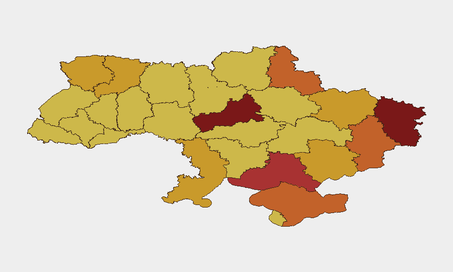
Highest-Risk Areas
Kyiv (rank 1, score 100) and Cherkasy Oblast (rank 2, score 95.6) drive the national risk profile, reflecting capital-city political volatility, infrastructure targeting risk, and proximity to frontline instability. Odesa (83.7) and Kherson (82) remain high-risk due to ongoing military activity and maritime/supply-chain exposure. Kharkiv (74.9) and Dnipropetrovsk (74.9) round out the critical tier, signaling sustained cross-regional military and administrative stress. Eastern and southern oblasts (Luhansk, Donetsk, Zaporizhia) maintain moderate-high risk (71–73) consistent with active conflict zones.
How GeoBit Would Assist
A corporate security team in or serving Ukraine should deploy AOI Monitoring & Early Warning on Kyiv, Cherkasy, and Odesa to detect movement, infrastructure incidents, or supply-chain disruptions in real time. Intel Sweep and X/Telegram OSINT enable corroboration of the 14–15 July statements and threat signals within 2–4 hours, clarifying diplomatic posture and military intent. Conflict & Military mapping and force structure tracking would pinpoint Ukrainian and Russian disposition changes near border hotspots (Krasnodar engagement) to assess retaliation risk and route safety for personnel or convoys.
7-Day Outlook
Diplomatic friction (France, Germany statements) is likely to manifest in public conditions on military aid or sanctions relief within 48–96 hours. Military activity in and around Kyiv and Cherkasy should be monitored for signs of domestic force mobilization or protest; escalation would sharpen risk in the capital. Border incidents (Krasnodar strike) and manufacturer investigations suggest prolonged friction over support continuity and defense-industrial compliance.
Highest-Risk Areas — Ranked
| # | State / Region | Risk |
|---|---|---|
| 1 | Kyiv | 100 |
| 2 | Cherkasy Oblast | 95.6 |
| 3 | Odesa Oblast | 83.7 |
| 4 | Kherson Oblast | 82 |
| 5 | Autonomous Republic of Crimea | 76.3 |
| 6 | Kharkiv Oblast | 74.9 |
| 7 | Dnipropetrovsk Oblast | 74.9 |
| 8 | Zaporizhia Oblast | 73.8 |
| 9 | Volyn Oblast | 73.4 |
| 10 | Luhansk Oblast | 73.2 |
| 11 | Sumy Oblast | 71.9 |
| 12 | Donetsk Oblast | 71.5 |
Sources
Previous Daily Briefs
A new Ukraine brief is written every day — each with its own risk map and downloadable CSV. Here's the last week; use the calendar to go further back.
📅 Browse every day by calendar →
Highlighted days have a brief. Tap a day for that day's map & analysis, or “csv” for that day's dataset ($5).
Atlas — our AI intelligence desk — emails them this snapshot personally. Nothing else, no list.