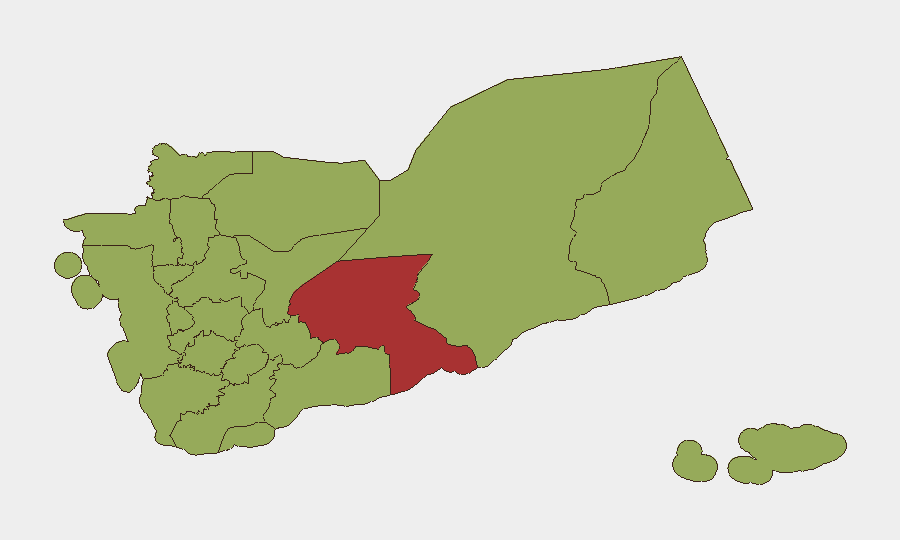
Situation Summary
Yemen remains fractured by civil war, with escalating cross-border military activity involving Israel, Saudi Arabia, and Yemen-based armed groups as of June 9–11. Shabwah Governorate presents the highest composite risk (78.7), while a further ten governorates cluster at 48.7, indicating widespread instability across the north and central zones. The addition of Israeli-Yemeni conventional military exchanges and renewed Saudi artillery strikes signals a shift toward higher-intensity regional involvement, compounding existing humanitarian, criminal, and faction-driven threats across the country.
Key Developments
- 2026-06-09 · Yemen–Israel Military Engagement: Multiple conventional military force events and public statements recorded between Yemen and Israel, suggesting either drone/missile launches from Yemen toward Israeli territory or Israeli defensive/retaliatory operations. Exact locations and casualty counts not yet confirmed in available sources.
- 2026-06-11 · Saudi–Yemen Artillery Clashes: Three separate artillery and tank exchanges logged between Saudi Arabia and Yemen positions, consistent with ongoing coalition interdiction of Houthi (Ansar Allah) positions in border zones and northern governorates.
- 2026-06-09 · Yemen–Djibouti Public Statements: Two public statements issued between Yemen and Djibouti, likely related to maritime or Red Sea security concerns; context and content not detailed in current signal set.
- Regional Escalation Trend: The concentration of Israel-related events on June 9 and Saudi engagement on June 11 suggests a compressed, multi-vector crisis timeline rather than isolated incidents.
- No Major Civilian Infrastructure Attacks Reported: Despite military activity, no mass-casualty events, port bombings, or major supply-line disruptions are flagged in the 24–48 hour window, though maritime chokepoints (Gulf of Aden, Bab al-Mandab) remain under implicit threat from cross-border tensions.
Note on Event Granularity: The event signals above reflect GeoBit's automated global event feed and do not yet include precise geographic coordinates within Yemen, time-of-day stamps, or independent photo/video corroboration. Security teams requiring tactical-level location mapping, casualty figures, or damage assessment should cross-reference UN OCHA situation reports, CENTCOM press advisories, and maritime warnings (UKMTO/EUNAVFOR) released in parallel.
Highest-Risk Areas
Shabwah Governorate's elevated risk (78.7) reflects its dual role as a contested zone between Houthi, Saudi-led coalition, and local armed groups, plus proximity to oil and maritime chokepoints. The subsequent ten governorates at 48.7 span the Houthi heartland (Sa'dah, Sana'a city) and coalition-held or contested zones (Ta'izz, Aden periphery, Hadramawt corridor). Northern governorates—Sa'dah, Hajjah, 'Amran—face sustained tribal conflict and cross-border pressure, while western coastal zones (Al Hudaydah, Raymah) remain vulnerable to sea-based incursions and drone activity. The uniform 48.7 cluster suggests that, outside Shabwah, threat drivers are distributed rather than localized, implying that travel, supply chains, and personnel safety require equal diligence across most of Yemen.
How GeoBit Would Assist
Intel Sweep & OSINT Fusion would cross-reference wires, X/Twitter, NGO alerts, and maritime advisories to confirm location, timing, and type of each reported engagement within 2–4 hours of occurrence. Battle Mapping & Force Structure analysis would track coalition and Houthi positions, allowing security teams to update no-go zones and choke-point avoidance strategies. AOI Monitoring & Early Warning would flag emerging clashes, protest activity, or criminal incidents in user-defined governorates or districts, enabling proactive duty-of-care notifications to staff and asset-protection adjustments.
7-Day Outlook
If Israel-Yemen escalation continues, Houthi drone and missile launches may intensify, increasing risk to shipping in the Red Sea and potential secondary effects on Aden and western ports. Saudi artillery responses will likely cluster in Sa'dah, Hajjah, and 'Amran, sustaining civilian displacement and checkpoints but not dramatically altering territorial control. Security teams should assume elevated alert posture for the next 5–7 days and maintain hourly contact with local partners in Shabwah, Aden, and northern governorates.
Highest-Risk Areas — Ranked
| # | State / Region | Risk |
|---|---|---|
| 1 | Shabwah Governorate | 78.7 |
| 2 | Sa'dah Governorate | 48.7 |
| 3 | Hajjah Governorate | 48.7 |
| 4 | Al Mahwit Governorate | 48.7 |
| 5 | Al Hudaydah Governorate | 48.7 |
| 6 | 'Amran Governorate | 48.7 |
| 7 | Amanat Al Asimah | 48.7 |
| 8 | Sana'a Governorate | 48.7 |
| 9 | Raymah Governorate | 48.7 |
| 10 | Dhamar Governorate | 48.7 |
| 11 | Ibb Governorate | 48.7 |
| 12 | Ta'izz Governorate | 48.7 |
Sources
Previous Daily Briefs
A new Yemen brief is written every day — each with its own risk map and downloadable CSV. Here's the last week; use the calendar to go further back.
📅 Browse every day by calendar →
Highlighted days have a brief. Tap a day for that day's map & analysis, or “csv” for that day's dataset ($5).