Résumé de la situation
La Biélorussie demeure un environnement structurellement contrôlé, à faible incidence d'incidents aigus, avec un classement composite des menaces #151 au niveau mondial (score 5/100). Aucun nouvel incident de sécurité—conflit, protestation, défaillance d'infrastructure ou tension transfrontalière—n'a été corroboré de manière indépendante dans les sources anglophones en accès ouvert au cours des 24–48 dernières heures. Le développement dominant récent est l'alignement stratégique avec la Russie et l'expansion de la coopération économique et logistique avec la Chine (attestée par une réunion de haut niveau du comité Biélorussie–Chine le 17 juin à Minsk), ce qui présente une pertinence géopolitique et de chaîne d'approvisionnement à moyen terme mais n'altère pas la posture de sécurité immédiate.
Développements clés
- Minsk, Biélorussie – 17 juin 2026 – Troisième réunion du Comité de haut niveau Biélorussie–Chine
Une réunion de coopération stratégique s'est tenue au Conseil de la République, portant sur les liens économiques et logistiques. Bien que ne constituant pas un incident de sécurité direct, l'approfondissement de l'intégration transport et industrielle Chine–Biélorussie peut influer sur le risque d'infrastructure à long terme et les dépendances de chaîne d'approvisionnement de tiers pour les opérateurs internationaux.
- Biélorussie (national) – 16–18 juin 2026 – Aucun incident de sécurité aigu confirmé en OSINT
La surveillance systématique des actualités anglophones, des médias sociaux et de l'OSINT en accès ouvert au cours des 24–48 dernières heures n'a pas identifié d'événements de sécurité vérifiables et horodatés (attaques, manifestations massives, affrontements frontaliers, défaillances d'infrastructure) en Biélorussie. L'environnement politique répressif de base et les contraintes structurelles sur la liberté d'expression restent en place mais ne montrent aucun incident déclencheur nouveau.
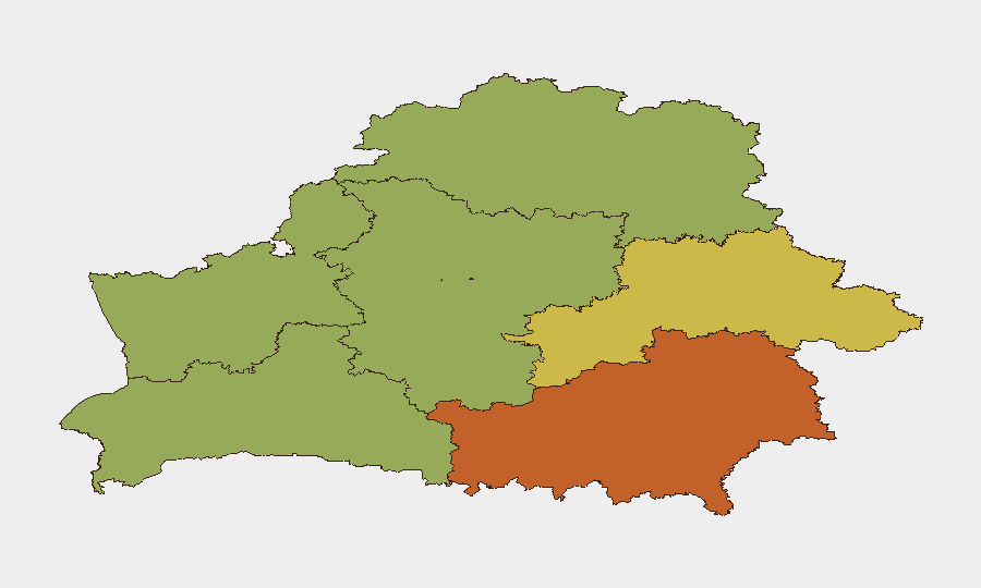
Zones à risque maximal
La région de Minsk (risque composite 31,4) surclasse significativement toutes les autres divisions administratives de Biélorussie, déterminant le risque agrégé national. Ceci reflète la concentration de Minsk en gouvernement, présence des forces de sécurité et infrastructure d'État, conjugée à la sensibilité politique résiduelle suivant le cycle électoral de 2020. La ville de Minsk proprement dite (risque 3,8) porte un risque classé inférieur, probablement reflétant un périmètre de sécurité plus strict et une présence internationale plus visible. Les régions de Vitebsk, Grodno, Brest, Moguilev et Gomel se regroupent à risque 1,4, indiquant des profils d'incidents relativement uniformes et faibles dans les zones périphériques.
Comment GeoBit pourrait vous assister
Intel Sweep et fusion OSINT multilingue (Telegram, X, sources russophones) fourniraient une détection précoce des troubles civils émergents, incidents frontaliers ou perturbations d'infrastructure avant que les médias grand public anglophones les signalent. AOI Monitoring & Early Warning sur la région de Minsk et les plaques tournantes transport/logistique clés flagueraient les rassemblements politiquement sensibles ou les déploiements de sécurité anormaux. Economic & Trade monitoring et Network & Actor Analysis suivraient l'intégration militaire Biélorussie–Russie et l'expansion logistique Chine–Biélorussie, permettant aux équipes d'entreprise d'évaluer le risque de chaîne d'approvisionnement et réglementaire à long terme aux actifs dans le pays.
Perspectives sur 7 jours
Aucune escalade aiguë de sécurité n'est anticipée au cours des 7 prochains jours selon l'OSINT actuel et les indicateurs structurels. La trajectoire à moyen terme reste façonnée par l'alignement militaire et politique Russie–Biélorussie et la coopération d'infrastructure Chine–Biélorussie ; les équipes d'entreprise doivent surveiller les changements réglementaires ou les développements de conformité liés aux sanctions plutôt que de s'attendre à des conflits proches ou des troubles de masse. La surveillance directe des médias biélorusses primaires (Belsat) et des canaux Telegram russophones est recommandée pour capturer les développements émergents non encore indexés dans les flux d'actualités anglophones.
Données au 18-06-2026 06:00 UTC. Mise à jour suivante : 19-06-2026 06:00 UTC.
Zones les Plus à Risque — Classées
| # | État / Région | Risque |
|---|---|---|
| 1 | Minsk Region | 31.4 |
| 2 | Minsk | 3.8 |
| 3 | Vitsebsk Region | 1.4 |
| 4 | Hrodna Region | 1.4 |
| 5 | Brest Region | 1.4 |
| 6 | Mahilyow Region | 1.4 |
| 7 | Homyel Region | 1.4 |
Sources
Bulletins Quotidiens Précédents
Un nouveau bulletin Belarus est publié chaque jour — chacun avec sa carte de risque et son CSV téléchargeable. Voici la dernière semaine ; utilisez le calendrier pour remonter plus loin.
📅 Browse every day by calendar →
Highlighted days have a brief. Tap a day for that day's map & analysis, or “csv” for that day's dataset ($5).