Situation Summary
Latvia remains at low overall threat intensity (composite score 9; #153 globally), with no major security incidents recorded in the past week. However, the country faces persistent and escalating hybrid-threat pressure along its eastern border with Belarus, characterized by organized illegal-migration attempts, infrastructure sabotage, and retaliatory trade measures. Government response has included expansion of border-security powers and diplomatic escalation within the EU framework.
Key Developments
- Latvia–Belarus border, 14 October: Latvian border guards intercepted 19 people attempting illegal entry from Belarus; authorities logged 22 total offenders at external and internal borders that day.
- Riga, 14–15 October: Latvia hosted CyberChess 2026, a cybersecurity conference addressing AI-enabled attack vectors, critical-infrastructure resilience, and crisis-response protocols—reflecting institutional focus on hybrid threats.
- Eastern border, 14 October: Prime Minister Andris Kulbergs announced government approval of expanded enforcement powers for border-protection services, following an early-October incident involving armed masked individuals, migrant groups, and damage to monitoring and power-distribution infrastructure.
- Latvia–Belarus border, 15 October: Border guards stopped 36 people crossing illegally from Belarus; officials registered 37 total offenders at borders and within Latvia.
- Daugavpils and eastern border, 15 October: Interior Minister Jānis Dombrava and Border Guard chief Guntis Pujāts conducted inspections of border facilities and discussed illegal migration, hybrid threats, and security enhancements with frontline personnel.
- Latvia nationwide, 16 October: Police reported worsening response delays attributed to staff shortages; 16 cases of assault on officers or disobedience to lawful orders were registered during the preceding week.
- Latvia–Belarus border, 19 October: Belarus announced a ban on imports of Latvian food and industrial goods in retaliation for the border confrontation involving armed escorts, migrant groups, surveillance-equipment damage, and relay-cabinet destruction.
- EU diplomatic policy, 19–20 October: Latvia renewed its call for an EU-wide tourist-visa ban on Russian citizens, citing border-security deterioration and hybrid-threat escalation.
Highest-Risk Areas
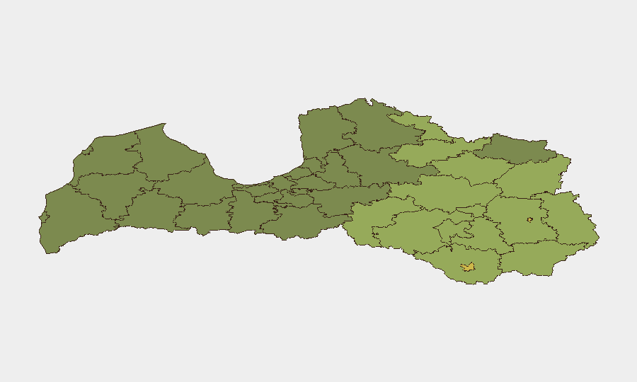
Rēzekne and Daugavpils (scores 68 and 65, respectively) dominate sub-national risk rankings, reflecting their proximity to the Belarus border and concentration of illegal-migration, smuggling, and sabotage activity. Rural eastern administrative divisions—Rēzeknes novads, Ludzas novads, and Balvu novads—score between 52 and 58, indicating that threat density extends beyond urban centers into cross-border transit routes and infrastructure zones. This geographic pattern reflects Belarus-originating hybrid operations: organized migrant trafficking, armed escort activity, and targeted infrastructure damage designed to test Latvian response capacity and create political friction.
How GeoBit Would Assist
Security teams should deploy GeoBit's AOI Monitoring & Early Warning capability on the eastern border corridor and key infrastructure nodes to detect repeated smuggling, sabotage staging, and escalation patterns in near-real time. Intel Sweep and OSINT fusion (X/Telegram feeds, media monitoring, entity tracking) enable continuous watch on Belarusian-side actor networks, migrant-routing intelligence, and sanctions/trade-policy signals. Sentiment & temporal analysis of Belarusian state communications and trade measures identifies windows of heightened confrontation risk.
7-Day Outlook
Illegal-migration pressure and low-level infrastructure sabotage are likely to persist at current or elevated tempo through late October, with Belarus trade measures signaling political hardening. Police capacity constraints and border-guard staffing remain near-term operational vulnerabilities. Escalation risk remains moderate; deliberate military provocation is unlikely, but coordinated migrant-smuggling incidents with infrastructure damage should be anticipated.
Highest-Risk Areas — Ranked
| # | State / Region | Risk |
|---|---|---|
| 1 | Rēzekne | 68 |
| 2 | Daugavpils | 65 |
| 3 | Rēzeknes novads | 58 |
| 4 | Ludzas novads | 55 |
| 5 | Balvu novads | 52 |
| 6 | Preiļu novads | 50 |
| 7 | Krāslavas novads | 48 |
| 8 | Jēkabpils novads | 47 |
| 9 | Augšdaugavas novads | 46 |
| 10 | Aizkraukles novads | 45 |
| 11 | Varakļānu novads | 44 |
| 12 | Līvānu novads | 43 |
Sources
Previous Weekly Briefs
A new Latvia brief is written every Monday, covering the week — each with its own risk map and downloadable CSV. Use the calendar to go further back.
- October 13, 2026
- October 6, 2026
- September 29, 2026
- September 22, 2026
- September 15, 2026
- September 8, 2026
- September 1, 2026
📅 Browse past briefs by calendar →
Highlighted days have a brief. Tap a day for that day's map & analysis, or “csv” for that day's dataset ($5).
Atlas — our AI intelligence desk — emails them this snapshot personally. Nothing else, no list.