Situation Summary
Guinea-Bissau's domestic territory remains calm with no verified security incidents, civil unrest, or infrastructure failures reported in the last 24–48 hours. However, the country faces sustained regional diplomatic pressure following a 21 July ECOWAS summit communique demanding the unconditional release of detained opposition leader Domingos Simões Pereira and a return to democratic governance—a signal of potential future sanctions or external intervention if the military-backed government does not comply. Additionally, a Guinea-Bissau-flagged cargo vessel was struck by Russian missiles in the Black Sea on 19 July, killing 10 personnel and highlighting elevated maritime-security risk for vessels operating under the country's registry. Overall, the threat profile is characterized by internal calm coupled with rising political-instability risk and external maritime exposure.
Key Developments
- Freetown, Sierra Leone – 21 July 2026: ECOWAS heads of state issued a communique explicitly demanding the release of opposition leader Domingos Simões Pereira and calling for a return to democratic norms, signaling potential future regional sanctions or intervention if demands are not met.
- ECOWAS monitoring centers – 21 July 2026: Regional intelligence sources report active ECOWAS monitoring of Guinea-Bissau's response to the summit communique, framing non-compliance as a potential escalation pathway and political crisis trigger.
- Lisbon, Portugal – 21 July 2026: Dozens of Bissau-Guinean diaspora protesters gathered outside CPLP headquarters demanding international intervention and sanctions against Guinea-Bissau's military leadership; no violence or arrests reported.
- Black Sea, off Odesa, Ukraine – 19 July 2026 (reported 20 July): Guinea-Bissau-flagged Turkish-owned bulk carrier *Golden Leo* struck by Russian cruise missiles, resulting in 10 confirmed deaths (nine crew, one Ukrainian pilot) and eight rescues; Ukrainian naval authorities labeled the strike a terrorist act and flagged elevated risk to Guinea-Bissau–flagged shipping in the Black Sea corridor.
- Bissau and national road network – 19–20 July 2026: Monitoring confirmed no abrupt deterioration in petty crime, transport conditions, or movement restrictions; existing foreign travel advisories remain in effect with routine precautions.
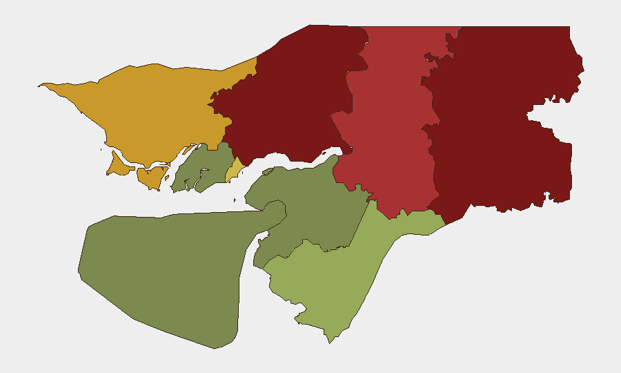
Highest-Risk Areas
Gabu Region (risk score 92) remains the dominant driver of sub-national risk, followed by Oio (85) and Bafatá (78) in the northeast. These border-proximate regions historically experience higher narcotics trafficking, cross-border smuggling, and armed-group activity; they warrant enhanced monitoring despite the current absence of acute incidents. The capital region (Bissau Autonomous Sector, risk 68) carries elevated political-instability risk given the junta's detention of opposition figures and mounting regional and diaspora pressure. Southern and island regions (Tombali, Quinara, Bolama) present substantially lower risk profiles and remain suitable for routine operations.
How GeoBit Would Assist
Security teams should deploy AOI Monitoring & Early Warning on Gabu, Oio, and Bafatá regions to detect emerging armed or trafficking activity; pair this with OSINT fusion and multi-language social-media and news intelligence (X/Twitter, Telegram, local radio) to track political developments and diaspora messaging in real time. Maritime tracking of Guinea-Bissau–flagged vessels and regime-stability assessment tools should be activated to flag further political escalation or external pressure that could shift the domestic security calculus.
7-Day Outlook
Over the next 7 days, the political and diplomatic pressure on Guinea-Bissau's military government is likely to intensify if Pereira is not released, with ECOWAS potentially announcing targeted sanctions or suspension measures. The domestic security environment is expected to remain calm in the absence of major political clashes, though tensions could escalate rapidly if the regime responds to regional or diaspora activism with arrests or restrictions. Maritime risk for Guinea-Bissau–flagged vessels in the Black Sea and other conflict zones will remain elevated.
Highest-Risk Areas — Ranked
| # | State / Region | Risk |
|---|---|---|
| 1 | Gabu Region | 92 |
| 2 | Oio Region | 85 |
| 3 | Bafatá Region | 78 |
| 4 | Cacheu Region | 72 |
| 5 | Bissau Autonomous Sector | 68 |
| 6 | Tombali Region | 45 |
| 7 | Quinara Region | 38 |
| 8 | Biombo Region | 32 |
| 9 | Bolama Region | 15 |
Sources
Previous Daily Briefs
A new Guinea-Bissau brief is written every day — each with its own risk map and downloadable CSV. Here's the last week; use the calendar to go further back.
📅 Browse every day by calendar →
Highlighted days have a brief. Tap a day for that day's map & analysis, or “csv” for that day's dataset ($5).
Atlas — our AI intelligence desk — emails them this snapshot personally. Nothing else, no list.