Situation Summary
Cape Verde remains a low-threat jurisdiction globally (rank #170, composite score 5), with no tracked security events or indicators of civil unrest, organized crime, or political instability. However, a catastrophic transport accident on Fogo Island on 5 September 2026—in which a passenger bus carrying 32 people, predominantly schoolchildren, plunged 30 meters off a mountain road, killing approximately 25 and injuring 14—has triggered a major national crisis response and exposed systemic vulnerabilities in rural road safety and informal transport regulation. The incident and its aftermath carry direct implications for travel risk on interisland and mountain routes.
Key Developments
- Fogo Island, Campanas de Cima road (5 Sep, evening): Passenger bus carrying ~32 people, mostly schoolchildren returning from Pico do Fogo crater excursion, veered off mountain road and fell ~30 m into ravine; ~25 fatalities and 14 injuries confirmed by 6 Sep. Driver died in crash.
- Fogo Island (6 Sep): Authorities and media converged on 25 confirmed dead; civil protection and national officials confirmed casualty figures after initial uncertainty; most victims identified as primary and secondary students.
- Fogo Island (5–7 Sep): Trip characterized as privately arranged annual excursion by bus driver, not official school operation; route ran from São Filipe to Chã das Caldeiras inside crater. Highlights informal, lightly regulated group transport for children on hazardous terrain.
- Fogo Island (6–8 Sep): Government deployed ~16 additional medical personnel to island hospitals; ongoing search-and-rescue, triage, and crash-site investigation continued through 8 Sep; local health infrastructure reported temporary strain.
- National (6–7 Sep): Government declared two days of national mourning effective midnight 6 Sep; flags ordered to half-mast at public buildings and diplomatic missions nationwide; public celebrations and performances cancelled across archipelago.
- Praia (6–7 Sep): President José Maria Neves and Prime Minister Francisco Carvalho travelled to Fogo, attended funerals, confirmed 25 dead / 14 injured, and publicly ordered full investigation; incident described as "a great catastrophe."
- International (7 Sep): UAE and other states issued official condolences and solidarity statements regarding crash; signals potential external support for infrastructure or safety measures.
- Fogo Island (6–8 Sep): Cause of accident remains under investigation; authorities examining road conditions on steep Campanas de Cima section, possible vehicle defects or driver error, and adequacy of rural transport safety oversight.
Highest-Risk Areas
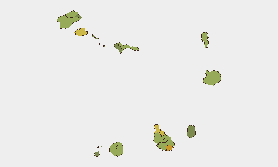
Praia (risk 72) and São Miguel (68) lead the sub-national ranking, followed by São Vicente (65) and Tarrafal (62). Fogo Island's São Filipe municipality (58) and Santa Catarina (58) are now focal points for transport-safety and infrastructure risk following the bus crash. The concentration of higher scores in Praia, São Miguel, and São Vicente reflects these islands' population density and economic activity; São Filipe's elevation reflects the acute incident and resulting uncertainty around road safety on steep mountain routes used for inter-community travel and tourism.
How GeoBit Would Assist
Security teams with personnel or assets in Cape Verde would deploy AOI Monitoring & Early Warning to track Fogo Island and other high-risk interisland transport corridors for emerging incidents; Routing & Network Analysis to identify alternative travel paths and hazard zones (e.g., mountain roads prone to accidents); and Risk & Threat Assessment integrating real-time event feeds and OSINT (social media, local news) to flag transport or infrastructure failures. Satellite & Imagery analysis can assess road condition and landslide risk on vulnerable routes.
7-Day Outlook
Authorities will continue investigation into crash causation and regulatory gaps in rural transport; policy or safety measures may follow within 1–2 weeks. Travel risk on Fogo Island mountain routes and informal interisland bus services remains elevated pending findings. No indicators suggest widening civil unrest or secondary incidents; risk trajectory is containment and remediation.
Highest-Risk Areas — Ranked
| # | State / Region | Risk |
|---|---|---|
| 1 | Praia | 72 |
| 2 | São Miguel | 68 |
| 3 | São Vicente | 65 |
| 4 | Tarrafal | 62 |
| 5 | São Filipe | 58 |
| 6 | Santa Catarina | 58 |
| 7 | Santa Cruz | 55 |
| 8 | Mosteiros | 52 |
| 9 | São Salvador do Mundo | 52 |
| 10 | Ribeira Grande | 50 |
| 11 | Porto Novo | 48 |
| 12 | Sal | 48 |
Sources
Previous Weekly Briefs
A new Cape Verde brief is written every Monday, covering the week — each with its own risk map and downloadable CSV. Use the calendar to go further back.
- September 2, 2026
- August 30, 2026
- August 27, 2026
- August 24, 2026
- August 22, 2026
- August 20, 2026
- August 18, 2026
📅 Browse past briefs by calendar →
Highlighted days have a brief. Tap a day for that day's map & analysis, or “csv” for that day's dataset ($5).
Atlas — our AI intelligence desk — emails them this snapshot personally. Nothing else, no list.