ملخص الوضع
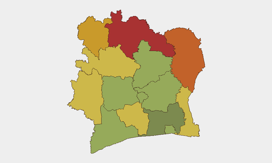
تتمتع ساحل العاج بالاستقرار النسبي على المستوى الوطني، مع درجة تهديد مركبة تبلغ 5 وعدم تسجيل أي حوادث أمنية منفصلة في نافذة الإبلاغ الحالية. ومع ذلك، تستمر مناطق الحدود الشمالية—مقاطعات السافانا وزنزان ودينغويليه—في تحمل مخاطر مرتفعة (درجات 72–78)، مما يعكس ضغوطاً عابرة للحدود مستمرة وقدرة دولة محدودة في تلك المناطق. العاصمة والمركز الاقتصادي الرئيسي، أبيدجان، يبقى تحت مخاطر معتدلة (45)، متسقاً مع جرائم حضرية أساسية وأنماط الاتجار. المسار العام يشير إلى عدم وجود أزمة وطنية وشيكة، لكن الثغرات المحلية في الشمال تستحق المراقبة المستمرة.
التطورات الرئيسية
لم يتم تأكيد أي حوادث أمنية أو اضطرابات مدنية أو جرائم أو بنية تحتية أو حوادث سياسية رئيسية في ساحل العاج خلال 24–48 ساعة السابقة لهذا الموجز (16–18 يونيو 2026 بتوقيت UTC). الإبلاغ من المصادر المفتوحة من وسائل الإعلام الإقليمية والمصادر الحكومية والمنصات الاجتماعية لم يسفر عن حوادث مختومة بالوقت والموقع الجغرافي تفي بمعايير التشغيل للإدراج. العمليات الأمنية الروتينية والجرائم البسيطة والنشاط الإداري تستمر بكل تأكيد، لكنها تفتقر إلى توثيق عام كافٍ للإبلاغ التكتيكي. الفرق التي تتطلب تأكيد حادثة فوري يجب أن توكل مراقبة الإعلام الناطق بالفرنسية المحلي والبيانات الأمنية الحكومية بالتوازي مع هذا الموجز.
أعلى المناطق المعرضة للخطر
تقود المناطق الشمالية—السافانا (78) وزنزان (75) ودينغويليه (72)—الملف الشامل لمخاطر البلاد. تقع هذه المقاطعات عبر حدود مالي وبوركينا فاسو، حيث يخلق نشاط المجموعات المسلحة غير الحكومية وشبكات التهريب والميليشيات عدم الاستقرار المستمر. الحضور الإداري والأمني للدولة ضعيف؛ التوترات بين المجتمعات والرعاة متوطنة. مقاطعات مونتاني وويروبا (68 و65) تمثل مخاوف ثانوية، مما يعكس ديناميكيات حدودية مماثلة والمنافسة على الموارد. درجة أبيدجان المعتدلة (45) تعكس تركيز الجرائم الحضرية والسرقة الصغيرة والاتجار بدلاً من العنف المنظم؛ المناطق التجارية والموانئ وسط المدينة تحمل مخاطر فردية أعلى من الضواحي. تبقى المقاطعات الوسطى والساحلية منخفضة المخاطر بشكل كبير.
كيف سيساعد GeoBit
يجب تكليف مراقبة المنطقة المهمة والإنذار المبكر على مقاطعات السافانا وزنزان ودينغويليه مع تنبيهات معايرة للحركة عابرة للحدود وإشارات نشاط المجموعات المسلحة والاضطراب الإداري. دمج الاستخبارات مفتوحة المصدر الذي يجمع بين X/تويتر الناطقة بالفرنسية والإشارات الراديوية المحلية وتغذيات الصراع الإقليمية سيسد الفجوات في الإبلاغ الرسمي ويوفر وقت استباق 4–6 ساعات على حدوث تصعيدات محلية. تحليل الشبكة والممثلين سيرسم خرائط للتهريب والخلايا الميليشياوية العاملة في الشمال، مما يدعم التخطيط للمسارات وتطبيق المخاطر على الأفراد لأي عمليات في تلك المناطق أو العابرة لها. تحليل التوجيه والشبكة يمكن أن يحدد بدائل سفر قوية حول السافانا وزنزان تقلل التعرض لنقاط التفتيش المعروفة والممرات المتقلبة.
آفاق 7 أيام
لا يتوقع أي تصعيد كبير خلال الأيام السبعة القادمة في غياب حادثة عابرة للحدود أو محفز سياسي رئيسي. سيستمر نشاط المجموعات المسلحة الروتيني والاحتكاك بين المجتمعات في الشمال؛ الاضطرابات المحلية للتجارة والنقل وتقديم الخدمات ممكنة لكنها ليست وشيكة. يجب أن يبقى موقف المخاطر عند الأساس الحالي مع اليقظة المرتفعة في المنطقة الشمالية واحتياطات جرائم حضرية معيارية في أبيدجان والمدن الثانوية.
المناطق الأعلى خطورة — مرتبة
| # | الولاية / المنطقة | الخطر |
|---|---|---|
| 1 | Savanes District | 78 |
| 2 | Zanzan District | 75 |
| 3 | Denguélé District | 72 |
| 4 | Comoé District | 70 |
| 5 | Montagnes District | 68 |
| 6 | Woroba District | 65 |
| 7 | Gôh-Djiboua District | 60 |
| 8 | Sassandra-Marahoué District | 58 |
| 9 | Vallée du Bandama District | 55 |
| 10 | Bas-Sassandra District | 52 |
| 11 | Lacs District | 48 |
| 12 | Abidjan | 45 |
المصادر
الموجزات اليومية السابقة
يُنشر موجز جديد عن Ivory Coast كل يوم — لكل منها خريطة مخاطر وملف CSV قابل للتنزيل. هذا هو الأسبوع الأخير؛ استخدم التقويم للرجوع أبعد.
📅 Browse every day by calendar →
Highlighted days have a brief. Tap a day for that day's map & analysis, or “csv” for that day's dataset ($5).