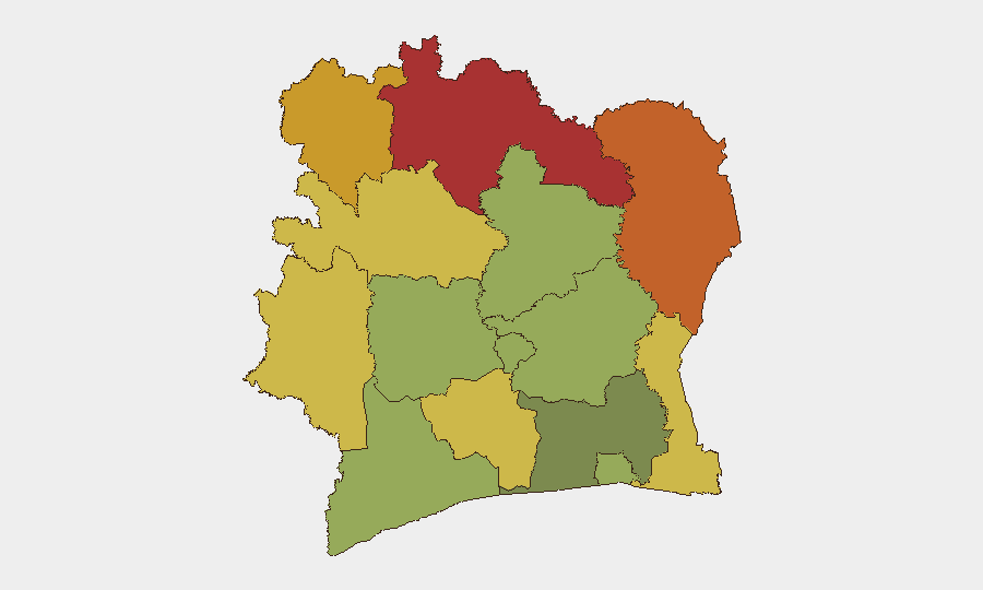
Situation Summary
Ivory Coast remains a moderate global security risk (rank #60, composite score 32) with no tracked major incidents this week, but localized crime, civil unrest, and resource-related instability persist across the northern savanna belt and cocoa-growing regions. The security environment is characterized by recurring petty crime in urban centers (Abidjan, Bouaké), farmer-led protests over commodity pricing, youth-driven disorder, and a sustained counter-terrorism focus reinforced by new US–Ivorian cooperation announced 5 September. The overall trend is one of contained but fragmented low-level unrest rather than systemic collapse, with authorities responding reactively to urban crime and agricultural grievance.
Key Developments
- Abidjan, Cocody II–Plateaux–Agban (31 August 2026): Headquarters of COVICI, a victims' rights civil-society organization, targeted in a burglary; complaint filed with 12th arrondissement police (Deux-Plateaux). Described as a "new" burglary, suggesting a recurring crime risk against NGO infrastructure in affluent central Abidjan.
- Bouaké, Sokoura neighborhood (30 August 2026, reported 1 September): Municipal authorities seized multiple motorbikes and intervened against organized parades causing public disorder and traffic hazards; part of an escalating municipal enforcement campaign against urban road insecurity.
- Man, Tonkpi region (early September 2026, reported 1 September): Interior and Security Minister Vagondo Diomandé visited to address traders affected by a market fire and warn youth against "repeated acts of contestation and disorder," signaling official concern over local instability and youth-driven unrest.
- M'Batto, cocoa belt (late August, reported 5 September 2026): Farmer protests over unpaid cocoa sales and rotting inventory led to road blockades and clashes with police involving tear gas; Coffee and Cocoa Council dispatched senior management to contain unrest and prevent regional spread.
- National level (5 September 2026): Côte d'Ivoire and the United States announced reinforced border security and counter-terrorism cooperation, signaling joint emphasis on preventive security and cross-border threat mitigation.
- Nationwide (early September, media focus): Clandestine gold mining (orpaillage clandestin) and its alleged political linkages returned to public discourse, with claims of involvement in 29 of 31 regions; reflects chronic resource-crime and governance concerns driving instability.
Highest-Risk Areas
The northern savanna districts dominate the risk landscape: Savanes, Zanzan, Denguélé, Comoé, and Montagnes districts (risk scores 78–68) reflect a persistent concentration of banditry, porous borders, and weak state presence inherited from earlier regional conflict. These remote, sparsely administered zones remain vulnerable to armed robbery (as evidenced by the 30 August Tanda impersonation robbery) and cross-border criminal networks. Mid-tier risk zones (Woroba, Gôh-Djiboua, Sassandra-Marahoué) encompass cocoa-belt and rural commercial corridors where commodity-related disputes and farmer unrest are now escalating. Abidjan itself (risk 45) continues to experience petty and organized crime despite being the administrative and commercial hub, reflecting urban security management challenges.
How GeoBit Would Assist
Security teams should deploy AOI Monitoring & Early Warning on northern border districts and cocoa-belt regions (M'Batto, Séguéla, Tanda) to detect emerging armed-robbery patterns and farmer-protest escalation. Intel Sweep, multi-language OSINT, and X/Twitter–Telegram intelligence would surface grassroots unrest (youth disorder, market incidents, commodity disputes) before they trigger enforcement responses. Network & Actor Analysis applied to trafficking and clandestine mining networks would clarify the political and criminal linkages now surfacing in public discourse.
7-Day Outlook
Farmer unrest in the cocoa belt is likely to remain volatile if pricing disputes and payment defaults persist; the Coffee and Cocoa Council's intervention may stabilize M'Batto but risks contagion to neighboring growing zones. Urban crime (robbery, burglary) in Abidjan and Bouaké will continue at baseline levels; municipal enforcement in Bouaké may temporarily disrupt motorbike-related disorder but reflects chronic traffic-safety challenges. Regional counter-terrorism cooperation will proceed without immediate visible operational changes, maintaining baseline northern-border vigilance.
Highest-Risk Areas — Ranked
| # | State / Region | Risk |
|---|---|---|
| 1 | Savanes District | 78 |
| 2 | Zanzan District | 75 |
| 3 | Denguélé District | 72 |
| 4 | Comoé District | 70 |
| 5 | Montagnes District | 68 |
| 6 | Woroba District | 65 |
| 7 | Gôh-Djiboua District | 60 |
| 8 | Sassandra-Marahoué District | 58 |
| 9 | Vallée du Bandama District | 55 |
| 10 | Bas-Sassandra District | 52 |
| 11 | Lacs District | 48 |
| 12 | Abidjan | 45 |
Sources
Previous Weekly Briefs
A new Ivory Coast brief is written every Monday, covering the week — each with its own risk map and downloadable CSV. Use the calendar to go further back.
- September 2, 2026
- September 1, 2026
- August 31, 2026
- August 30, 2026
- August 28, 2026
- August 26, 2026
- August 25, 2026
📅 Browse past briefs by calendar →
Highlighted days have a brief. Tap a day for that day's map & analysis, or “csv” for that day's dataset ($5).
Atlas — our AI intelligence desk — emails them this snapshot personally. Nothing else, no list.