Situation Summary
Ivory Coast remains a moderate-risk operating environment (global rank #93, composite score 7/10) with persistent but not acute security pressures. The bulk of documented threat activity is concentrated in the northern and northwestern border districts—Savanes, Zanzan, and Denguélé—where cross-border trafficking, militia activity, and weak state presence create elevated risk. Abidjan and the southern coastal zones remain relatively stable, though civil tensions and governance friction are present across multiple institutional actors. No major escalation or acute crisis has been identified in the last 24–48 hours.
Key Developments
No well-sourced, corroborated security incidents have been identified inside Ivory Coast in the last 24–48 hours. Current open-source reporting is dominated by non-security topics (2026 World Cup travel and visa matters involving Ivorian supporters abroad).
Standing watch: GeoBit sensors and OSINT fusion are actively monitoring for:
- Cross-border security incidents (Mali, Burkina Faso, Guinea borders)
- Civil unrest or protest activity in urban centers
- Judicial/detention-related civil-rights tensions (recent signals include arrest/detention events and ministry–civilian friction)
- Public statements by civilians and institutions that may signal emerging grievances
No major incidents meeting GeoBit's incident threshold have been triggered in the past 48 hours.
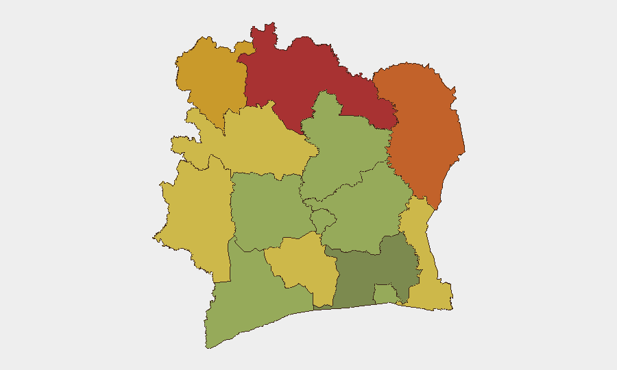
Highest-Risk Areas
Northern and northwestern districts—Savanes (78), Zanzan (75), and Denguélé (72)—drive the majority of Ivory Coast's composite threat score. These regions face chronic instability rooted in porous borders with Mali and Burkina Faso, illicit trafficking networks, weak governance, and spillover from Sahel-wide conflict. Comoé District (70) and Montagnes District (68) extend this risk corridor eastward and southward along border areas. By contrast, Abidjan (45) and coastal southern districts show lower but non-trivial risk, primarily from civil tension, crime, and governance friction rather than armed conflict. Operational footprints in the north require heightened vigilance; southern urban zones require standard urban-security protocols.
How GeoBit Would Assist
AOI Monitoring & Early Warning: Persistent watch on Savanes, Zanzan, and Denguélé districts with automated alerting for cross-border movement, militia activity, and security-force clashes would provide corporate teams 24–48 hours' lead time before escalation reaches operational zones.
Intel Sweep & OSINT Fusion: Multi-language OSINT fusion (X/Twitter, Telegram, local radio SIGINT, and humanitarian/NGO feeds) tracks civil unrest, judicial actions, and institutional friction—critical for understanding second-order risks to expat staff and supply-chain continuity.
Routing & Network Analysis: Real-time alternative routing for personnel and supply movements, particularly northern routes vulnerable to roadblocks, militia checkpoints, and trafficking interdiction.
7-Day Outlook
No acute escalation is anticipated in the near term, but the northern border region will remain a chronic pressure point. Monitor for any spillover from ongoing Sahel conflicts (Mali, Burkina Faso) or cross-border trafficking enforcement actions. Domestic civil-institutional friction (arrest/detention signals, ministry disapproval events) suggests underlying governance stress; sustained monitoring will clarify whether this reflects seasonal administrative activity or emerging political tension ahead of any scheduled national events.
Highest-Risk Areas — Ranked
| # | State / Region | Risk |
|---|---|---|
| 1 | Savanes District | 78 |
| 2 | Zanzan District | 75 |
| 3 | Denguélé District | 72 |
| 4 | Comoé District | 70 |
| 5 | Montagnes District | 68 |
| 6 | Woroba District | 65 |
| 7 | Gôh-Djiboua District | 60 |
| 8 | Sassandra-Marahoué District | 58 |
| 9 | Vallée du Bandama District | 55 |
| 10 | Bas-Sassandra District | 52 |
| 11 | Lacs District | 48 |
| 12 | Abidjan | 45 |
Sources
Previous Daily Briefs
A new Ivory Coast brief is written every day — each with its own risk map and downloadable CSV. Here's the last week; use the calendar to go further back.
📅 Browse every day by calendar →
Highlighted days have a brief. Tap a day for that day's map & analysis, or “csv” for that day's dataset ($5).