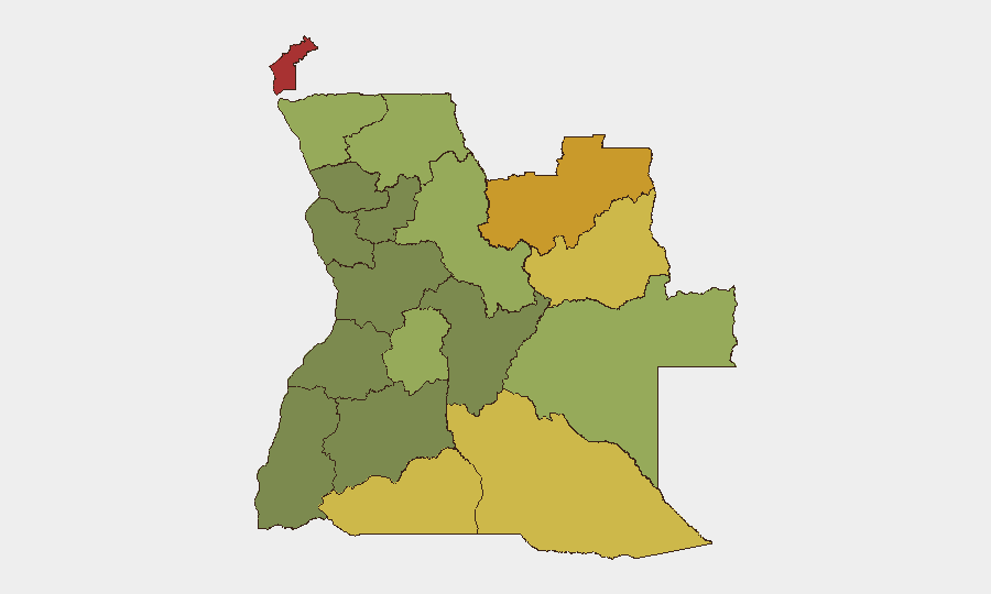
Situation Summary
Angola remains a moderate-risk operating environment (global rank #64) with a composite threat score of 31 and no tracked critical incidents to date in 2026. The threat landscape is geographically concentrated in the eastern and northeastern provinces, where resource extraction, border instability, and residual conflict dynamics elevate risk. Wildfire activity across multiple provinces is currently the most widespread documented hazard, though small-arms combat signals have emerged in the last 48 hours and warrant monitoring.
Key Developments
- Small Arms Combat (2026-06-21): Two separate small-arms engagements reported on 21 June; geographic specificity and casualty/actor data not yet confirmed. Status of combatants and incident location require clarification from local sources.
- Wildfire Activity (ongoing, last 10 days): At least 11 wildfire events logged across Angola and into neighboring DRC since mid-June, affecting multiple provinces. Active fire zones and smoke displacement into populated areas or transport corridors have not yet been specified; air quality and evacuation risk currently unknown.
- Regional Pattern: Combat and fire activity overlap geographically in eastern Angola (Lunda, Moxico regions), complicating assessment of whether incidents are operationally linked or coincidental.
Highest-Risk Areas
Cabinda Province (risk 78) remains the highest-threat zone, driven by historical separatist activity, resource competition, and proximity to DRC instability. The Lunda Norte and Lunda Sul provinces (72 and 68 respectively) follow closely, reflecting ongoing artisanal and industrial diamond-sector tensions, smuggling networks, and cross-border movement of armed actors. Cuando Cubango, Cunene, and Moxico provinces (64, 62, 58) form a secondary arc of concern along the southern and eastern borders, where wildlife trafficking, informal mining, and cattle rustling fuel localized conflict. Together, these six provinces account for the majority of documented security incidents and represent the primary operating constraint for international personnel and supply chains in Angola.
How GeoBit Would Assist
AOI Monitoring & Early Warning would enable real-time tracking of the Cabinda and Lunda cluster, with automated alerts on combat, movement, and wildfire progression to flag escalation before it affects corporate operations. Conflict & Military mapping and Network & Actor Analysis would clarify which armed groups are responsible for the 21 June engagements and whether they are active across multiple provinces simultaneously. Satellite & Imagery Analysis would pinpoint active fire zones, smoke plumes, and road access degradation, allowing duty-of-care teams to reroute supply lines and personnel proactively. Routing & Network Analysis would identify alternative transport corridors in real time to bypass fire or conflict zones.
7-Day Outlook
The immediate trend is toward consolidation of data on the 21 June combat incidents and tracking of wildfire containment across eastern Angola. If either trend accelerates—widening combat footprint or fire spread into major transport or population centers—pressure on humanitarian corridors and personnel movement will increase measurably. Current trajectory suggests moderate near-term risk, but the eastern provinces require continuous monitoring through next weekend.
Highest-Risk Areas — Ranked
| # | State / Region | Risk |
|---|---|---|
| 1 | Cabinda Province | 78 |
| 2 | Lunda Norte Province | 72 |
| 3 | Lunda Sul Province | 68 |
| 4 | Cuando Cubango Province | 64 |
| 5 | Cunene Province | 62 |
| 6 | Moxico Province | 58 |
| 7 | Zaire Province | 54 |
| 8 | Huambo Province | 50 |
| 9 | Uíge Province | 48 |
| 10 | Malanje Province | 42 |
| 11 | Bié Province | 35 |
| 12 | Huíla Province | 32 |
Sources
Previous Daily Briefs
A new Angola brief is written every day — each with its own risk map and downloadable CSV. Here's the last week; use the calendar to go further back.
📅 Browse every day by calendar →
Highlighted days have a brief. Tap a day for that day's map & analysis, or “csv” for that day's dataset ($5).