Situation Summary
The Bahamas faces a persistently elevated baseline of urban crime and gang-related violence, concentrated in New Providence (Nassau) and Grand Bahama (Freeport), but no acute security incidents or civil unrest have been reported in the past 24–48 hours. National infrastructure, government operations, and tourism activity remain stable, with no major deterioration in security conditions or travel advisories triggered by recent events. The threat landscape remains driven by endemic property crime, narcotics trafficking, and street violence rather than political instability or transnational conflict. The current risk profile is consistent with historical patterns in the Caribbean: managed but persistent.
Key Developments
- No discrete, multi-source-verified security incidents meeting incident-report criteria (specific location, date within 48 hours, corroboration) have been identified in the Bahamas in the past 24–48 hours.
- Open-source monitoring across news wire services, regional media, social media, and official government channels show no reports of terrorist activity, large-scale protests, airport/port closures, or politically motivated violence nationally.
- Routine tourism and commercial activity continues across Nassau and the Family Islands without reported disruptions or crowd-control operations.
- Unverified signals from mid-June (around 18 June) relating to military involvement and presidential statements remain uncorroborated by official sources or mainstream media and are currently assessed as below-threshold noise rather than confirmed incidents.
- Local law-enforcement and utility providers report no infrastructure failures (power, telecoms, aviation, maritime) with immediate security or travel implications in the reporting window.
Highest-Risk Areas
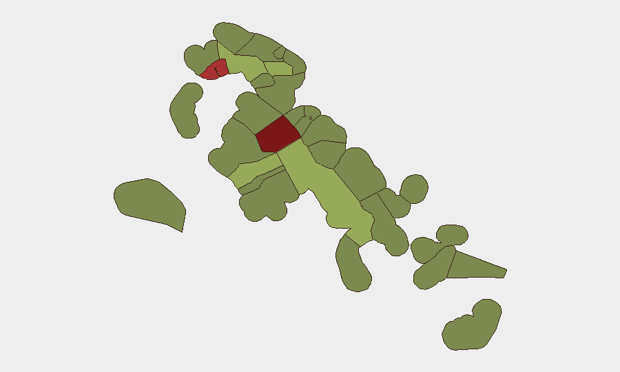
New Providence (risk score 92) and the City of Freeport (risk score 78) dominate the sub-national risk landscape, reflecting high concentrations of street-level gang activity, property crime, and narcotics distribution in Nassau and the Lucayan region. Central Abaco (52), Central Andros (48), and Exuma (45) carry elevated but secondary risk, likely reflecting spillover effects from transshipment routes and smaller urban centers with weaker institutional capacity. Outer islands and Family Islands south and east of Abaco show materially lower risk profiles (28–35), consistent with lower population density and reduced trafficking infrastructure. Corporate security teams with personnel or assets in Nassau or Freeport should maintain heightened baseline protocols; those operating in the outer islands face lower but non-negligible risk.
How GeoBit Would Assist
Security teams operating in the Bahamas should employ AOI Monitoring & Early Warning to maintain persistent watch on high-risk districts in Nassau and Freeport and receive alerts on sudden crowd activity, infrastructure disruptions, or security force movements. Intel Sweep and OSINT fusion (X/Twitter, local media, police and utility feeds, sentiment analysis) enable real-time detection of emerging incidents, unrest, or route-blocking events that could affect personnel or supply chains. Routing & Network Analysis allows duty-of-care teams to plan and update personnel movement routes away from known gang-activity hotspots and to identify alternative transit corridors in advance of operational need.
7-Day Outlook
No major escalation in national security conditions or discrete incidents are forecast for the coming seven days based on open-source signals and historical patterns. Baseline street crime and trafficking-related violence in Nassau and Freeport are expected to persist at current levels without significant concentration or geographic spread. Corporate duty-of-care and security protocols should remain at standard alert posture for high-risk islands, with event-driven escalation contingencies in place should credible reports of civil unrest or infrastructure failure emerge.
Highest-Risk Areas — Ranked
| # | State / Region | Risk |
|---|---|---|
| 1 | New Providence | 92 |
| 2 | City of Freeport | 78 |
| 3 | Central Abaco | 52 |
| 4 | Central Andros | 48 |
| 5 | Exuma | 45 |
| 6 | East Grand Bahama | 42 |
| 7 | South Andros | 38 |
| 8 | North Abaco | 35 |
| 9 | North Eleuthera | 33 |
| 10 | South Abaco | 32 |
| 11 | Cat Island | 30 |
| 12 | Mangrove Cay | 28 |
Sources
Previous Daily Briefs
A new Bahamas brief is written every day — each with its own risk map and downloadable CSV. Here's the last week; use the calendar to go further back.
📅 Browse every day by calendar →
Highlighted days have a brief. Tap a day for that day's map & analysis, or “csv” for that day's dataset ($5).