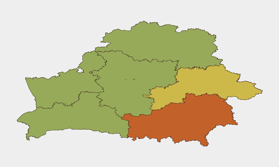
Situation Summary
Belarus remains a contested buffer state between NATO and Russia, with escalating military activity and deepening Russia–Belarus integration creating compounding risk. The last 72 hours show sustained Russian drone transits through Belarusian airspace toward Ukraine, confirmed territorial defence exercises along the southern border, and continued policy-level alignment with Moscow. The overall threat score (10/100) reflects Belarus's position as a transit and staging zone rather than a primary conflict arena, but localized risks in border regions—especially Homyel and Brest—are substantially elevated and warrant sustained monitoring by organizations with personnel or operations in those areas.
Key Developments
- Brest Region (Malaryta & Drahichyn districts), 7–31 July: Territorial defence training is underway in districts adjacent to the Ukrainian border, signaling heightened Belarusian military readiness and possible preparation for broader conflict spillover.
- Belarusian airspace, 6–12 July: Ukrainian monitoring detected 26 Russian drones transiting Belarusian airspace; Belarusian air force scrambled interceptors in response, indicating active surveillance and tactical engagement of Russian unmanned systems.
- Belarusian airspace, 12 July: A Belarusian Mi-24 helicopter shot down a Russian Gerbera strike drone heading toward Ukraine, marking direct Belarusian defensive action against Russian assets—a rare public incident suggesting either improved air-defence coordination or escalating drone traffic.
- Belarus–Ukraine border (official assessment), 12 July: Ukrainian border authorities reported no evidence of Russian strike-force assembly in Belarus as of 12 July, though explicitly cautioned that conditions could deteriorate rapidly.
- National policy, 10 July: Government advanced Union State residence-permit simplification with Russia, underscoring accelerated institutional and administrative integration and reduced barriers to Russian personnel and influence.
- National security coordination, 10 July: Democratic opposition figures (including Tsikhanouskaya) convened a joint security meeting focused on regional escalation and protection of Belarusian sovereignty, reflecting internal political concern over Russian dominance.
Highest-Risk Areas
Homyel Region (risk 75) and Minsk (risk 68) are the primary drivers of Belarus's sub-national risk profile. Homyel's elevation reflects proximity to the Ukraine border, ongoing Russian military activity, and likelihood of cross-border spillover; Minsk's score reflects political volatility, security-force presence, and concentration of government and critical infrastructure. The southern tier—Brest (55), Hrodna (52), and Mahilyow (62)—all show elevated risk tied to military exercises, border proximity, and Russian troop transits. Northern and western regions (Vitsebsk, Minsk Region) remain comparatively stable but not exempt from wider escalation.
How GeoBit Would Assist
Corporate teams in Belarus should deploy AOI Monitoring & Early Warning on Homyel and Brest regions to detect rapid changes in military posture, drone activity, or border incidents. Conflict & Military capabilities—force-structure tracking, weapons-capability mapping, and battle-damage assessment—provide real-time visibility into Belarusian and Russian deployments. OSINT & Intel Sweep (X/Telegram monitoring, Ukrainian and Belarusian official channels, and cross-border reporting) will surface early indicators of escalation or territorial incursion before mainstream reporting, enabling faster duty-of-care response for staff in high-risk zones.
7-Day Outlook
Russian drone activity through Belarus toward Ukraine is likely to persist, with Belarusian interception efforts continuing irregularly. Territorial defence exercises in the south are scheduled through 31 July and will sustain elevated military presence and checkpoint activity. No imminent shift to major cross-border operations is indicated by current intelligence, but the speed of change in this theater warrants continuous real-time monitoring rather than periodic assessment.
Highest-Risk Areas — Ranked
| # | State / Region | Risk |
|---|---|---|
| 1 | Homyel Region | 75 |
| 2 | Minsk | 68 |
| 3 | Mahilyow Region | 62 |
| 4 | Brest Region | 55 |
| 5 | Hrodna Region | 52 |
| 6 | Minsk Region | 48 |
| 7 | Vitsebsk Region | 45 |
Sources
Previous Daily Briefs
A new Belarus brief is written every day — each with its own risk map and downloadable CSV. Here's the last week; use the calendar to go further back.
📅 Browse every day by calendar →
Highlighted days have a brief. Tap a day for that day's map & analysis, or “csv” for that day's dataset ($5).
Atlas — our AI intelligence desk — emails them this snapshot personally. Nothing else, no list.