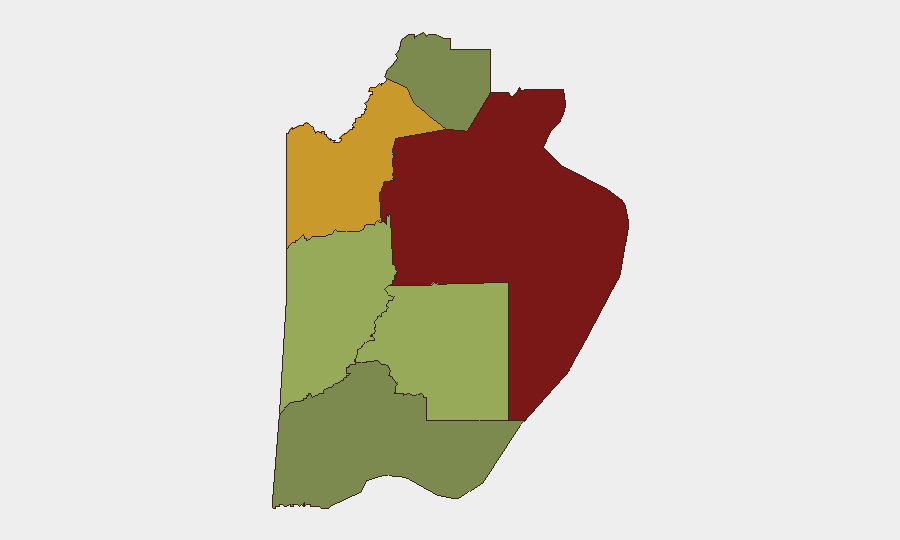
Situation Summary
Belize maintains a stable short-term security posture with no verifiable incidents recorded in the last 24–48 hours, though the country remains classified as a chronically high-crime environment. Gang violence, armed robbery, and rural homicides persist as baseline threats concentrated in urban centers and northern districts, but these reflect structural rather than acute escalation. Current official security operations are assessed as containing flashpoints effectively, with no emerging indicators of sudden deterioration.
Key Developments
- National – 19–20 July 2026: Open-source monitoring across multiple threat platforms documents no discrete, time-stamped security incidents (shootings, protests, major crimes) with reliable attribution in the last 24–48 hours; baseline gang activity remains elevated but unchanged.
- Belize City & Orange Walk District – ongoing through 20 July: Persistent gang violence and armed crime continue as structural threats in these highest-risk zones, with no new trigger events reported in the current 24–48-hour window.
- National – policing & enforcement – as of 18–20 July: Official security policy discussions and gang enforcement operations remain active; current trajectory assessed as "stable" with no new escalation signals.
- Travel advisory status – current as of mid-July: Foreign governments (Australia, US, Canada) maintain "exercise high degree of caution" ratings for violent crime risk but do not flag new incidents or sudden deterioration in the last 24–48 hours.
- Civil unrest – national – last 24–48 hours: No credible reports of new protests or demonstrations; earlier UDP protest activity in Belize City is dated to the first week of July, outside the current window.
Highest-Risk Areas
Belize District (risk score 95) and Orange Walk District (risk score 72) drive national threat ranking, primarily due to concentrated gang activity, armed robbery, and homicide rates in Belize City and surrounding urban corridors. Cayo District (58) presents moderate elevation tied to rural crime and trafficking transit routes. Corozal, Stann Creek, and Toledo districts show significantly lower composite scores (22–48), reflecting lower population density, reduced gang presence, and less organized armed-crime infrastructure. Security teams should weight resource allocation and duty-of-care protocols heavily toward the northern and central urban zones.
How GeoBit Would Assist
Security and risk teams operating in Belize should employ AOI (Area-of-Interest) Monitoring & Early Warning to track Belize City, Orange Walk, and Cayo districts with persistent alerting on gang activity, protests, and crime clusters. Intel Sweep and multi-language OSINT fusion across local media, social platforms, and official sources provide near-real-time corroboration of incidents and early detection of escalation. GIS & Spatial Analysis combined with Network & Actor Analysis enable mapping of gang territories, trafficking routes, and high-risk corridors to inform movement planning and site security posture.
7-Day Outlook
No imminent escalation indicators are present; security conditions are expected to remain stable at current baseline levels of gang violence and armed crime. Monitoring for protest activity, policy shifts in gang enforcement operations, or cross-border trafficking surges should continue as standard precautions. Personnel and asset security protocols should remain calibrated to chronic, not acute, threat levels.
Highest-Risk Areas — Ranked
| # | State / Region | Risk |
|---|---|---|
| 1 | Belize District | 95 |
| 2 | Orange Walk District | 72 |
| 3 | Cayo District | 58 |
| 4 | Stann Creek District | 48 |
| 5 | Toledo District | 35 |
| 6 | Corozal District | 22 |
Sources
Previous Daily Briefs
A new Belize brief is written every day — each with its own risk map and downloadable CSV. Here's the last week; use the calendar to go further back.
📅 Browse every day by calendar →
Highlighted days have a brief. Tap a day for that day's map & analysis, or “csv” for that day's dataset ($5).
Atlas — our AI intelligence desk — emails them this snapshot personally. Nothing else, no list.