Situation Summary
Benin remains a moderate-risk environment (#48 globally) characterized by asymmetric threats concentrated in the Sahel-adjacent north and nascent diplomatic progress with Niger. The country is experiencing a dual dynamic: ongoing jihadist and criminal activity in Alibori and Atakora departments (risk scores 92 and 88 respectively) coinciding with constructive high-level border normalization talks held in Cotonou on 21 June 2026. Current trajectory suggests cautious stabilization in state-level relations, though sub-national security pressures in the north remain elevated and warrant continuous monitoring.
Key Developments
- Cotonou, 21 June 2026 — Benin and Niger held formal high-level talks focused on expedited normalization of bilateral relations, including security and defence cooperation; officials indicated border reopening is a "done deal," signaling a thaw in ties frozen since Niger's 2023 border closure.
- Cotonu, 20–21 June 2026 — Joint expert committees continued working sessions on practical mechanisms for Benin–Niger border reopening and resolution of the bilateral crisis, which has degraded regional trade and security coordination.
- Nationwide, 21 June 2026 — A violent protest or riot was recorded within Benin (precise location and trigger unconfirmed by independent verification); multiple simultaneous military and government disapproval statements issued, suggesting domestic tensions or demonstration activity.
- Government/Military statements, 21 June 2026 — Prime Minister and military leadership issued public statements responding to West Bengal–related developments and internal disapproval signals; political messaging intensity elevated.
- Border region, 21 June 2026 — Benin–Niger diplomatic disagreement flagged by GEOBIT event feed; context consistent with ongoing border crisis but talks indicate de-escalation intent.
*Note: Web research did not independently verify kinetic incidents, major disruptions to commerce, or security emergencies within the last 48 hours beyond diplomatic activity.*
Highest-Risk Areas
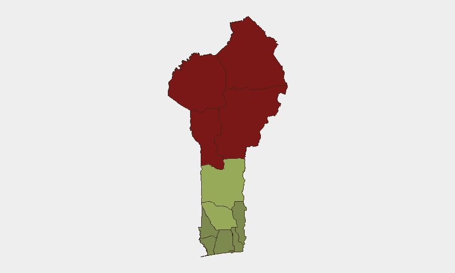
The northern departments of Alibori, Atakora, Donga, and Borgou (composite risk scores 92–83) form a contiguous high-threat belt where jihadist insurgency, transnational criminal networks, and intercommunal tensions drive insecurity. These areas are proximate to Mali and Niger, both afflicted by active Sahel-based militant groups, and serve as transit routes for weapons, narcotics, and displaced populations. Southern coastal departments (Littoral, Ouémé, Atlantique; risk scores 25–22) remain substantially lower-risk and support most commercial and diplomatic activity. Security teams with personnel or assets in the north should prioritize threat monitoring, while southern operations face routine criminal and logistical risk typical of West African coastal zones.
How GeoBit Would Assist
Security and risk teams should deploy AOI Monitoring & Early Warning on Alibori and Atakora departments to receive real-time alerting on militant activity, roadblocks, or recruitment. Network & Actor Analysis combined with OSINT Fusion & Corroboration would track jihadist and trafficking networks operating across Benin–Niger–Mali borders and contextualize diplomatic normalization's impact on security corridors. Conflict & Military battle mapping and GIS & Spatial Analysis enable route risk assessment for personnel and supply movements, particularly critical if the Benin–Niger border reopens.
7-Day Outlook
Diplomatic momentum with Niger is expected to continue through expert-level working committees, likely reducing state-level tensions and supporting eventual border reopening within weeks. Northern insurgent groups are unlikely to be materially affected by diplomatic progress in the near term; threat activity in Alibori and Atakora is forecast to persist at current or elevated levels through summer. Monitoring should remain heightened for spillover from Niger's military instability and any rhetoric linking border reopening to security concessions.
Highest-Risk Areas — Ranked
| # | State / Region | Risk |
|---|---|---|
| 1 | Alibori Department | 92 |
| 2 | Atakora Department | 88 |
| 3 | Donga Department | 85 |
| 4 | Borgou Department | 83 |
| 5 | Zou Department | 45 |
| 6 | Collines Department | 42 |
| 7 | Plateau Department | 38 |
| 8 | Kouffo Department | 35 |
| 9 | Mono Department | 32 |
| 10 | Atlantique Department | 28 |
| 11 | Littoral | 25 |
| 12 | Ouémé Department | 22 |
Sources
Previous Daily Briefs
A new Benin brief is written every day — each with its own risk map and downloadable CSV. Here's the last week; use the calendar to go further back.
📅 Browse every day by calendar →
Highlighted days have a brief. Tap a day for that day's map & analysis, or “csv” for that day's dataset ($5).