Situation Summary
Bhutan remains a low–threat environment globally (composite score 14), with no credible reports of security incidents, civil unrest, or acute instability in the last 24–48 hours from major news outlets or verified social media. Three tracked events—an occupation of territory, a threat to security personnel, and an arrest/detention—occurred on 17–18 June but have not been corroborated in open–source reporting and lack confirmed details on location, parties, or operational impact. The overall security posture remains stable, though border districts show elevated underlying risk exposure.
Key Developments
- No verified new incidents in last 24–48 hours. Open–source coverage does not report active security events, conflict escalation, crime spikes, or travel disruptions across Bhutan as of 19 June 2026.
- Three tracked events (17–18 June) lack open–source confirmation. Internal GeoBit event signals flag an occupation of territory, threats to security personnel, and an arrest/detention, but these have not been independently verified or detailed in major news or X/Twitter reporting. Operational context and location remain unclear.
- Long–term economic pressures persist without acute triggering events. Open sources continue to reference structural vulnerabilities—youth out–migration, fuel–price sensitivity, and development challenges—as background risk factors rather than immediate drivers of incidents.
- No current travel advisories or terrorism/security alerts. International security trackers and regional communiqués do not mention Bhutan–specific threats or advisories as of 19 June 2026.
Highest-Risk Areas
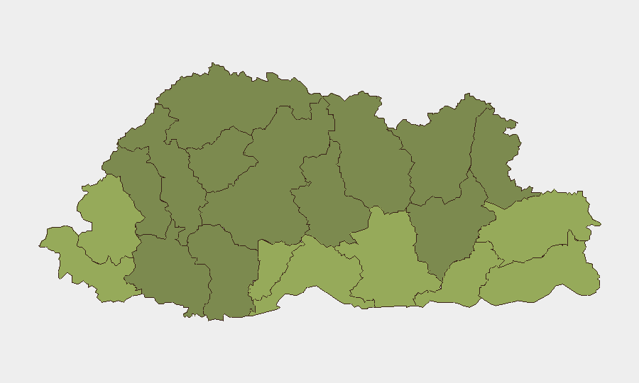
Border districts in southern and eastern Bhutan dominate the sub–national risk ranking. Samtse, Sarpang, Haa, and Pemagatshel districts (scores 58–50) are flagged as the highest–risk zones, likely reflecting proximity to the India–Bhutan border, historical cross–border movement patterns, and remoteness from central authority. Samdrup Jongkhar and Tsirang follow (48 and 45), extending risk concentration along the southern frontier. Central and northern districts (Wangdue Phodrang, Lhuntste, Gasa) register substantially lower scores, suggesting risk is geographically concentrated in peripheral, border–adjacent terrain rather than distributed across the country.
How GeoBit Would Assist
Security teams should deploy AOI (Area–of–Interest) Monitoring & Early Warning on the six highest–risk districts—particularly Samtse and Sarpang—to detect territory occupation, cross–border movement, or detained-person activity in near–real–time. OSINT Fusion (X/Twitter, multi-language search, entity extraction, and sentiment analysis) would corroborate or clarify the three tracked events and distinguish credible incident signals from noise. For duty–of–care planning, Routing & Network Analysis can identify secure transit corridors and alternative pathways away from high–risk zones, while Intel Sweep and ongoing event–feed monitoring will flag any escalation in the 7–day window.
7-Day Outlook
No acute escalation is forecast in the near term; Bhutan's overall stability trajectory remains low–risk. Continued monitoring of the three tracked events (17–18 June) and border–district activity is warranted to confirm whether they reflect operational incidents or data artifacts. Personnel and asset operators in Samtse, Sarpang, and Haa should maintain standard situational awareness protocols pending further clarity on the unverified events.
Highest-Risk Areas — Ranked
| # | State / Region | Risk |
|---|---|---|
| 1 | Samtse District | 58 |
| 2 | Sarpang District | 55 |
| 3 | Haa District | 52 |
| 4 | Pemagatshel District | 50 |
| 5 | Samdrup Jongkhar District | 48 |
| 6 | Tsirang District | 45 |
| 7 | Zhemgang District | 42 |
| 8 | Trashigang District | 40 |
| 9 | Mongar District | 38 |
| 10 | Gasa District | 35 |
| 11 | Lhuntse District | 32 |
| 12 | Wangdue Phodrang District | 30 |
Sources
Previous Daily Briefs
A new Bhutan brief is written every day — each with its own risk map and downloadable CSV. Here's the last week; use the calendar to go further back.
📅 Browse every day by calendar →
Highlighted days have a brief. Tap a day for that day's map & analysis, or “csv” for that day's dataset ($5).