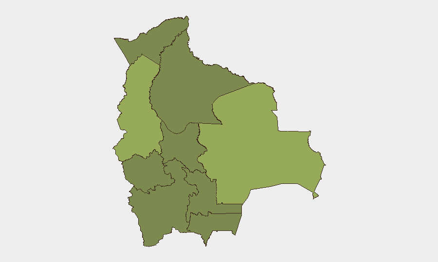
Situation Summary
Bolivia is experiencing a severe escalation in civil unrest, with coordinated road blockades by workers, miners, farmers, and Indigenous groups now affecting approximately 80–100 locations nationwide as of 9–10 June. Armed confrontations between protesters and security forces have resulted in dozens of injuries and at least one police officer in serious condition, with clashes centered in Santa Cruz and along major eastern transport corridors. The government has signaled intent to continue large-scale clearance operations and may invoke emergency powers and military deployment, creating substantial risk of further violence. The threat trajectory is sharply upward.
Key Developments
- San Julián area, Santa Cruz (10 June): Armed clashes between roadblock-manning protesters and Bolivian security forces resulted in dozens of injuries and serious harm to at least one police officer; eyewitness footage documents gunfire and tear gas deployment.
- Major highways, eastern and central Bolivia (10 June): Security forces launched large-scale operations to clear long-running blockades on routes linking Santa Cruz and Cochabamba, triggering violent confrontations in which several police officers sustained gunshot wounds; authorities announced continuation of clearance operations.
- La Paz and El Alto (10 June): Central government held a high-level press conference addressing the security deterioration, ongoing blockades, and economic pressures, signaling tighter security measures and possible additional military or security deployments to restore order in the capital region.
- Nationwide blockade network (9–10 June): Approximately 80–100 road blockades now active across multiple departments, organized by workers, miners, farmers, transport unions, and Indigenous groups; blockades are causing acute shortages of food, medicine, and fuel in La Paz and disrupting intercity travel.
- Chapare region, Cochabamba (9–10 June): Travel advisories now recommend avoidance of all Chapare travel due to an unstable security situation and risk of violent confrontations between security forces and protesters.
- Western Bolivia, including La Paz and Oruro departments (9–10 June): Updated national travel advisories note heightened security conditions with ongoing demonstrations, blockades, and confrontations; advisories flag risk of further deterioration and unpredictable, sudden road closures.
- National level (9–10 June): Government has publicly warned of potential "militarization" of the security response; legislative moves enable declaration of a state of emergency and broader military involvement in internal security operations.
Highest-Risk Areas
Santa Cruz (54.3) and La Paz (51.5) carry composite risk scores substantially above all other departments, driven by the convergence of active armed clashes, large blockade networks, and government security operations underway in both regions as of 10 June. Santa Cruz is the epicenter of violent protester–security force confrontations; La Paz is the seat of government and a focal point for capital-region unrest and supply-chain disruption. Cochabamba (34.4) ranks third, reflecting the Chapare instability and the strategic importance of the Santa Cruz–Cochabamba corridor in the ongoing clearance operations. The remaining departments (Potosí, Tarija, Pando, Beni, Oruro, Chuquisaca) carry elevated but lower risk, though western regions show signs of spillover activity.
How GeoBit Would Assist
Security and duty-of-care teams should deploy AOI Monitoring & Early Warning capabilities on Santa Cruz, La Paz, and the Chapare region to detect emerging roadblock activity, protest scaling, and security force deployments in near-real time. Routing & Network Analysis can identify alternative transport corridors and supply-chain pathways around active blockades and conflict zones. OSINT Fusion (X/Twitter, Telegram, YouTube, and multi-language search) combined with sentiment and temporal analysis will track escalation signals from protest organizers, security agencies, and government statements to enable advance workforce notification and movement planning.
7-Day Outlook
Road blockades are likely to persist or expand absent negotiated settlement, and security force clearance operations will probably continue, creating sustained risk of armed confrontations and casualties. If the government invokes emergency powers or significantly escalates military deployment, violence may intensify, with spillover disruption to transportation and essential services across western and central Bolivia. The window for voluntary evacuation or route alteration for non-essential personnel remains open but is narrowing.
Highest-Risk Areas — Ranked
| # | State / Region | Risk |
|---|---|---|
| 1 | Santa Cruz | 54.3 |
| 2 | La Paz | 51.5 |
| 3 | Cochabamba | 34.4 |
| 4 | Potosí | 25.2 |
| 5 | Tarija | 24.3 |
| 6 | Pando | 24.3 |
| 7 | Beni | 24.3 |
| 8 | Oruro | 24.3 |
| 9 | Chuquisaca | 24.3 |
Sources
Previous Daily Briefs
A new Bolivia brief is written every day — each with its own risk map and downloadable CSV. Here's the last week; use the calendar to go further back.
📅 Browse every day by calendar →
Highlighted days have a brief. Tap a day for that day's map & analysis, or “csv” for that day's dataset ($5).