Situation Summary
Brunei remains in a stable security posture with no verified incidents, civil unrest, conflict, crime spikes, or infrastructure disruptions reported in the last 24–48 hours. The country's overall threat environment is characterised as low, with routine administrative and diplomatic activity proceeding normally. No travel warnings, protest activity, or terrorism-related events have been flagged by official channels or open-source monitoring in the current reporting window.
Key Developments
- National – 2–3 August 2026 – No discrete security, conflict, crime, civil-unrest, or infrastructure incidents verified in the last 24–48 hours. Internal security remains stable with normal governance and administrative operations continuing across all districts.
- National – 2–3 August 2026 – No active travel warnings, public protest activity, or operational disruptions reported. Travel-risk posture remains low with no barriers to routine business and personal mobility.
- National – 2–3 August 2026 – No terrorism-related security events, arrests, or plot activity documented in recent official communications or monitoring feeds. Standing national concern regarding terrorism threats remains unchanged; no new indicators have emerged.
- National – 2–3 August 2026 – No infrastructure disruption, power outages, transport failures, major accidents, or industrial incidents reported. Critical services and utilities are operating at baseline capacity.
- National – 2–3 August 2026 – Routine diplomatic and bilateral engagement continuing. No signs of political instability or imminent destabilization in latest country-level briefings.
Highest-Risk Areas
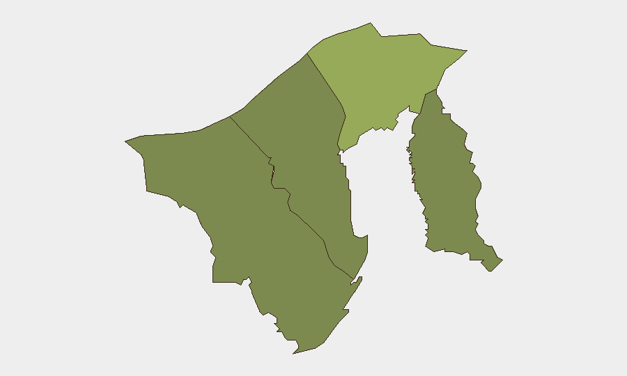
Brunei-Muara District (composite risk score 45) accounts for the plurality of sub-national risk concentration, reflecting Bandar Seri Begawan's status as the capital, primary commercial hub, and seat of government. Tutong District (risk 20) and Belait District (risk 15) register secondary but material risk profiles, likely reflecting petrochemical infrastructure, industrial facilities, and transport corridors. Temburong District (risk 10) presents the lowest quantified risk. Risk elevation in the higher-scoring districts reflects routine exposure density (population, critical infrastructure, international business presence) rather than acute incident activity in the current window.
How GeoBit Would Assist
Intel Sweep and OSINT fusion would sustain real-time monitoring of official Brunei government and police communications, regional diplomatic traffic, and open-source feeds to detect emerging incidents or threat signals before they escalate. AOI Monitoring & Early Warning with persistent watch on Brunei-Muara District and key infrastructure nodes (ports, airport, energy facilities) would trigger alerts on crowd activity, security force mobilisation, or infrastructure anomalies. GIS & Spatial Analysis would support contingency routing and movement planning for personnel and assets across high-risk and lower-risk districts, enabling rapid alternative-route identification if localised disruptions occur.
7-Day Outlook
Brunei's security environment is forecast to remain stable over the next seven days with no indicators of acute escalation, civil unrest, or major incident activity. Routine monitoring protocols should remain in effect; no change to duty-of-care posture or operational tempo is warranted based on current threat signals. Regular surveillance of diplomatic channels, police communications, and infrastructure status should continue to provide early warning of any material shift.
Highest-Risk Areas — Ranked
| # | State / Region | Risk |
|---|---|---|
| 1 | Brunei-Muara District | 45 |
| 2 | Tutong District | 20 |
| 3 | Belait District | 15 |
| 4 | Temburong District | 10 |
Sources
Previous Daily Briefs
A new Brunei brief is written every day — each with its own risk map and downloadable CSV. Here's the last week; use the calendar to go further back.
📅 Browse every day by calendar →
Highlighted days have a brief. Tap a day for that day's map & analysis, or “csv” for that day's dataset ($5).
Atlas — our AI intelligence desk — emails them this snapshot personally. Nothing else, no list.