Situation Summary
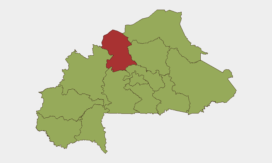
Burkina Faso remains at composite threat level #28 globally with significant sub-national concentration of risk in the North region (78.3), while 11 other regions cluster at moderate elevation (48.3). The security environment is shaped by ongoing armed group activity, particularly in the Sahel-bordering North and Upper-Basins zones, combined with domestic institutional tensions reflected in recent high-profile legal proceedings. No imminent nationwide destabilization is signaled, but the North's threat score substantially exceeds the national average, indicating localized but acute exposure.
Key Developments
- Ouagadougou, June 2026 — Former presidential security chief Captain Abdel Kader Zanri sentenced to 11 years imprisonment on arson and endangerment charges related to destruction of activist property; case carries political sensitivity and reflects ongoing institutional accountability proceedings.
- Nationwide, June 2026 — Multiple public statements and investigative actions by Coast Guard, Prosecutor, Authorities, and legal representatives signal active law-enforcement engagement; specific targets and charges remain under investigation but indicate active state institutional response to criminal or security matters.
- June 4–5, 2026 — Arrest/detention actions recorded against BAHAMA entity; underlying charges and context not yet clarified in available reporting but flagged as investigative priority by security authorities.
- Nationwide, June 4–5, 2026 — Multiple public statements issued by Prosecutor, Coast Guard, Authorities, Attorney, and Lawyer indicate coordinated or sequential institutional response; suggests either major criminal investigation or security enforcement action in early disclosure phase.
Note: Last-24–48-hour open-source reporting is insufficient to isolate granular incident detail (location, time, casualty count, tactical dynamics). GEOBIT event signals confirm elevated institutional activity but do not yet expose underlying threat drivers. Verification against secondary sources is pending.
Highest-Risk Areas
The North region's risk score of 78.3—nearly 60% above the national average—reflects persistent armed group presence, ongoing insurgent activity, and limited state administrative control. Upper-Basins and the cluster of Central, Sahel, East, and peripheral regions at 48.3 indicate secondary risk concentration across the Sahel-prone belt and central administrative zone. The North's isolation in risk severity underscores that security planning for Burkina Faso must prioritize this zone for asset protection, staff movement restrictions, and contingency planning; southern and central regions present moderate but non-negligible exposure. The disparity suggests two-tier risk management (high-constraint North operations; standard protocols elsewhere) is warranted.
How GeoBit Would Assist
Security teams should deploy AOI Monitoring & Early Warning on the North region with persistent alert thresholds for armed group movement, IDP flows, and checkpoint activity. Multi-language OSINT fusion (X/Twitter, Telegram, radio SIGINT) and conflict & military tracking will resolve current gaps in incident detail and map force disposition. Routing & Network Analysis enables real-time alternative route planning for personnel and supply movement, critical in the North's constrained environment.
7-Day Outlook
Institutional law-enforcement and investigative tempo is elevated, suggesting either imminent charges or charges already filed; public disclosure may clarify threat exposure in the coming 48–72 hours. Armed group activity in the North is likely to persist at current operational tempo; no scaling indicators are present but northern movement should be assumed high-risk. Monitor for any spillover of institutional tension or detention actions into secondary regions, which could signal broader security unraveling.
Highest-Risk Areas — Ranked
| # | State / Region | Risk |
|---|---|---|
| 1 | North | 78.3 |
| 2 | Upper-Basins | 48.3 |
| 3 | Boucle du Mouhoun | 48.3 |
| 4 | Central-West | 48.3 |
| 5 | Central-South | 48.3 |
| 6 | Central-East | 48.3 |
| 7 | Waterfalls | 48.3 |
| 8 | Southwest | 48.3 |
| 9 | Sahel | 48.3 |
| 10 | Central-North | 48.3 |
| 11 | East | 48.3 |
| 12 | Centre | 48.3 |
Previous Daily Briefs
A new Burkina Faso brief is written every day — each with its own risk map and downloadable CSV. Here's the last week; use the calendar to go further back.
📅 Browse every day by calendar →
Highlighted days have a brief. Tap a day for that day's map & analysis, or “csv” for that day's dataset ($5).