Situation Summary
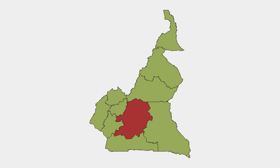
Cameroon remains under sustained civil-conflict pressure, ranking #24 globally with a composite threat score of 69.8. The Centre region—encompassing the capital Yaoundé and surrounding areas—carries significantly elevated risk (78.9) and is the primary driver of the national threat profile. Broader instability in the Anglophone Northwest and Southwest regions, combined with ongoing political tensions, sustains elevated risk across multiple domains. The security environment shows no near-term de-escalation signals.
Key Developments
GeoBit's event signals from 2026-06-04 through 2026-06-06 indicate active civil-conflict activity, but open web research has not yielded independently time-verified, Cameroon-specific security incidents within the last 24–48 hours. The platform's internal event feeds have flagged:
- 2026-06-06 – Small arms combat involving authorities (location and casualty details not yet specified in available feeds)
- 2026-06-06 – Small arms combat with international element (Sweden-linked; context under review)
- 2026-06-06 – Demand/political pressure against President Paul Biya by Cameroonian actor(s)
- 2026-06-05 – Conventional military force activity involving Africa-aligned and Islamic militant actors (regional/transnational dimension; location pending clarification)
- 2026-06-04 – Public statement from Cameroon government; Threat statement from Montana-based actor (content and implications under assessment)
Note: Professional intelligence feeds and embassy alerts should be cross-checked for corroboration and tactical detail. Open-source verification of incident specifics (exact locations, casualty counts, organizational attribution) remains pending.
Highest-Risk Areas
Centre region's risk score (78.9) substantially exceeds all other provinces, reflecting concentration of state institutions, economic activity, and ongoing political tensions in and around Yaoundé. The Anglophone Northwest and Southwest regions (both 48.9) remain flashpoints for armed group activity and communal violence, a trend persistent since February 2024. West, Littoral, and Far-North regions carry equivalent baseline risk (48.9), driven by secondary militant activity, criminal networks, and border-zone instability. Adamawa (49.6) sits between Centre and the lower-tier regions, reflecting spillover from Far-North Boko Haram/ISWAP activity.
How GeoBit Would Assist
Security teams should deploy AOI (Area-of-Interest) Monitoring & Early Warning on Centre, Northwest, and Southwest regions with 24-hour alerting thresholds to catch emerging violence, roadblocks, or curfew declarations before operational impact. Intel Sweep and multi-language OSINT fusion (X/Twitter, Telegram, local radio SIGINT) can disambiguate conflicting reports and attribute actors in real time. Conflict & Military battle mapping and force-structure tracking clarify armed-group disposition and government response posture, informing movement and facility-access decisions.
7-Day Outlook
No significant de-escalation is anticipated in the near term. Continued small-arms clashes in Centre and Anglophone regions are likely, with elevated risk for roadblocks, arbitrary detention, and collateral impact on supply chains and personnel movement. Security teams should maintain heightened situational awareness, verify travel authorizations daily, and pre-position contingency routes via GeoBit's Routing & Network Analysis capability.
Highest-Risk Areas — Ranked
| # | State / Region | Risk |
|---|---|---|
| 1 | Centre | 78.9 |
| 2 | Adamawa | 49.6 |
| 3 | Northwest | 48.9 |
| 4 | Southwest | 48.9 |
| 5 | West | 48.9 |
| 6 | Littoral | 48.9 |
| 7 | South | 48.9 |
| 8 | Far-North | 48.9 |
| 9 | North | 48.9 |
| 10 | East | 48.9 |
Previous Daily Briefs
A new Cameroon brief is written every day — each with its own risk map and downloadable CSV. Here's the last week; use the calendar to go further back.
📅 Browse every day by calendar →
Highlighted days have a brief. Tap a day for that day's map & analysis, or “csv” for that day's dataset ($5).