Situation Summary
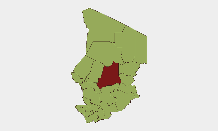
Chad remains at moderate global risk (#29 globally, composite threat score 72) with significant sub-national variation. Batha State presents substantially elevated threat levels (80.4), while twelve other regions cluster at elevated risk (50.4 each). Recent event signals point to arrest/detention activity and civil demonstrations, though current operational impact and scale remain unclear. The overall trajectory suggests a fluid but not acute national security environment as of mid-June 2026.
Key Developments
Reporting Limitations: GeoBit's live web research (last 24–48 hours) has not returned corroborated, location-specific security incidents in Chad with independent source confirmation. Event signals in the platform indicate arrests and demonstrations logged on 12–13 June, but verification of precise location, nature, and operational significance is incomplete. Until multi-source confirmation is available for incidents within Chad's borders on these dates, specific operational developments cannot be reliably presented. Security teams should cross-reference specialist regional feeds (ACLED, Crisis24, UN OCHA, French-language Sahel outlets such as RFI Afrique and Alwihda Info) for real-time incident corroboration.
Highest-Risk Areas
Batha State dominates the risk profile with a composite score of 80.4—significantly higher than all other regions—indicating concentrated instability. The remaining eleven high-risk zones (Ennedi-Ouest, Wadi Fira, Ouaddaï, Sila, Salamat, East Ennedi, Kanem, Lac, N'Djamena, Hadjer-Lamis, and Chari-Baguirmi) score at 50.4, suggesting either shared underlying drivers or similar exposure to armed-group activity, intercommunal tension, or governance challenges. The spread of elevated risk across the north, east, and southern regions—including the capital N'Djamena—indicates that threat exposure is geographically diffuse rather than localized. Organizations with operations or personnel in Batha require heightened vigilance; those in secondary risk zones should maintain standard security protocols and event monitoring.
How GeoBit Would Assist
Area-of-Interest (AOI) Monitoring & Early Warning enables persistent watch on high-risk regions (particularly Batha, Lac, and N'Djamena) with real-time alerting tied to movement, communications, or incident signals. Conflict & Military mapping combined with Network & Actor Analysis allows security teams to track armed-group positioning, force-structure changes, and leadership dynamics across the sub-national landscape. Multi-language OSINT (Intel Sweep, X/Twitter & Telegram monitoring, French-language Sahel news analysis) and temporal sentiment analysis provide early warning of emerging tensions, protest movements, or governance instability before they escalate to direct security impact.
7-Day Outlook
Near-term trajectory suggests continuation of current elevated baseline with possible minor fluctuations in arrest and demonstration activity. No indicators of imminent large-scale armed escalation or state collapse are evident in available signals; however, Batha's outlier risk score warrants close monitoring for indicators of localized conflict or displacement. Security teams should maintain heightened readiness in high-risk zones and refresh contingency routing and personnel protocols by end of week.
Highest-Risk Areas — Ranked
| # | State / Region | Risk |
|---|---|---|
| 1 | Batha | 80.4 |
| 2 | Ennedi-Ouest | 50.4 |
| 3 | Wadi Fira | 50.4 |
| 4 | Ouaddaï | 50.4 |
| 5 | Sila | 50.4 |
| 6 | Salamat | 50.4 |
| 7 | East Ennedi | 50.4 |
| 8 | Kanem | 50.4 |
| 9 | Lac | 50.4 |
| 10 | N'Djamena | 50.4 |
| 11 | Hadjer-Lamis | 50.4 |
| 12 | Chari-Baguirmi | 50.4 |
Sources
Previous Daily Briefs
A new Chad brief is written every day — each with its own risk map and downloadable CSV. Here's the last week; use the calendar to go further back.
📅 Browse every day by calendar →
Highlighted days have a brief. Tap a day for that day's map & analysis, or “csv” for that day's dataset ($5).