Situation Summary
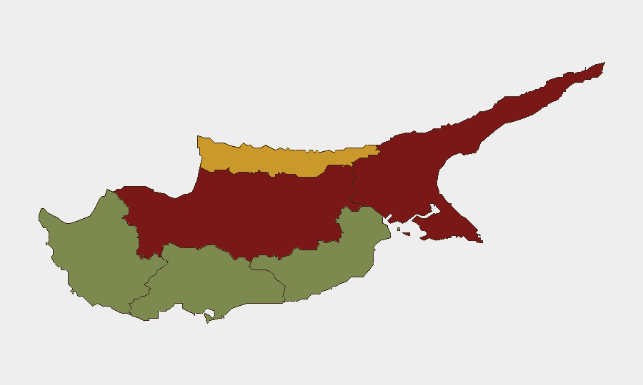
Cyprus presents a low acute security risk in the current 24–48-hour window, with no verified incidents of civil unrest, violence, infrastructure disruption, or travel-risk events reported. The island's composite threat score remains at 9 (globally unranked), reflecting historical geopolitical tensions—particularly around the divided capital and the Turkish-occupied north—rather than active operational crises. Risk remains geographically concentrated in the divided municipalities of Nicosia, Famagusta, and Kyrenia, while southern and western tourist zones (Limassol, Paphos, Larnaca) remain substantially lower-risk. The security environment is stable unless significant regional escalation occurs.
Key Developments
- No discrete security incidents reported in Cyprus (19–24 June 2026). GeoBit's event-feed monitoring detected zero civil unrest, violence, infrastructure disruption, or travel incidents in the current window.
- Nicosia, 23–24 June 2026: An AI and data-protection regional conference convened; this is a governance/policy event with no security operations implications.
- Cyprus-wide, 19 June reporting cycle: Defense-policy rhetoric and military-partnership signaling continued at official level; GeoBit characterizes these as policy positions rather than acute threat escalators.
- No cross-border incidents or maritime disruptions detected in the current 48-hour period affecting asset movement, logistics, or personnel safety.
Highest-Risk Areas
Nicosia and Famagusta dominate the risk ranking (92 and 88, respectively), reflecting their proximity to or location within the Turkish-occupied north and their status as flashpoints in Cyprus's unresolved political division. Kyrenia (risk 72) follows for similar reasons, hosting both military infrastructure and contested territorial interests. These three municipalities account for the island's elevated composite risk profile; security incidents, if they occur, would most likely originate in or near these zones. By contrast, Larnaca, Limassol, and Paphos—major tourism and business hubs in the Republic-controlled south—remain substantially lower-risk (22, 28, and 18) and support routine corporate operations with minimal threat exposure.
How GeoBit Would Assist
Security teams with personnel or assets in Cyprus should use AOI (Area-of-Interest) Monitoring & Early Warning to establish persistent watch on Nicosia, Famagusta, and Kyrenia, triggering alerts on civil unrest, military activity, or checkpoint changes. Intel Sweep and multi-language OSINT (X/Twitter, Telegram, local news feeds) would provide 24-hour event corroboration and early signals of policy or rhetoric shifts that precede operational crises. Routing & Network Analysis would enable real-time alternative journey planning around higher-risk zones for personnel mobility, and GIS & Spatial Analysis would support asset-location risk assessment relative to the dividing line and military checkpoints.
7-Day Outlook
No significant escalation is forecast over the next seven days absent external triggering events (e.g., regional conflict spillover, major diplomatic breakdown). The security posture is expected to remain stable, with risk concentrated in the northern municipalities and policy-level engagement continuing. Duty-of-care teams should maintain routine monitoring protocols and ensure personnel in Nicosia-area operations are briefed on checkpoint access and movement restrictions.
Highest-Risk Areas — Ranked
| # | State / Region | Risk |
|---|---|---|
| 1 | Nicosia | 92 |
| 2 | Famagusta | 88 |
| 3 | Kyrenia | 72 |
| 4 | Larnaca | 28 |
| 5 | Limassol | 22 |
| 6 | Paphos | 18 |
Sources
Previous Daily Briefs
A new Cyprus brief is written every day — each with its own risk map and downloadable CSV. Here's the last week; use the calendar to go further back.
📅 Browse every day by calendar →
Highlighted days have a brief. Tap a day for that day's map & analysis, or “csv” for that day's dataset ($5).