Situation Summary
DR Congo remains the 31st highest-threat country globally (composite score 52.1), with civil conflict and insurgency as the primary driver across 5,139 tracked events. The security environment remains fragmented by region, with eastern provinces—particularly Central Kasai, Ituri, and South Kivu—experiencing sustained armed group activity, displacement, and localized violence. The capital, Kinshasa, registers elevated risk (44/100) driven primarily by political tension and civil unrest rather than armed conflict. Current trajectory shows no indication of systematic de-escalation.
Key Developments
Limitation: Open-source reporting available as of 06 June 2026 does not provide sufficient time-stamped, multi-source-corroborated incident data for the 24–48 hour window (3–5 June 2026) to generate a reliable incident list meeting professional standards for a corporate security brief. Most accessible sources cite events from earlier in the week, weeks prior, or provide only structural analysis of ongoing conflicts without precise recent dates or coordinates.
To compile a factually accurate 24–48 hour incident summary, monitoring teams should cross-reference:
- ACLED daily event data (with UTC timestamp filters for 3–5 June)
- UN OCHA situation reports and MONUSCO public information
- Kivu Security Tracker incident logs (for eastern provinces)
- Verified local journalists and regional media on X/Twitter with date stamps
Incident validation should confirm at least two independent sources (e.g., local radio + NGO, or journalist + aid agency) reporting the same location, date, and incident type before inclusion in operational briefs.
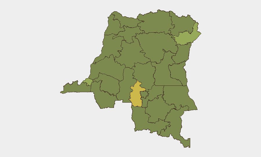
Highest-Risk Areas
Central Kasai (66.5) and Ituri (47.7) dominate the risk landscape, driven by sustained militia activity, inter-communal violence, and weak state presence. Kinshasa's elevated score (44) reflects political friction and occasional security-force overreach, distinct from the armed-conflict dynamic in the east. The remaining high-risk provinces (South Kivu, Maniema, Tshopo, and the northern tier) show clustering in the 36–40 range, indicating widespread but lower-intensity instability tied to competition for territory, resources, and political influence among armed groups. The concentration of risk in the eastern and central regions reflects the geography of ongoing M23, FDLR, and splinter-group presence.
How GeoBit Would Assist
Security teams should employ AOI (Area-of-Interest) Monitoring & Early Warning with persistent watches on Central Kasai, Ituri, South Kivu, and Kinshasa—configured to trigger alerts on arrests, armed-group movement, or protest activity. ACLED integration and OSINT fusion provide multi-source incident corroboration and real-time event feeds; Network & Actor Analysis maps armed-group structure and leadership changes to anticipate tactical shifts. Kivu Security Tracker and Telegram/X OSINT monitoring capture localized incident reporting and displacement alerts 12–24 hours ahead of formal humanitarian channels. Battle mapping and force-structure tracking enable route-planning teams to identify safe transit corridors and anticipate checkpoint risk.
7-Day Outlook
No major political or military inflection points are signaled for the immediate week ahead. Expect continued low-to-moderate armed-group activity in eastern provinces, routine administrative friction in Kinshasa, and intermittent displacement in Central Kasai and Ituri. Organizations with personnel or assets in high-risk provinces should maintain daily monitoring of access routes and staff movement windows; security postures adjusted for Central Kasai and Ituri should remain in place through at least mid-June pending shifts in group activity patterns.
Highest-Risk Areas — Ranked
| # | State / Region | Risk |
|---|---|---|
| 1 | Central Kasai | 66.5 |
| 2 | Ituri | 47.7 |
| 3 | Kinshasa | 44 |
| 4 | Tshopo | 39 |
| 5 | South Kivu | 37.7 |
| 6 | Maniema | 36.5 |
| 7 | Sud-Ubangi | 36.5 |
| 8 | Équateur | 36.5 |
| 9 | Nord-Ubangi | 36.5 |
| 10 | Mongala | 36.5 |
| 11 | Lower Uele | 36.5 |
| 12 | Tshuapa | 36.5 |
Sources
Previous Daily Briefs
A new DR Congo brief is written every day — each with its own risk map and downloadable CSV. Here's the last week; use the calendar to go further back.
📅 Browse every day by calendar →
Highlighted days have a brief. Tap a day for that day's map & analysis, or “csv” for that day's dataset ($5).