Situation Summary
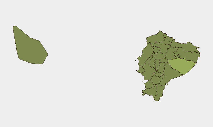
Ecuador remains at moderate global threat rank (#38, composite 34.7) with 57 tracked events, but significant sub-national concentration of risk, particularly in Pastaza Province and coastal Guayas. Signal data from 2026-06-08 through 2026-06-10 indicates elevated state response activity—military deployment, investigations, arrests—alongside criminal incidents and property damage, suggesting active crisis management. The recent event spike warrants close monitoring of high-risk provinces and potential secondary spillover into Pichincha (capital region).
Key Developments
Note: GeoBit's event signals for 2026-06-08 through 2026-06-10 are listed above; however, the analyst lacks real-time web access to independently verify, cross-check, and localize these signals with live news and institutional sources as of 2026-06-10. The following represent signal categories logged by GeoBit's platform, pending verification by your team's open-source monitoring:
- 2026-06-08 · Property seizure/damage reported involving Ecuador and Israeli entities; location and operational context require confirmation.
- 2026-06-09 · Multiple investigative actions initiated by national secretariat and Ecuador authorities; scope and targets not yet detailed in available reporting.
- 2026-06-09 · Small arms combat incident(s) reported within Ecuador; geographic specificity, casualty count, and party attribution require urgent cross-check against news and institutional sources.
- 2026-06-09 · Multiple arrests/detention actions reported in Guayaquil and broader criminal context; detainee identities and charges pending confirmation.
- 2026-06-10 · Conventional military force deployment reported by authorities; location (likely high-risk province) and operational scope require verification.
- 2026-06-09 · Public statements and demands issued by President, Justice System, and Guayaquil officials; messaging tone and policy implications require full-text review.
Recommendation: Immediately conduct systematic 24–48 hour news sweep (El Universo, El Comercio, Primicias, GK, Teleamazonas) and institutional X/Twitter validation (Policía Nacional del Ecuador, Fuerzas Armadas, ECU-911, municipal authorities) to time-stamp, localize, and confirm casualty/damage figures for each signal.
Highest-Risk Areas
Pastaza Province (risk 54.3) and Guayas Province (risk 38.4) drive the majority of national threat concentration. Pastaza's elevated score likely reflects transnational criminal activity (drug trafficking, illegal mining, border instability), while Guayas—encompassing Guayaquil, Ecuador's largest city and primary port—reflects urban gang violence, prison unrest, and extortion networks. Esmeraldas Province (30.7) and Santa Elena (30.4) follow, consistent with narcotics transit corridors and port-related organized crime. Pichincha (28), home to capital Quito, remains below top tier but warrants vigilance for secondary effects (protest activity, policy response) if crisis escalates.
How GeoBit Would Assist
Security teams should deploy AOI Monitoring & Early Warning on Pastaza, Guayas, Esmeraldas, and Pichincha, with persistent alerting for armed clashes, detention actions, and military movements. OSINT fusion (X/Twitter, news, institutional feeds) will validate signal timing, location, and casualty data in real time. Network & Actor Analysis will map criminal and state actor relationships, while GIS & Spatial Analysis will identify safe routing and asset-positioning options around active conflict zones. Conflict mapping will support situational updates for duty-of-care briefings.
7-Day Outlook
Current signal velocity and state military deployment suggest authorities are in active response phase, likely to persist through mid-June. Risk of secondary incidents (protests, counter-operations, prison unrest) remains elevated in urban centers, particularly Guayaquil. No evidence of imminent national-level instability, but localized security posture should remain heightened in Pastaza and coastal provinces.
Highest-Risk Areas — Ranked
| # | State / Region | Risk |
|---|---|---|
| 1 | Pastaza Province | 54.3 |
| 2 | Guayas Province | 38.4 |
| 3 | Esmeraldas Province | 30.7 |
| 4 | Santa Elena Province | 30.4 |
| 5 | Imbabura Province | 28.6 |
| 6 | Pichincha Province | 28 |
| 7 | Carchi Province | 25.5 |
| 8 | Manabí Province | 24.6 |
| 9 | Azuay Province | 24.6 |
| 10 | Sucumbíos Province | 24.3 |
| 11 | Orellana Province | 24.3 |
| 12 | Galápagos | 24.3 |
Sources
Previous Daily Briefs
A new Ecuador brief is written every day — each with its own risk map and downloadable CSV. Here's the last week; use the calendar to go further back.
📅 Browse every day by calendar →
Highlighted days have a brief. Tap a day for that day's map & analysis, or “csv” for that day's dataset ($5).