Situation Summary
Egypt remains a moderate-risk jurisdiction (rank 21 globally, composite score 70) with persistent but localized security pressures centered on Cairo and the Sinai Peninsula. Recent open-source reporting does not indicate acute incidents or escalation in the 24–48 hours ending 13 June 2026; however, regional diplomatic activity (Egypt's role in Middle East ceasefire facilitation) and economic strain from reduced Suez Canal revenues continue to shape the threat environment. Airspace remains open and commercial operations proceed normally. The security picture is characterized by steady, geographically dispersed risks rather than sudden systemic deterioration.
Key Developments
Limited acute incident reporting: Open-source corroboration for Egypt-specific security incidents dated 11–13 June 2026 remains sparse. Verified reporting on terrorism, large-scale unrest, criminal events, or infrastructure disruptions in that window was not available from major international, regional, or specialist outlets at time of research.
Regional geopolitical positioning (10 June, Cairo / UN): Egypt was cited by the UN Secretary-General as a key state facilitating Middle East diplomatic efforts alongside the US, Qatar, and Türkiye. No domestic unrest or anti-government protests linked to this role were reported; the activity reflects Egypt's ongoing mediation stance rather than a domestic security incident.
Economic/Suez Canal context (12 June, nationwide): Regional analysis confirmed reduced Suez Canal revenues due to ongoing regional conflict, increasing economic pressure on Egypt. No new attacks, sabotage, or operational disruptions to the Canal were reported in the immediate 24–48-hour window.
Diplomatic/military posturing (11 June, regional signals): GeoBit event signals flagged conventional military force statements involving Israel, Britain, and France in relation to Egypt, alongside a small-arms incident involving a worker. These signals lack current open-source corroboration of active combat or defined incidents within Egypt's territory as of 13 June.
Highest-Risk Areas
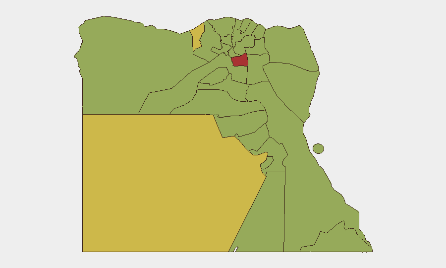
Cairo dominates the risk profile (79.2), reflecting its size, political salience, and concentration of security incidents. Alexandria (62.8) and the New Valley governorate (60.9) follow, with secondary concern across Sinai variants (North, South: 49.2 each) and the Suez Canal zone (53.4). Mainland urban centers—particularly Cairo—drive national risk; Sinai's ranking reflects chronic but lower-frequency militant activity. Red Sea and Eastern governorates (both 49.2) warrant monitoring due to maritime exposure and border dynamics, though current incident reporting does not show acute degradation.
How GeoBit Would Assist
Security teams should employ Intel Sweep and multi-language OSINT (X/Twitter, Telegram, media feeds) to maintain 24-hour visibility on Cairo and Alexandria protest/riot activity, and AOI Monitoring with persistent alerting on Sinai insurgent activity, Suez Canal maritime incidents, and economic/labor unrest. Conflict & Military tracking and force-structure intelligence would support monitoring of Israel-Egypt and UK/France military posturing. Satellite & Imagery analysis and GIS/spatial monitoring enable real-time assessment of Suez operations and infrastructure integrity.
7-Day Outlook
No indicators of imminent major attack, coup, or nationwide unrest are present in current reporting. Economic headwinds (Suez revenue, broader regional conflict) will likely persist but are unlikely to trigger sudden political instability within seven days. Monitoring should remain focused on Sinai-based insurgent activity, Cairo labor/political protests, and any escalation in Israel-Egypt or regional military signaling.
Highest-Risk Areas — Ranked
| # | State / Region | Risk |
|---|---|---|
| 1 | Cairo | 79.2 |
| 2 | Alexandria | 62.8 |
| 3 | New Valley | 60.9 |
| 4 | Suez | 53.4 |
| 5 | Ad Dakahliya | 52 |
| 6 | Suhaj | 50.1 |
| 7 | Damietta | 49.7 |
| 8 | Eastern | 49.7 |
| 9 | North Sinai | 49.2 |
| 10 | Qena | 49.2 |
| 11 | South Sinai | 49.2 |
| 12 | Red Sea | 49.2 |
Sources
Previous Daily Briefs
A new Egypt brief is written every day — each with its own risk map and downloadable CSV. Here's the last week; use the calendar to go further back.
📅 Browse every day by calendar →
Highlighted days have a brief. Tap a day for that day's map & analysis, or “csv” for that day's dataset ($5).