Situation Summary
Equatorial Guinea maintains a composite threat ranking of 5 globally (#155), reflecting a relatively stable macro-security environment without major active conflicts, large-scale civil unrest, or recent terrorist incidents. No discrete security incidents—protests, violence, infrastructure failures, or sudden political moves—were reliably documented in open sources or social media during the past 24–48 hours. The country's baseline risk profile remains shaped by longstanding structural factors: authoritarian governance, documented human-rights concerns (arbitrary detention, torture, corruption), and regional maritime-trafficking pressures, particularly in northern provinces. No new triggers have emerged to materially alter near-term threat trajectory.
Key Developments
No discrete security incidents meeting recency and corroboration criteria (specific incident, dated source, multi-outlet confirmation) were identified in the last 24–48 hours. Open-source reporting, X/Twitter feeds, and social media show no documented protests, clashes, arrests, infrastructure disruptions, or diplomatic ruptures with a clear 2026-07-07 to 2026-07-09 timestamp. A single unverified Facebook post referenced potential French Embassy seizure and diplomat expulsion, but carried no visible date, timestamp, or corroborating news coverage and cannot be safely attributed to the current 48-hour window. Standard consular and routine governmental communications were visible but do not constitute incident-level developments. Absence of reportage should not be misread as absence of risk; rather, it indicates no major triggering events have breached local and international media thresholds in this short window.
Highest-Risk Areas
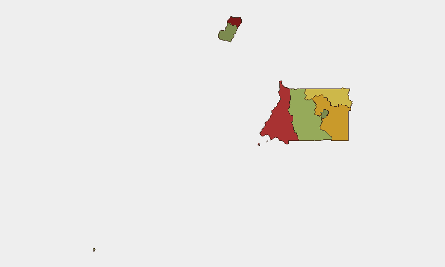
Bioko Norte (risk 85) and Litoral Province (risk 78) drive the country's subnational risk hierarchy, reflecting cross-border trafficking networks, maritime-crime pressure, and proximity to regional instability corridors. Wele-Nzas Province (risk 72) and Kié-Ntem Province (risk 68) face similar transnational-crime and border-management pressures; both regions experience sporadic smuggling and unofficial movement of persons and contraband. Centro Sur Province (risk 45) remains moderately elevated. Southern and island regions (Bioko Sur, Djibloho, Annobón) show significantly lower risk scores, reflecting smaller population, reduced criminal activity, and limited infrastructure targets. Risk is concentrated in the north and northwest, where state capacity and monitoring are lower and regional trafficking corridors are most active.
How GeoBit Would Assist
Security teams with personnel or assets in Equatorial Guinea should deploy AOI Monitoring & Early Warning on Malabo, Bata, and key oil-sector infrastructure zones to detect sudden protests, security-force movements, or diplomatic incidents before they escalate. Intel Sweep and X/Twitter OSINT with Spanish-language keywords and local influencer tracking will surface nascent unrest, labor disputes, or community tensions earlier than major outlets. Network & Actor Analysis focused on regime-stability indicators (arrests of officials, military movement, factional signaling) and consular/diplomatic-feed monitoring (U.S. Embassy, French mission, Spanish mission) will clarify the status of the unconfirmed France–Equatorial Guinea dispute and flag any sudden expulsions, visa restrictions, or embassy closures.
7-Day Outlook
No major catalyst for acute security deterioration is visible in the near term. Baseline authoritarian repression and transnational-crime pressures will persist. The unverified diplomatic dispute with France warrants continued monitoring; if confirmed and escalated, it could trigger visa complications, diplomatic withdrawal, or targeted asset restrictions affecting corporate operations. Routine vigilance on northern provinces and maritime zones remains standard risk management.
Highest-Risk Areas — Ranked
| # | State / Region | Risk |
|---|---|---|
| 1 | Bioko Norte | 85 |
| 2 | Litoral Province | 78 |
| 3 | Wele-Nzas Province | 72 |
| 4 | Kié-Ntem Province | 68 |
| 5 | Centro Sur Province | 45 |
| 6 | Bioko Sur | 38 |
| 7 | Djibloho | 15 |
| 8 | Annobón Province | 8 |
Sources
Previous Daily Briefs
A new Equatorial Guinea brief is written every day — each with its own risk map and downloadable CSV. Here's the last week; use the calendar to go further back.
📅 Browse every day by calendar →
Highlighted days have a brief. Tap a day for that day's map & analysis, or “csv” for that day's dataset ($5).
Atlas — our AI intelligence desk — emails them this snapshot personally. Nothing else, no list.