Situation Summary
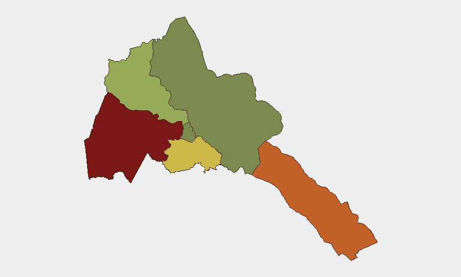
Eritrea remains a low-frequency threat environment globally (rank #164, composite score 5), with no discrete security incidents recorded in the current 24–48 hour window. The country's risk profile is heavily concentrated in its western and southern border regions, particularly Gash-Barka and the Southern Red Sea Region, where cross-border dynamics with Sudan and ongoing regional tensions create elevated but non-acute exposure. The capital region (Maekel) presents negligible risk. No protest activity, major arrests, infrastructure disruption, or armed incidents have been independently confirmed and time-stamped within the last two days.
Key Developments
No discrete, independently verified security incidents were recorded in Eritrea during the 24–48 hour window ending 5 July 2026. Open-web and social-media content reviewed does not contain clearly dated, multi-source corroborated events (armed clashes, protests, arrests, infrastructure damage) that can be reliably placed within this timeframe. Regional commentary on Eritrea–Sudan frontier dynamics and broader Horn of Africa security patterns exists, but lacks the temporal specificity and source corroboration required to treat as current operational events. Security teams should note that absence of reported incident does not indicate absence of risk; rather, it reflects Eritrea's limited open-source reporting density and the geopolitical insularity of the country's security apparatus.
Highest-Risk Areas
Gash-Barka (risk 92) and the Southern Red Sea Region (risk 75) dominate Eritrea's sub-national threat landscape, driven by cross-border instability involving Sudan, ungoverned transit corridors, and historical militia activity. Debub Region (risk 68) faces secondary exposure from similar transnational smuggling and armed-group transit patterns. These three zones account for the overwhelming majority of Eritrea's measurable security risk; by contrast, Maekel Region (the capital zone) presents negligible risk (18), and the Northern Red Sea Region registers zero tracked exposure. The disparity reflects Eritrea's geography: western and southern border areas remain porous and difficult to monitor, while the capital and northern coastal zones benefit from state capacity concentration and reduced cross-border friction.
How GeoBit Would Assist
Security teams with personnel or assets in Eritrea should employ AOI Monitoring & Early Warning on Gash-Barka and Southern Red Sea Region to detect emerging cross-border incidents, militia movement, or infrastructure disruption before they escalate. Intel Sweep and multi-language search capabilities enable continuous passive monitoring of Eritrean and regional media, social platforms, and humanitarian reporting to identify nascent unrest signals that open-source reporting may miss or delay. Network & Actor Analysis and GIS & Spatial Analysis support route-planning and checkpoint-risk assessment for personnel transit in high-risk zones, while entity extraction on regional radio SIGINT and Telegram networks can flag emerging smuggling or armed-group activity before mainstream reporting confirms it.
7-Day Outlook
No acute triggers are evident for the next week. Eritrea's baseline risk trajectory remains stable but sub-nationally differentiated: border regions will continue to experience low-level cross-border friction and contraband transit, while the capital and central zones will remain secure. Seasonal Red Sea weather and regional diplomatic activity (Eritrea–Djibouti, Eritrea–Ethiopia relations) should be monitored as secondary drivers of risk; however, no specific incidents or policy shifts are anticipated in the seven-day window.
Highest-Risk Areas — Ranked
| # | State / Region | Risk |
|---|---|---|
| 1 | Gash-Barka | 92 |
| 2 | Southern Red Sea Region | 75 |
| 3 | Debub Region | 68 |
| 4 | Anseba | 55 |
| 5 | Maekel Region | 18 |
| 6 | Northen Red Sea Region | 0 |
Sources
Previous Daily Briefs
A new Eritrea brief is written every day — each with its own risk map and downloadable CSV. Here's the last week; use the calendar to go further back.
📅 Browse every day by calendar →
Highlighted days have a brief. Tap a day for that day's map & analysis, or “csv” for that day's dataset ($5).
Atlas — our AI intelligence desk — emails them this snapshot personally. Nothing else, no list.