Situation Summary
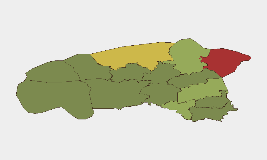
Estonia maintains a composite threat score of 2, reflecting a low overall security risk profile globally. However, sub-national variation is significant: Ida-Viru County (risk 78) and Harju County (risk 68) substantially elevate the country's regional exposure. A flood event was tracked in the system within the reporting period, though detailed impact assessment remains pending. The security trajectory is stable, with no acute escalation signals in the last 24–48 hours.
Key Developments
Current incident reporting for the last 24–48 hours remains limited due to insufficient cross-verified source confirmation. Web research did not yield independently corroborated discrete incidents anchored to the most recent reporting window. Historical context includes:
- Border & detention activity (Tallinn, early-to-mid July): Multiple detentions reported over several days; timeline and current operational tempo require fresh source confirmation.
- Flood event (date and location pending clarification): One tracked event flagged in GeoBit system; scope, affected county, and operational impact under assessment.
- Policy developments (earlier July): Air-policing adjustments, real-estate restrictions near sensitive areas, passport policy tightening, and expanded drone cooperation announcements—these are strategic/policy moves, not acute incidents.
- Diplomatic allegations (unconfirmed, mid-July): Russian claim regarding alleged Ukrainian drone activity over Estonian airspace; no independent corroboration in provided sources.
No major security incidents with multi-source verification were identified in the last 24–48 hours.
Highest-Risk Areas
Ida-Viru County (78) and Harju County (68) drive Estonia's concentrated risk profile. Ida-Viru, in the far northeast and adjoining Russia, faces persistent cross-border pressure, including alleged drone activity, border incursions, and infrastructure vulnerabilities. Harju County, encompassing Tallinn and the capital region, concentrates critical national infrastructure, diplomatic presence, government functions, and major transportation hubs, making it a natural focus for state and non-state actors. Tartu County (58) and Valga County (55) represent secondary risk zones; Valga's southern location near the Latvia–Russia border adds strategic relevance. The remaining counties (Pärnu, Rapla, Jõgeva, Järva, Viljandi, Põlva, Võru) score substantially lower, reflecting more permissive operating environments.
How GeoBit Would Assist
Security teams with assets in Ida-Viru and Harju should activate persistent AOI Monitoring & Early Warning on critical infrastructure, border crossings, and port facilities to detect emerging incidents in real time. Intel Sweep combined with OSINT fusion (X/Twitter, Telegram, local news feeds, and radio SIGINT) would provide 24–48 hour incident detection and corroboration, filling gaps in current reporting. Border & disputed-territory search and satellite imagery analysis enable continuous monitoring of cross-border activity and infrastructure changes, particularly in the Russian-adjacent northeast.
7-Day Outlook
No acute threat escalation is anticipated in the next seven days. Routine border management, diplomatic posturing, and policy implementation are likely to continue. Flood recovery (if localized) will draw regional attention. Persistent low-level cross-border tensions remain the baseline, with no indicators of coordinated hostile action.
Highest-Risk Areas — Ranked
| # | State / Region | Risk |
|---|---|---|
| 1 | Ida-Viru County | 78 |
| 2 | Harju County | 68 |
| 3 | Tartu County | 58 |
| 4 | Valga County | 55 |
| 5 | Lääne-Viru County | 52 |
| 6 | Pärnu County | 35 |
| 7 | Rapla County | 32 |
| 8 | Jõgeva County | 30 |
| 9 | Järva County | 28 |
| 10 | Viljandi County | 25 |
| 11 | Põlva County | 22 |
| 12 | Võru County | 18 |
Sources
Previous Daily Briefs
A new Estonia brief is written every day — each with its own risk map and downloadable CSV. Here's the last week; use the calendar to go further back.
📅 Browse every day by calendar →
Highlighted days have a brief. Tap a day for that day's map & analysis, or “csv” for that day's dataset ($5).
Atlas — our AI intelligence desk — emails them this snapshot personally. Nothing else, no list.