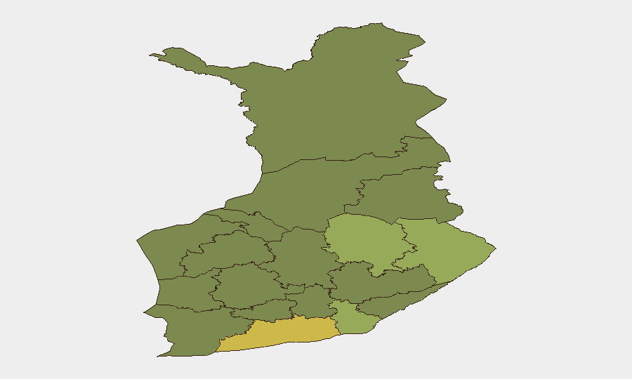
Situation Summary
Finland remains at low composite threat (rank #149 globally, score 6), with no tracked major incidents in the past 24–48 hours. However, recent drone incursions across the eastern Gulf of Finland and NATO Baltic airspace—including a shoot-down by allied fighters on 14 August and Finnish Defence Forces' precautionary traffic restrictions—signal heightened regional security posture linked to Ukraine spillover and ongoing NATO border tensions. A completed NBI terrorism-financing investigation into PKK supporters and routine back-to-school police enforcement represent manageable domestic security operations, but the sub-national risk profile shows pronounced concentration in the eastern and central regions.
Key Developments
- Eastern Gulf of Finland, 14 Aug 2026 – Finnish Defence Forces imposed temporary restrictions on aviation and maritime traffic (04:00–07:43) in response to a possible drone threat; NATO-linked allied fighters (Italian and Turkish aircraft) shot down a drone that had entered Latvian airspace the same day, underscoring ongoing spillover of Ukraine-related drone activity into the Baltic.
- National, 16 Aug 2026 – The National Bureau of Investigation completed a criminal investigation into four individuals suspected of supporting the EU-listed terrorist organisation PKK, including fundraising across multiple municipalities since November 2024; the case has been referred to the Office of the Prosecutor General for prosecution consideration.
- Kaivopuisto, Helsinki, 13 Aug 2026 – Police issued temporary unmanned aircraft system (UAS/drone) restrictions in the vicinity of the U.S. Embassy reception, reflecting targeted airspace security measures for high-profile diplomatic events.
- National, 10–21 Aug 2026 (ongoing) – Intensified police traffic enforcement campaign around schools nation-wide as classes resume, with elevated monitoring to prevent accidents; localized traffic delays possible in school zones.
- Helsinki Ring Rail Line, effective 10 Aug–4 Oct – Malminkartano station remains closed until 7 September; train frequencies on the western loop reduced to every 20–30 minutes until 4 October, affecting travel reliability and airport access in the region.
Highest-Risk Areas
Uusimaa (Helsinki metropolitan area; risk 65) dominates the national risk profile, driven by concentration of critical infrastructure, diplomatic presence, and transport hubs. The eastern border regions—North Karelia, Kymenlaakso, North Savo, and South Karelia (risks 44–38)—reflect proximity to Russian territory and ongoing drone/airspace incidents in the Gulf of Finland, amplified by NATO border vigilance and Ukraine-related spillover. Central and western regions (Kainuu, Päijät-Häme, Southwest Finland; risks 36–25) carry lower but sustained risk from scattered low-order incidents and routine law-enforcement activity. The sharp drop-off from Uusimaa suggests risk concentration rather than systemic national instability.
How GeoBit Would Assist
Security teams operating in Finland should leverage AOI Monitoring & Early Warning focused on the eastern Gulf of Finland and Uusimaa to detect drone incursions, traffic restrictions, or airspace anomalies in near-real time. Conflict & Military tracking (force posture, NATO readiness, cross-border activity) combined with multi-language OSINT and X/Twitter intelligence will capture Defence Forces announcements and regional defence developments before broad circulation. Routing & Network Analysis should incorporate current rail/airport disruptions to ensure contingency travel planning for personnel and supply chains transiting Helsinki.
7-Day Outlook
No major escalation expected; the drone incidents reflect regional pattern, not acute national crisis. Back-to-school enforcement and embassy-linked restrictions will persist through mid-to-late August. Watch for any NATO or Finnish Defence Forces statements on sustained airspace restrictions or Baltic drone trends, which could signal prolonged operational alertness or new incidents.
Highest-Risk Areas — Ranked
| # | State / Region | Risk |
|---|---|---|
| 1 | Uusimaa | 65 |
| 2 | North Karelia | 44 |
| 3 | Kymenlaakso | 42 |
| 4 | North Savo | 40 |
| 5 | South Karelia | 38 |
| 6 | Kainuu | 36 |
| 7 | Päijät-Häme | 35 |
| 8 | South Savo | 32 |
| 9 | Kanta-Häme | 30 |
| 10 | Pirkanmaa | 28 |
| 11 | Central Finland | 26 |
| 12 | Southwest Finland | 25 |
Sources
Previous Daily Briefs
A new Finland brief is written every day — each with its own risk map and downloadable CSV. Here's the last week; use the calendar to go further back.
- August 14, 2026
- August 12, 2026
- August 10, 2026
- August 8, 2026
- August 6, 2026
- August 5, 2026
- August 4, 2026
📅 Browse every day by calendar →
Highlighted days have a brief. Tap a day for that day's map & analysis, or “csv” for that day's dataset ($5).
Atlas — our AI intelligence desk — emails them this snapshot personally. Nothing else, no list.