Situation Summary
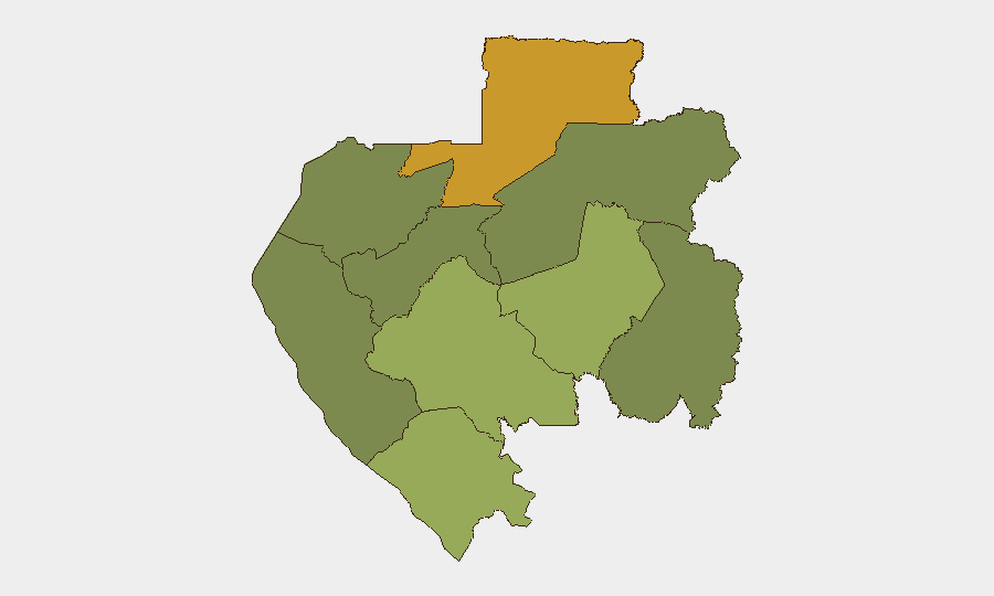
Gabon remains at low global security risk (rank #173, composite score 3), with no major incidents reported in the last 24–48 hours. Sub-national risk is concentrated in the northeastern and southeastern border regions, particularly Woleu-Ntem and Ogooué-Lolo provinces, where underlying vulnerabilities—including porous borders, limited state presence, and regional instability—persist. The capital Libreville and western coastal zones remain relatively stable. Current threat trajectory is stable, contingent on maintenance of border security and absence of significant political or economic shocks.
Key Developments
No specific, corroborated security incidents, civil unrest, infrastructure failures, or conflict events in Gabon were identified in open-source reporting from 22–23 June 2026. Two low-specificity signals tagged "Disapprove" (attributed to citizen sentiment and a Gambia reference) on 23 June lack geographic, temporal, or event detail and do not indicate actionable incidents. Operational security teams are advised to monitor live local media, embassy alerts, and regional wire services for any emerging developments not yet reflected in global feeds.
Highest-Risk Areas
Woleu-Ntem Province (risk 72) in the northeast—bordering Cameroon and Equatorial Guinea—carries the highest sub-national risk, reflecting cross-border trafficking, limited law enforcement capacity, and spillover from regional instability. Ogooué-Lolo Province (risk 58) in the southeast, bordering the Republic of the Congo, presents similar vulnerabilities. Together, these provinces account for most of Gabon's residual risk. Central and western provinces, including Estuaire (Libreville) and Ogooué-Ivindo, show minimal risk. The disparity reflects Gabon's uneven state capacity and geography: remote, forested interior regions with weak administrative presence and porous borders are higher-risk; urban centers and the developed coast are lower-risk.
How GeoBit Would Assist
For ongoing Gabon duty-of-care operations, security teams would deploy AOI Monitoring & Early Warning on Woleu-Ntem and Ogooué-Lolo provinces to detect emerging unrest, cross-border activity, or infrastructure incidents with persistent alerting. Multi-language OSINT (Intel Sweep, X/Twitter, local media search) would provide real-time tracking of political sentiment, protest activity, and official advisories, filtered by province and event type. GIS & Spatial Analysis would support route planning and risk-based site assessments for personnel or asset movements, especially in the northeast. Network & Actor Analysis would map local power brokers, criminal networks, and armed groups active in high-risk zones.
7-Day Outlook
No imminent escalation is forecast. Barring unexpected political instability or a significant cross-border incident in the northeast, Gabon's security posture is expected to remain stable over the next seven days. Monitoring should focus on border regions and any unusual official or civil-society activity; mid-year economic or political announcements could shift risk dynamics.
Note: This brief reflects the limits of current open-source access. Security teams operating in or transiting Gabon should supplement this assessment with real-time embassy alerts, local intelligence, and direct liaison with in-country partners.
Highest-Risk Areas — Ranked
| # | State / Region | Risk |
|---|---|---|
| 1 | Woleu-Ntem | 72 |
| 2 | Ogooué-Lolo Province | 58 |
| 3 | Ngounié Province | 48 |
| 4 | Nyanga Province | 42 |
| 5 | Haut-Ogooué Province | 35 |
| 6 | Moyen-Ogooué Province | 28 |
| 7 | Ogooué-Maritime Province | 25 |
| 8 | Estuaire Province | 15 |
| 9 | Ogooué-Ivindo | 0 |
Sources
Previous Daily Briefs
A new Gabon brief is written every day — each with its own risk map and downloadable CSV. Here's the last week; use the calendar to go further back.
📅 Browse every day by calendar →
Highlighted days have a brief. Tap a day for that day's map & analysis, or “csv” for that day's dataset ($5).