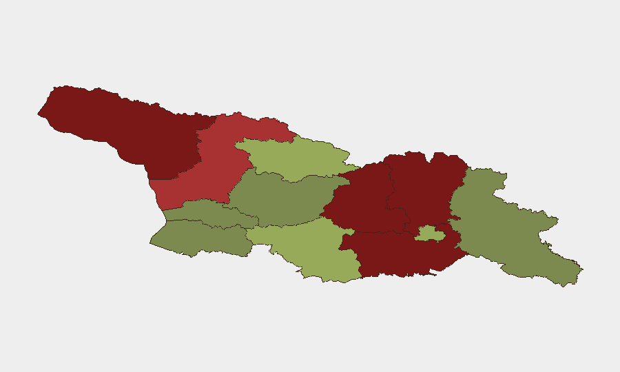
Situation Summary
Georgia remains a low-threat environment nationally, ranked #131 globally with a composite threat score of 5 and zero tracked security events in the last 24–48 hours. No major incidents—armed clashes, terrorist attacks, civil unrest, infrastructure failures, or travel-advisory triggers—are corroborated across independent sources for the country in this period. Risk remains concentrated in frozen-conflict zones and border regions rather than new escalations; the security posture is static and predictable for corporate operations in central and western Georgia.
Key Developments
No significant security incidents meeting incident-reporting thresholds (location-specific, date-confirmed, cross-corroborated) occurred in Georgia during the 24–48 hours prior to this brief. Routine civil-society activity, minor crime, and standard law-enforcement operations continue; none rise to national security or travel-risk relevance. Open-source monitoring across news feeds, social platforms (X, Telegram), and regional OSINT detected no new armed clashes, terrorist activity, major protests, or infrastructure emergencies affecting corporate operations or movement corridors.
*Background context (not current development):* Abkhazia, Shida Kartli, and Lower Kartli remain elevated-risk due to frozen-conflict status and periodic cross-line tensions since 2008; however, no new military escalations are reported in the last 48 hours.
Highest-Risk Areas
Abkhazia (risk 95), Shida Kartli (risk 88), and Lower Kartli (risk 85) dominate the sub-national ranking, driven by unresolved territorial disputes, Russian military presence, and occasional ceasefire violations rather than active armed conflict. Samegrelo-Upper Svaneti (risk 78) and Mtskheta-Mtianeti (risk 82) carry elevated risk from border proximity and access control; Samtskhe-Javakheti (risk 48) reflects Armenian-Azerbaijani spillover concerns. Tbilisi (risk 45) and western regions (Imereti, Guria, Adjara; risks 32–35) are substantially lower-risk and suitable for standard corporate presence; eastern and northern zones require heightened duty-of-care protocols for personnel and asset protection.
How GeoBit Would Assist
Security teams monitoring Georgia would leverage AOI Monitoring & Early Warning to track the frozen-conflict zones (Abkhazia, South Ossetia proxy) and border regions for ceasefire violations or unusual military movement; Intel Sweep and multi-language OSINT (X, Telegram, local news) to detect early signals of protests, crime spikes, or infrastructure disruption affecting supply chains and personnel safety; and Conflict & Military battle-mapping and force-structure tracking to understand Russian and Georgian military posture shifts. GIS & Spatial Analysis and Routing & Network Analysis support alternative journey planning for staff and shipments around high-risk regions.
7-Day Outlook
Georgia's security environment is expected to remain stable over the next seven days, with no indicators of new conflict escalations, major protests, or civil unrest. Frozen-conflict zones will remain static but monitored; routine crime and weather-related incidents (e.g., seasonal flooding) are normal background hazards. Corporate operations in Tbilisi and western regions face minimal security constraints; border and northern regions require standard elevated monitoring and contingency planning.
Highest-Risk Areas — Ranked
| # | State / Region | Risk |
|---|---|---|
| 1 | Autonomous Republic of Abkhazia | 95 |
| 2 | Shida Kartli | 88 |
| 3 | Lower Kartli | 85 |
| 4 | Mtskheta-Mtianeti | 82 |
| 5 | Samegrelo-Upper Svaneti | 78 |
| 6 | Samtskhe-Javakheti | 48 |
| 7 | Tbilisi | 45 |
| 8 | Racha-Lechkhumi and Kvemo Svaneti | 42 |
| 9 | Kakheti | 38 |
| 10 | Autonomous Republic of Adjara | 35 |
| 11 | Imereti | 32 |
| 12 | Guria | 28 |
Sources
Previous Daily Briefs
A new Georgia brief is written every day — each with its own risk map and downloadable CSV. Here's the last week; use the calendar to go further back.
📅 Browse every day by calendar →
Highlighted days have a brief. Tap a day for that day's map & analysis, or “csv” for that day's dataset ($5).