Situation Summary
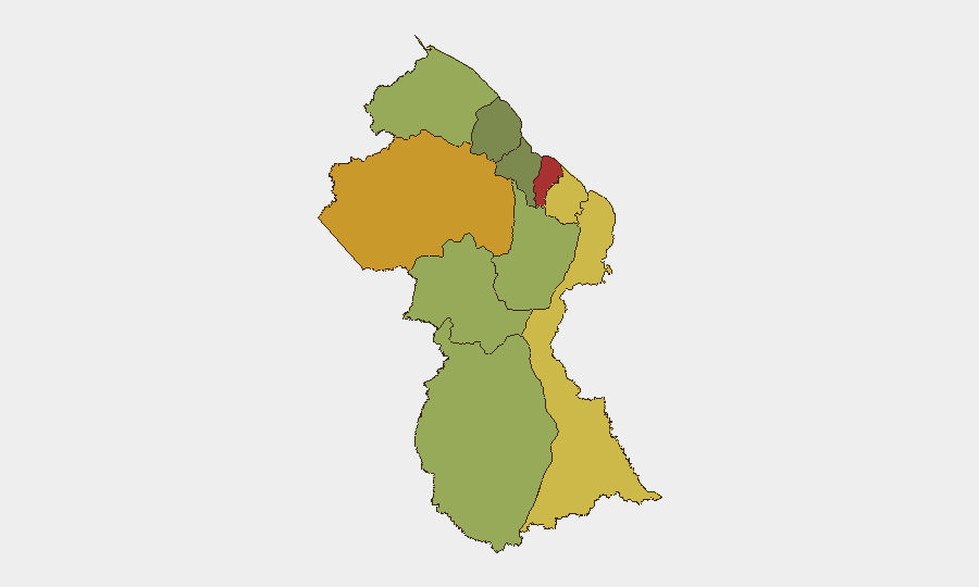
Guyana is experiencing acute maritime and border security stress following the MV Barima ferry disaster (18–24 July), which has claimed at least 57 confirmed deaths and left 4–6 people missing; concurrent with ongoing search operations, the Guyana Defence Force reported three armed cross-border incidents from Venezuelan territory within the past 24 hours, signalling elevated tension along the Cuyuni River frontier. Criminal investigations into the ferry capsizing and political friction around victim documentation have added domestic instability. The national threat composite remains moderate (rank #75 globally, score 14), but sub-national risk is sharply concentrated in coastal and border regions, with Demerara-Mahaica (78) and Cuyuni-Mazaruni (72) as primary concern zones.
Key Developments
- Cuyuni River, Guyana–Venezuela Border – 24 July 2026 (within past 24h)
GDF reported three armed attacks from Venezuelan civilian-clothed assailants against Guyanese soldiers along the Cuyuni River in a single 24-hour period; no Guyanese casualties reported, "measured responses" executed. This represents the most acute cross-border security incident in recent briefing cycle and signals heightened frontier volatility.
- Off Essequibo Coast – 23–24 July 2026 (ongoing operations)
Search and recovery operations for MV Barima wreck continue across ~2,100 km² with 16+ vessels and dive teams deployed; 57 bodies confirmed recovered, 4–6 missing, 76 rescued; authorities confirm no additional survivors in submerged vessel and have launched criminal investigation into overloading, manifest fraud, and crew conduct.
- Georgetown, National Level – 23–24 July 2026
Government announced formal criminal probe into MV Barima capsizing with focus on safety compliance and cargo irregularities; three-day national mourning declared; systematic pre-departure vessel inspections mandated nationwide.
- Charity, Pomeroon–Supenaam (Region 2) – 23 July 2026
Opposition MP Sherod Duncan detained by police while documenting ferry disaster aftermath and visiting victim families; drone, camera, and equipment seized by officers at disaster site, indicating political sensitivity around media/documentation of the incident.
- Georgetown, National Security Policy – 23–24 July 2026
President Ali reiterated commitment to technology-driven national security infrastructure (smart police stations, AI crime prediction, nationwide CCTV by 2030); policy-level announcement but reflects medium-term security posture.
Highest-Risk Areas
Demerara-Mahaica (78) and Cuyuni-Mazaruni (72) dominate the sub-national ranking and drive overall national risk assessment. Demerara-Mahaica encompasses the capital and coastal ferry routes where the MV Barima disaster unfolded, maritime transit infrastructure, and dense urban populations; Cuyuni-Mazaruni's elevation reflects the active Venezuela border tension, remote interior geography, and resource-extraction activity. Mahaica-Berbice (65) and East Berbice-Corentyne (62) remain secondary concern zones with ongoing maritime and riverine exposure. Western interior regions and the Essequibo Islands show comparatively lower scores but remain subject to border volatility and limited state presence.
How GeoBit Would Assist
Teams with personnel or assets in Guyana should deploy AOI Monitoring & Early Warning on Cuyuni River and maritime approaches to flag cross-border or vessel-safety incidents in near-real-time. Maritime & Aviation tracking combined with multi-language OSINT and Telegram/X feeds enables continuous watch on ferry schedules, crew background checks, and emerging maritime incidents. GIS & Spatial Analysis and Routing & Network Analysis support alternative travel planning around high-risk coastal and border corridors.
7-Day Outlook
Recovery operations and criminal investigation into MV Barima will continue through early August; political pressure on government accountability is likely to intensify. Venezuelan border incidents may recur if tensions remain unresolved; monitor GDF statements and regional diplomatic channels. Domestic security operations will increase vessel inspections, potentially affecting maritime transport schedules.
Highest-Risk Areas — Ranked
| # | State / Region | Risk |
|---|---|---|
| 1 | Demerara-Mahaica | 78 |
| 2 | Cuyuni-Mazaruni | 72 |
| 3 | Mahaica-Berbice | 65 |
| 4 | East Berbice-Corentyne | 62 |
| 5 | Upper Demerara-Berbice | 58 |
| 6 | Potaro-Siparuni | 48 |
| 7 | Barima-Waini | 45 |
| 8 | Upper Takutu-Upper Essequibo | 42 |
| 9 | Pomeroon-Supenaam | 38 |
| 10 | Essequibo Islands | 35 |
Sources
Previous Daily Briefs
A new Guyana brief is written every day — each with its own risk map and downloadable CSV. Here's the last week; use the calendar to go further back.
📅 Browse every day by calendar →
Highlighted days have a brief. Tap a day for that day's map & analysis, or “csv” for that day's dataset ($5).
Atlas — our AI intelligence desk — emails them this snapshot personally. Nothing else, no list.