Situation Summary
Guyana remains a low-threat environment globally (composite threat score 13) with minimal tracked security incidents. However, concentration of risk is heavily skewed toward Demerara-Mahaica region (score 31.3), which accounts for the majority of the nation's security burden. Two tracked events from 2026-07-26 and 2026-07-28 (Armed Forces and Representatives public statements) suggest routine governance activity rather than acute security deterioration. The overall trajectory is stable, though the geographic concentration warrants focused monitoring of the capital region.
Key Developments
Unable to confirm specific incident-level developments from the last 24–48 hours with sufficient confidence. GeoBit's current event signals reference public statements from Armed Forces (2026-07-26) and Representatives (2026-07-28), but source material does not provide actionable detail on statement content or implications. Historical context: MV Barima ferry capsized off Iron Punt (2026-07-21 to 2026-07-23), resulting in fatalities and large-scale search-and-rescue operations, but this falls outside the 48-hour reporting window. Corporate teams requiring operational awareness of July 27–28 developments should supplement this brief with live web and official Guyana government channels to confirm any emerging incidents.
Highest-Risk Areas
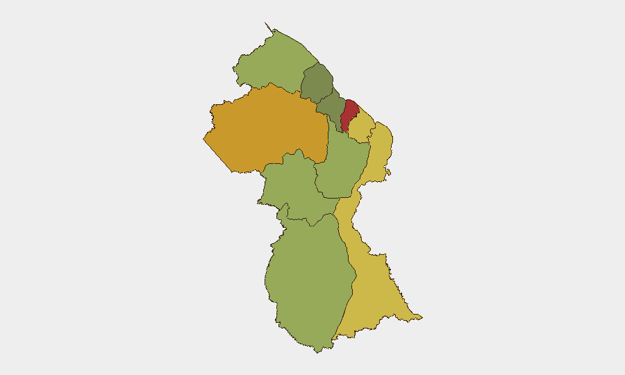
Demerara-Mahaica dominates the sub-national risk ranking with a score of 31.3—approximately 24 times higher than any other region—indicating that Georgetown and its metropolitan corridor concentrate the vast majority of Guyana's security burden. All other nine regions (Barima-Waini, Cuyuni-Mazaruni, East Berbice-Corentyne, and others) register uniformly at 1.3, suggesting either minimal incident activity or sparse monitoring coverage in interior and peripheral zones. This disparity reflects predictable geographic concentration in the capital: higher population density, commercial activity, administrative functions, and accompanying crime/civil-unrest risk. Teams with assets or personnel outside the capital may face *lower* acute threat but should account for isolation, limited emergency services, and border-zone dynamics in remote regions.
How GeoBit Would Assist
Area-of-Interest (AOI) Monitoring & Early Warning on Demerara-Mahaica (Georgetown–East Bank corridor) with persistent alerting would provide corporate teams 24/7 notification of emerging incidents, protests, or security operations before they impact operations. Multi-language OSINT fusion (X/Twitter, Telegram, local news, police radio) across Guyana's public channels would surface incident details, official statements, and civil-unrest signals faster than traditional corporate reporting. Route & Network Analysis and alternative journey planning capabilities would allow security teams to identify safe transit corridors and contingency logistics if primary routes (e.g., coastal road, ferry routes) are disrupted by incident or civil disturbance.
7-Day Outlook
No acute escalation indicators are visible over the next 7 days; governance statements and low overall threat score suggest routine operations. However, the geometric concentration of risk in Demerara-Mahaica means that any incident (crime surge, protest, labor action, or border tension) will disproportionately affect capital-region operations. Teams should maintain standard due-care monitoring and prepare contingency protocols for brief localized disruption; major national security deterioration is not indicated.
Highest-Risk Areas — Ranked
| # | State / Region | Risk |
|---|---|---|
| 1 | Demerara-Mahaica | 31.3 |
| 2 | Barima-Waini | 1.3 |
| 3 | Cuyuni-Mazaruni | 1.3 |
| 4 | Pomeroon-Supenaam | 1.3 |
| 5 | Essequibo Islands | 1.3 |
| 6 | Mahaica-Berbice | 1.3 |
| 7 | Potaro-Siparuni | 1.3 |
| 8 | Upper Demerara-Berbice | 1.3 |
| 9 | East Berbice-Corentyne | 1.3 |
| 10 | Upper Takutu-Upper Essequibo | 1.3 |
Sources
Previous Daily Briefs
A new Guyana brief is written every day — each with its own risk map and downloadable CSV. Here's the last week; use the calendar to go further back.
📅 Browse every day by calendar →
Highlighted days have a brief. Tap a day for that day's map & analysis, or “csv” for that day's dataset ($5).
Atlas — our AI intelligence desk — emails them this snapshot personally. Nothing else, no list.