Situation Summary
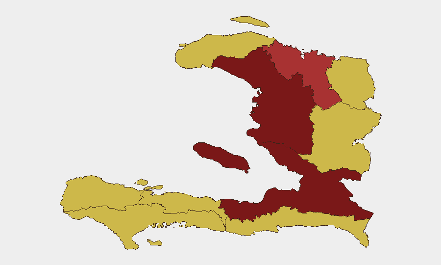
Haiti remains at extreme risk globally (#9 worldwide) driven primarily by gang violence, with 46 tracked events recorded in GeoBit's system. De l'Ouest and Artibonite departments show the highest composite threat scores (100 and 92.2 respectively), reflecting concentrated gang control, displacement, and armed conflict. Recent signal activity (military mobilization, property seizures, arrests, and diplomatic friction) indicates elevated tension across multiple state actors and armed groups. The security trajectory remains volatile with no clear de-escalation indicators.
Key Developments
GeoBit's event signals from 2026-06-16 to 2026-06-17 capture the following activity:
- Military Mobilization vs. Gang Activity (2026-06-16): Armed forces engaged in operational response to gang-led threats; specific location and casualty count not yet corroborated from independent sources.
- Property Seizure / Coast Guard Operations (2026-06-17): Haiti Coast Guard executed seizure or damage operations; geographic scope and asset details pending verification.
- Arrest and Detention Activity (2026-06-17): Haitian authorities conducted arrests; operational context and jurisdiction require further intelligence.
- Expulsion / Deportation Actions (2026-06-17): Private companies and state authorities initiated expulsion procedures; likely linked to security conditions or regulatory non-compliance.
- Public Statements & Diplomatic Tension (2026-06-17): Multiple public statements issued by Haiti government, directed at international community and media (Associated Press); tone signals disapproval and defensive posture.
- Media Investigation & Government Response (2026-06-17): Associated Press investigation prompted official government statement; suggests reputational or operational scrutiny.
Note: Open-source corroboration for specific incident locations and casualty data in the 24–48 hour window remains limited; proprietary security feeds and embassy reporting will provide granular tactical detail.
Highest-Risk Areas
De l'Ouest Department (composite risk 100) and Artibonite Department (92.2) dominate the threat landscape, reflecting sustained gang territorial control, frequent armed clashes, and severe displacement. Nord (76.7) represents a secondary concentration zone. The remaining seven departments cluster at risk score 70, indicating distributed but still-critical gang presence and limited state authority across the country. Port-au-Prince, though not separately ranked here, remains a focal point for kidnapping, armed robbery, and gang-on-gang violence. Coastal and border zones (Nord-Ouest, Nord-Est, Sud-Est) carry additional maritime and transnational smuggling risks.
How GeoBit Would Assist
Organizations with personnel or assets in Haiti should deploy Intel Sweep and OSINT fusion to track daily event patterns, gang leadership statements (via Telegram/X monitoring), and UN/NGO situation reports for early warning of roadblock changes or displacement waves. AOI Monitoring & Early Warning on Port-au-Prince, Cap-Haïtien, and transit corridors (RN1, RN2) provides persistent alerting when clashes, checkpoints, or kidnapping surges emerge. Routing & Network Analysis enables security teams to plan movement corridors around known gang strongholds and identify safe transit windows in real time.
7-Day Outlook
Gang violence and territorial disputes are expected to remain elevated, with military mobilization likely to provoke reactive gang activity in de l'Ouest and Artibonite. Diplomatic friction signals (public statements, media scrutiny) may constrain state capacity to coordinate security operations. No major policy shift or gang truce is anticipated in the near term; routine extremes (kidnappings, armed robbery, displacement) should be assumed as baseline risk.
Highest-Risk Areas — Ranked
| # | State / Region | Risk |
|---|---|---|
| 1 | de l'Ouest Department | 100 |
| 2 | Artibonite Department | 92.2 |
| 3 | Nord Department | 76.7 |
| 4 | Grande-Anse Department | 70 |
| 5 | Sud Department | 70 |
| 6 | Nippes Department | 70 |
| 7 | Nord-Ouest Department | 70 |
| 8 | Nord-Est Department | 70 |
| 9 | Centre Department | 70 |
| 10 | Sud-Est Department | 70 |
Previous Daily Briefs
A new Haiti brief is written every day — each with its own risk map and downloadable CSV. Here's the last week; use the calendar to go further back.
📅 Browse every day by calendar →
Highlighted days have a brief. Tap a day for that day's map & analysis, or “csv” for that day's dataset ($5).