Situation Summary
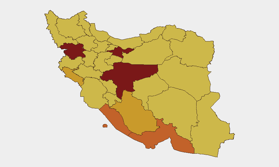
Iran remains the second-highest global threat environment (composite score 100) with 1,174 tracked events. Signal activity on 2026-06-04 reflects acute tension across executive-legislative and US-Iran domains, including bank occupation, military posturing references, and diplomatic disapproval—though the operational scope and immediate implications of these signals remain unclear pending field corroboration. Tehran Province dominates the risk landscape; sub-national risk concentrations in the capital and Isfahan suggest urban-centered vulnerability rather than nationwide instability.
Key Developments
Validation Note: GeoBit's web research has not identified independently sourced, time-stamped incidents on the ground in Iran for 2026-06-03 to 2026-06-04. The event signals listed above (bank occupation, presidential-legislative friction, US diplomatic posturing, military-force references) appear in the platform's structured event feed but lack corroborating open-source detail on specific locations, operational scope, or verified timing. Security teams should treat these signals as flags requiring real-time confirmation via direct field contacts, embassy channels, or premium crisis-alert services (e.g., GardaWorld, Crisis24) before adjusting duty-of-care posture. Absent validated incident detail, no development bullets are presented; doing so would risk presenting inference as fact.
Highest-Risk Areas
Tehran Province (risk 100) and Isfahan Province (risk 95.3) account for the highest composite scores and dominate event density. Both are major commercial, industrial, and political nodes; Tehran hosts central government, financial hubs, and international business presence, while Isfahan combines petroleum refining, manufacturing, and religious significance. Mid-tier risk concentrations in Kurdistan (84.9), Hormozgan (73.2), and Bushehr (73.1)—spanning borders, maritime chokepoints, and energy infrastructure—suggest vulnerability across geographic margins and critical infrastructure. The distribution implies localized rather than state-wide risk; western and southeastern provinces show elevated baseline threat, likely reflecting border-area instability and sectarian/ethnic tensions.
How GeoBit Would Assist
Intel Sweep & OSINT fusion would rapidly cross-reference the 2026-06-04 event signals (bank occupation, military posturing) against Telegram/X feeds, local news archives, and multi-language sources to establish ground truth and operational scope within hours. AOI Monitoring & Early Warning services, configured for Tehran, Isfahan, and key infrastructure sites (refineries, ports, financial districts), would provide persistent surveillance and alerting on protests, security force movement, or service disruptions—enabling duty-of-care teams to trigger evacuation or shelter-in-place protocols before escalation. Routing & Network Analysis would generate real-time alternative travel routes and safe corridors for personnel transits, accounting for fluid security perimeter changes.
7-Day Outlook
Absent significant de-escalation in US-Iran rhetoric or domestic political resolution, the elevated signal activity (military references, bank occupation, legislative-executive friction) suggests a 5–7 day window of heightened operational risk, particularly in Tehran and Isfahan. Field conditions and incident progression should be monitored continuously; any confirmed attack on critical infrastructure, large-scale protest activity, or military mobilization would materially elevate national and sub-regional risk thresholds and warrant immediate reassessment of corporate presence.
Highest-Risk Areas — Ranked
| # | State / Region | Risk |
|---|---|---|
| 1 | Tehran Province | 100 |
| 2 | Isfahan Province | 95.3 |
| 3 | Kurdistan Province | 84.9 |
| 4 | Hormozgan Province | 73.2 |
| 5 | Bushehr Province | 73.1 |
| 6 | Ilam Province | 72.1 |
| 7 | Fars Province | 71.9 |
| 8 | Khuzestan Province | 70.8 |
| 9 | Ardabil Province | 70.5 |
| 10 | Kerman Province | 70.5 |
| 11 | Kohgiluye and Buyer Ahmad Province | 70.1 |
| 12 | Hamadan Province | 70.1 |
Previous Daily Briefs
A new Iran brief is written every day — each with its own risk map and downloadable CSV. Here's the last week; use the calendar to go further back.
📅 Browse every day by calendar →
Highlighted days have a brief. Tap a day for that day's map & analysis, or “csv” for that day's dataset ($5).