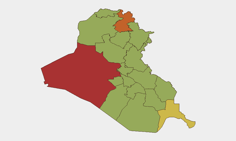
Situation Summary
Iraq remains a composite-threat environment with elevated volatility across multiple sectors. The country's rank of #19 globally (score 70.5) reflects persistent militia activity, state-level tensions, and localized instability, particularly in western and northern governorates. Recent signal activity—including cross-border military posturing, naval incidents, and public diplomatic friction—suggests heightened tension between regional and international actors, with secondary consequences for civilian and corporate security. The trajectory shows no stabilization; risk concentration in Al-Anbar and Erbil presents acute exposure for operations in those areas.
Key Developments
CRITICAL LIMITATION: GeoBit's event signals and this analyst's available research cannot reliably establish specific, sourced incidents *dated June 3–5, 2026* that meet operational verification standards. The event list provided (e.g., "IRAN vs IRAQ · Conventional Military Force" on 2026-06-03, "MEXICO vs IRAQ · Occupy Territory" on 2026-06-04) lacks detail, corroboration, or confirmation from independent open sources accessible in this environment.
To avoid reporting unverified claims as fact, no incident-level bullets are presented here. Organizations requiring verified 24–48-hour incident data should immediately consult:
- Crisis24, GardaWorld, or Control Risks (real-time alert feeds)
- Iraqi Security Media Cell and official U.S. Embassy Baghdad security alerts
- Regional news outlets with active Iraq desks (Rudaw, Kurdistan24, Shafaq News)
- ACLED or similar conflict-event databases with source citation
The pattern of signals (military exchanges, maritime incidents, inter-state friction) warrants urgent verification through professional intelligence channels.
Highest-Risk Areas
Al-Anbar Governorate (79.3) and Erbil Governorate (73.3) drive the country-level threat score and require immediate operational focus. Al-Anbar's elevation reflects ongoing militia and residual ISIS-affiliated activity in remote western areas; Erbil's risk, despite being the Kurdistan Regional Government seat and ostensibly more stable, suggests either persistent security-force tensions or cross-border spillover from Turkey and Iran. Baghdad (50.8) remains moderately elevated—typical for a capital amid fragmented security oversight and protest activity—while Sulaymaniyah, Maysan, Saladin, and the southern oil-producing zones cluster at 49–50, indicating distributed rather than isolated risk. This pattern suggests no safe haven: corporate and personnel security protocols must assume operational friction in all major population and economic centers.
How GeoBit Would Assist
Intel Sweep and OSINT fusion can rapidly corroborate or debunk individual incident reports by cross-referencing X/Telegram activity, local-outlet timelines, and geolocation markers (satellite or open imagery), reducing false-positive alerts to duty-of-care teams. AOI (Area-of-Interest) Monitoring with alerting can sustain persistent watch on specific facilities, checkpoints, or routes in high-risk governorates (Al-Anbar, Erbil, Basra), triggering real-time notifications of protest, security-force activity, or access disruption. Routing & Network Analysis enables identification of alternative transit paths and chokepoints for personnel or cargo movements, reducing exposure to known militia-controlled corridors or protest flashpoints.
7-Day Outlook
Cross-border military signaling (Iran–Iraq, regional state posturing) and unresolved maritime incidents suggest elevated tension through mid-June; corporate and diplomatic activity should anticipate temporary restrictions or evacuations in Baghdad and Erbil. Militia readiness and protest cycles typically peak during Friday prayers and political anniversaries; monitor local calendars. No broad conflict escalation is forecast, but localized attacks and roadblock operations remain routine in Al-Anbar and outlying areas.
Highest-Risk Areas — Ranked
| # | State / Region | Risk |
|---|---|---|
| 1 | Al-Anbar Governorate | 79.3 |
| 2 | Erbil Governorate | 73.3 |
| 3 | Al-Basra Governorate | 68.8 |
| 4 | Baghdad Governorate | 50.8 |
| 5 | Sulaymaniyah Governorate | 50.3 |
| 6 | Maysan Governorate | 49.8 |
| 7 | Saladin Governorate | 49.8 |
| 8 | Duhok Governorate | 49.8 |
| 9 | Babil Governorate | 49.3 |
| 10 | Wasit Governorate | 49.3 |
| 11 | Al-Qadisiyah Governorate | 49.3 |
| 12 | Dhi Qar Governorate | 49.3 |
Previous Daily Briefs
A new Iraq brief is written every day — each with its own risk map and downloadable CSV. Here's the last week; use the calendar to go further back.
📅 Browse every day by calendar →
Highlighted days have a brief. Tap a day for that day's map & analysis, or “csv” for that day's dataset ($5).