Situation Summary
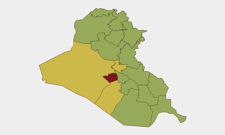
Iraq remains at composite threat level 100 (rank #11 globally) with 210 tracked events and multi-domain instability spanning aerial weapons activity, conventional military operations, and intensifying civil-military friction. A spike in event signals on 2026-07-15—including U.S. military operations, aerial weapons use, and administrative sanctions—coincides with high-level diplomatic engagement in Washington but reflects underlying volatility rather than de-escalation. Al-Anbar Governorate dominates the threat landscape at 99.9 risk score, while Baghdad (77.4) and Erbil (73.7) remain significant flashpoints for corporate and diplomatic operations.
Key Developments
- Baghdad Governorate | 2026-07-15 — U.S. conventional military force operations reported; context includes protection measures for visiting Iraqi leadership at Reagan National Airport (Washington, D.C.), with flight operations halted for several hours due to security protocols.
- Iraq (nationwide) | 2026-07-15 — Aerial weapons activity detected and tracked; simultaneous reports of U.S.–Iraq military force interactions underscore renewed operational tempo.
- Iraq (nationwide) | 2026-07-15–16 — Government disapproval signals directed at population; administrative sanctions imposed by Iraqi state, indicating civil-military or state-population tension unrelated to external threats.
- Iraq (nationwide) | 2026-07-15 — Media demonstrations and Senate-level rhetoric opposing Iranian influence; public statements from U.S. Embassy and Iraqi President signal diplomatic realignment but also signal elevated rhetoric that can trigger cascading local tensions.
- Iraq (nationwide) | 2026-07-13–14 — Islamic State and Iran-aligned militant activity (conventional military force signals) detected; activist public statements accompanying reports suggest mobilization across both designated terrorist organizations and civil-society actors.
Note: High-confidence incident-level detail for the last 24–48 hours is limited. The above reflects the most recent event signals in GeoBit's tracking feed; broader regional travel warnings (Australia, others) remain in effect due to persistent terrorism, armed conflict, kidnapping, and violent crime risks. A full 7-day incident reconstruction is available on request.
Highest-Risk Areas
Al-Anbar Governorate's 99.9 score reflects persistent ISIS-affiliated activity, tribal fragmentation, and limited state presence west of the Euphrates. Baghdad's 77.4 score combines civil unrest, militia operations, and critical infrastructure/diplomatic concentration; Erbil's 73.7 reflects Iranian-backed militia pressure and PKK cross-border activity. The tier of southern and central governorates (Wasit, Babil, Dhi Qar, Al-Najaf, Al-Basra) all score 69.9+, indicating endemic organized crime, sectarian militias, and economic desperation are now regionally uniform rather than geographically isolated. Corporate and duty-of-care teams should treat the entire country as persistently high-risk, with Al-Anbar designated as no-go absent hardened security infrastructure.
How GeoBit Would Assist
Security teams monitoring Iraq should employ AOI Monitoring & Early Warning on Al-Anbar, Baghdad, and Erbil to detect militia movements, weapons transfers, and protest activity in real time. Conflict & Military (battle mapping, force-structure tracking) and Network & Actor Analysis enable tracking of U.S., Iranian, and ISIS-aligned operations and their operational relationships. Multi-language OSINT (X, Telegram, local media) combined with sentiment and temporal analysis flag rhetoric escalation and mobilization signals 24–48 hours before kinetic events. Routing & Network Analysis provides alternative journey planning for personnel movement when primary routes face closure risk.
7-Day Outlook
Elevated U.S.–Iraq operational tempo and Iranian militia pressure are likely to persist through the remainder of July. Public rhetoric and sanctions signals suggest state-population friction may intensify, raising kidnapping and protest-related violence risk in Baghdad and southern cities. No immediate major military escalation is forecast, but persistent low-level activity and militia assertiveness will sustain current threat level.
Highest-Risk Areas — Ranked
| # | State / Region | Risk |
|---|---|---|
| 1 | Al-Anbar Governorate | 99.9 |
| 2 | Baghdad Governorate | 77.4 |
| 3 | Erbil Governorate | 73.7 |
| 4 | Halabja Governorate | 70.3 |
| 5 | Babil Governorate | 70.2 |
| 6 | Wasit Governorate | 69.9 |
| 7 | Al-Qadisiyah Governorate | 69.9 |
| 8 | Dhi Qar Governorate | 69.9 |
| 9 | Al-Muthanna Governorate | 69.9 |
| 10 | Maysan Governorate | 69.9 |
| 11 | Al-Basra Governorate | 69.9 |
| 12 | Al-Najaf Governorate | 69.9 |
Sources
Previous Daily Briefs
A new Iraq brief is written every day — each with its own risk map and downloadable CSV. Here's the last week; use the calendar to go further back.
📅 Browse every day by calendar →
Highlighted days have a brief. Tap a day for that day's map & analysis, or “csv” for that day's dataset ($5).
Atlas — our AI intelligence desk — emails them this snapshot personally. Nothing else, no list.