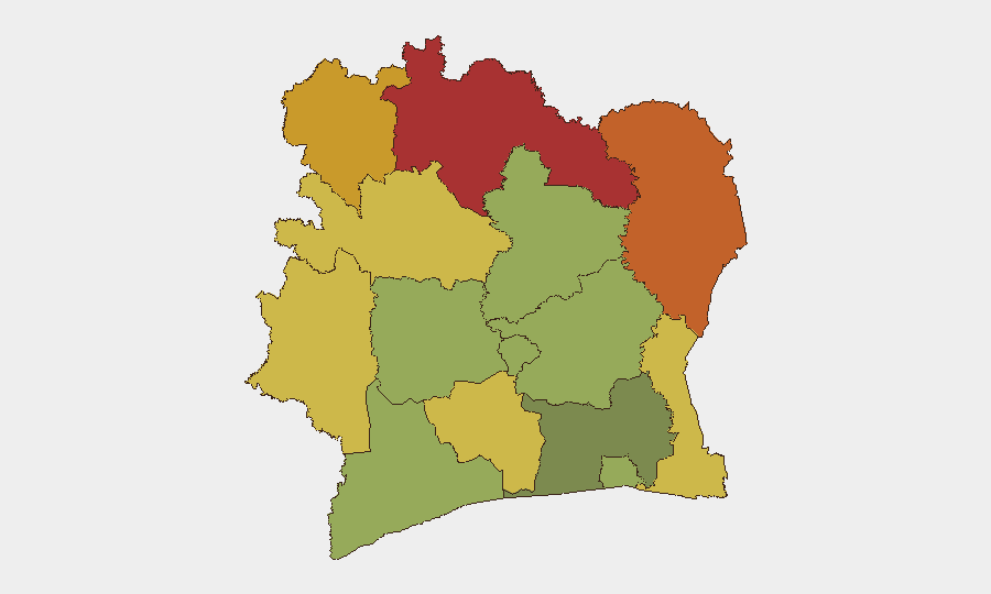
Situation Summary
Ivory Coast remains stable with a composite threat score of 20 globally. Open-source monitoring over the last 24–48 hours has not surfaced verifiable, time-bounded security incidents—major crime, civil unrest, infrastructure failure, or political instability—in any district. Sub-national risk remains concentrated in the northern savanna and forest zones (Savanes, Zanzan, Denguélé districts), where historical armed-group activity and cross-border trafficking create persistent exposure. The security environment shows no material deterioration in the reporting window.
Key Developments
No specific security incidents meeting 24–48 hour recency criteria are reliably documented in accessible open-source channels. Web and X/Twitter searches for protest, violence, crime, police action, infrastructure failure, or cross-border activity in Côte d'Ivoire in this window return World Cup sports content and older historical references, but no new, time-bounded security events.
*Note: GeoBit's event-signal database lists 11 signals dated 18–20 June (police actions, statements, investigations, rejections). However, these require local-source corroboration and context to assess operational significance. Open web does not yet surface details confirming location, scale, or material impact.*
Recommended action: Direct liaison with official travel advisories (US State Department, UK FCDO, French Ministry of Foreign Affairs) and real-time monitoring of local Ivorian government, police, and civil-protection feeds via X and local news aggregators for any breaking developments.
Highest-Risk Areas
Northern border districts—Savanes (78), Zanzan (75), and Denguélé (72)—carry the highest composite risk due to porous cross-border zones with Mali, Burkina Faso, and Guinea; persistent small-scale armed-group presence; trafficking networks; and limited state security capacity. Comoé and Montagnes (70, 68) mirror these vulnerabilities. Risk decreases sharply in the south and central regions (Abidjan at 45), where state authority and economic density are strongest. Personnel and assets in the north should assume elevated exposure to armed criminality, kidnapping, and exploitation by non-state actors, while southern urban centers carry lower but persistent conventional crime and civil-unrest risk.
How GeoBit Would Assist
Security teams should deploy AOI (Area-of-Interest) Monitoring & Early Warning on the five highest-risk northern districts to receive automated alerts when new threats emerge. Multi-language OSINT (X/Twitter, Telegram, local news feeds) and entity extraction will flag official statements, police actions, and community reports in real time. Routing & Network Analysis can generate alternative transport corridors and safe corridors if major roads or checkpoints become compromised. Periodic Conflict & Military mapping and Network & Actor Analysis will track armed-group movements and trafficking hubs.
7-Day Outlook
No acute triggering events are visible in the near term. Risk trajectory remains stable, with seasonal exposure in the north to cross-border incursions and trafficking activity. Monitor international travel advisories and local official channels for any changes; escalation would most likely originate in Savanes or Zanzan districts and would surface first on local government and security feeds before spreading to international media.
Highest-Risk Areas — Ranked
| # | State / Region | Risk |
|---|---|---|
| 1 | Savanes District | 78 |
| 2 | Zanzan District | 75 |
| 3 | Denguélé District | 72 |
| 4 | Comoé District | 70 |
| 5 | Montagnes District | 68 |
| 6 | Woroba District | 65 |
| 7 | Gôh-Djiboua District | 60 |
| 8 | Sassandra-Marahoué District | 58 |
| 9 | Vallée du Bandama District | 55 |
| 10 | Bas-Sassandra District | 52 |
| 11 | Lacs District | 48 |
| 12 | Abidjan | 45 |
Sources
Previous Daily Briefs
A new Ivory Coast brief is written every day — each with its own risk map and downloadable CSV. Here's the last week; use the calendar to go further back.
📅 Browse every day by calendar →
Highlighted days have a brief. Tap a day for that day's map & analysis, or “csv” for that day's dataset ($5).