Situation Summary
Lebanon remains in a protracted state of armed conflict, with Israeli and Hezbollah forces conducting sustained cross-border military operations across southern border zones. The overall threat environment is driven primarily by military strikes, with 237 tracked events elevating Lebanon to #13 globally on the composite threat ranking (87.5). Humanitarian conditions are deteriorating: healthcare infrastructure has absorbed 158 documented attacks since 2 March, with three hospitals and 41 primary care centres closed or non-functional, and displacement orders continue to force civilian movement in southern and central governorates. The trajectory remains high-risk with no ceasefire consensus and active conventional military exchange across the Blue Line.
Key Developments
- Southern Lebanon border zone (2026-06-01 to 04) – UNIFIL documented 1,296 Israeli projectile trajectories and 64 attributed to Hezbollah since Friday; heavy cross-border artillery and rocket fire ongoing with no de-escalation signal, creating acute risk for civilians and transit movements near the border.
- Nabatieh and South Governorates (2026-06-02 to 04) – Two paramedics affiliated with the Islamic Health Committee killed in airstrikes on emergency services; six southern hospitals have not resumed maternity services, degrading obstetric care capacity and increasing vulnerability for pregnant women in conflict zones.
- Southern towns and villages (2026-06-01 to 04) – Lebanese authorities renewed displacement orders across multiple settlements in Nabatieh and South Governorates, forcing additional civilian exodus and complicating access to food and medical care for vulnerable populations.
- National health infrastructure (cumulative, 2 March – 4 June) – WHO documented 158 attacks on healthcare facilities resulting in 108 deaths and 249 injuries; three hospitals and 41 primary health centres non-operational, reducing medical support capacity nationwide.
- Diplomatic and military signalling (2026-06-02 to 04) – Israeli and Lebanese forces exchanged public statements and conventional military actions; US reaffirmed Level 4 travel advisory; France issued appeal; Iran engaged in unconventional violence signal—indicating sustained state and non-state actor involvement with no clear de-escalation pathway.
- Humanitarian funding gap (cumulative) – UN emergency appeal of $308 million is only 40% funded, despite provision of 8.4 million meals, 4,300+ prenatal consultations, and 585 hospital admissions; resource shortfall signals sustained instability.
- UNIFIL area of operations (South Lebanon, Blue Line) – Peacekeeping force reports extensive military activity across area of operations, reflecting persistent risk of airstrikes, artillery, and rocket fire along key transport routes.
Highest-Risk Areas
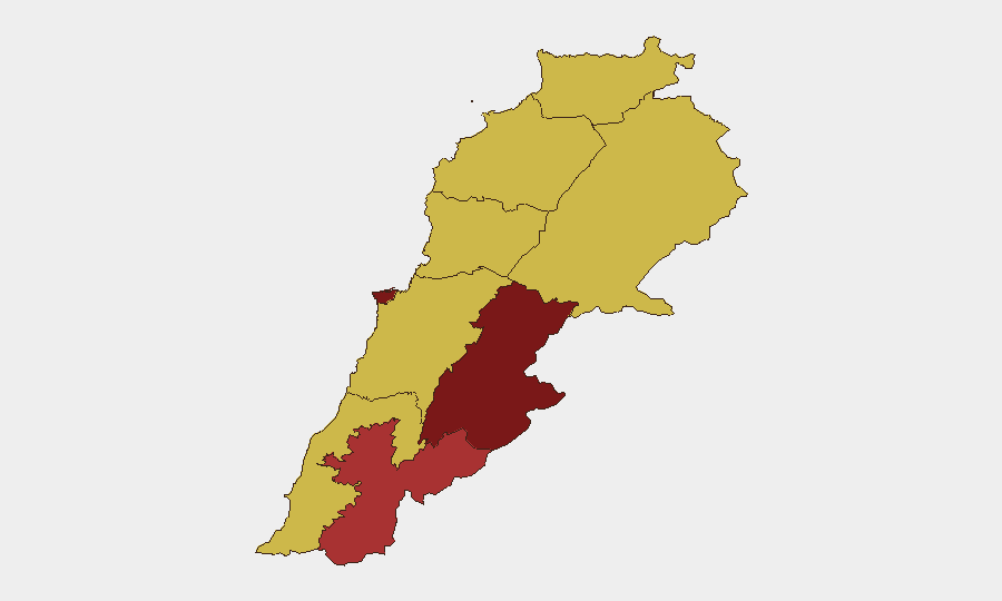
Beirut Governorate (91.2) dominates the national risk profile due to concentration of government, diplomatic, commercial, and financial infrastructure in an urban environment exposed to rocket and drone attacks. Beqaa Governorate (85.9) ranks second, reflecting proximity to Syrian border, Iranian supply lines, and Hezbollah operational footprint. The southern cluster—Nabatieh (78.1) and South Governorate (63.1)—sustains the highest kinetic risk due to direct Israeli-Hezbollah engagement, displacement cycles, and degraded healthcare. Mount Lebanon and northern governorates remain elevated (61–62) due to secondary effects of conflict (displacement, economic collapse, healthcare shortages) and logistical vulnerability.
How GeoBit Would Assist
Security teams should deploy AOI Monitoring & Early Warning on Beirut, Beqaa, and southern governorates for real-time alerting on military activity, strikes, and displacement announcements. Routing & Network Analysis enables identification of safe transit corridors and alternative journey planning around active conflict zones and healthcare closure zones. Conflict & Military force tracking and Satellite & Imagery analysis provide situational awareness of Israeli and Hezbollah positions, strike patterns, and humanitarian access chokepoints to inform duty-of-care assessments and evacuation triggers.
7-Day Outlook
Cross-border fire is likely to continue at current intensity absent a credible ceasefire mechanism; no diplomatic settlement signals are evident in recent public statements. Healthcare system strain will persist, elevating medical evacuation risk for personnel with serious injury or illness. Displacement orders may expand if strikes intensify, creating secondary movement risks and supply-chain disruption in central and northern regions.
Highest-Risk Areas — Ranked
| # | State / Region | Risk |
|---|---|---|
| 1 | Beirut Governorate | 91.2 |
| 2 | Beqaa Governorate | 85.9 |
| 3 | Nabatieh Governorate | 78.1 |
| 4 | South Governorate | 63.1 |
| 5 | Mount Lebanon Governorate | 62.2 |
| 6 | Baalbek-Hermel Governorate | 61.3 |
| 7 | North Governorate | 61.2 |
| 8 | Akkar Governorate | 61.2 |
| 9 | Keserwan-Jbeil Governorate | 61.2 |
Sources
Previous Daily Briefs
A new Lebanon brief is written every day — each with its own risk map and downloadable CSV. Here's the last week; use the calendar to go further back.
📅 Browse every day by calendar →
Highlighted days have a brief. Tap a day for that day's map & analysis, or “csv” for that day's dataset ($5).