Situation Summary
Liberia remains classified at mid-tier global risk (rank 126) with a composite threat score of 7. No verified security incidents, civil unrest, or conflict events have been reported in the past 24–48 hours from open sources. The security environment is characterized by persistent sub-national instability in the northeast and east-central counties, but no acute incident activity is evident in the current reporting window.
Key Developments
- Diplomatic engagement (June 24, 2026). Liberia and the U.S. State of Maryland formalized a sister-state partnership agreement covering trade, investment, and institutional cooperation. This development does not indicate elevated security risk and reflects positive bilateral engagement.
- No new security or conflict incidents reported (last 48 hours). Open-source monitoring, social media feeds, and news aggregation have not surfaced corroborated reports of violence, protests, armed clashes, or civil unrest in any Liberian locality during this window.
*Note: The absence of reported incidents does not indicate zero risk; rather, it reflects the current reporting landscape. Persistent underlying vulnerabilities in Nimba, Lofa, and Grand Gedeh counties remain unchanged.*
Highest-Risk Areas
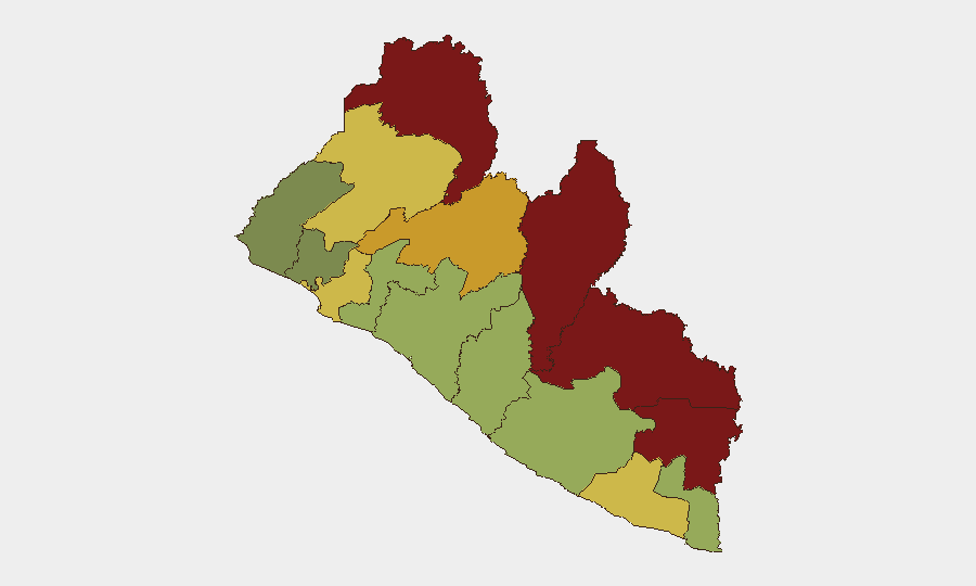
Nimba County (risk score 92), Lofa County (88), and Grand Gedeh County (85) comprise the highest-risk tier and drive the country's composite threat profile. These northeastern and east-central regions share borders with Guinea and Côte d'Ivoire, where transnational criminal networks, informal mining operations, and historical armed-group presence create persistent vulnerabilities. Montserrado County (score 64), home to Monrovia and the capital's commercial districts, maintains moderate-to-elevated risk due to urban criminality and informal-settlement instability. Risk in coastal and southern counties (Sinoe, Grand Bassa, Rivercess) is markedly lower but remains above negligible thresholds.
How GeoBit Would Assist
Area-of-Interest (AOI) Monitoring & Early Warning with persistent watch on Nimba, Lofa, and Grand Gedeh counties would detect emerging conflict signals, criminal activity, or civil unrest before they escalate to broader security incidents. OSINT fusion—combining X/Twitter, Telegram, local-language social channels, and news feeds—provides real-time sentiment and actor-network visibility across high-risk zones. GIS & Spatial Analysis and alternative route/journey planning support duty-of-care teams in identifying safe movement corridors for personnel and assets in Montserrado and surrounding counties, with dynamic re-routing based on incident location data.
7-Day Outlook
No acute security deterioration is forecast for the coming week based on available indicators. Sub-national risk in the northeast is expected to remain stable at elevated baseline levels; monitor for seasonal patterns in cross-border smuggling and informal mining disputes, which typically intensify in dry-season months. Routine security practices (movement discipline, situational awareness in Monrovia, avoidance of high-risk counties) remain the standard operational posture.
GEOBIT THREAT RANKING: Liberia #126 globally | Composite score 7 | 5 tracked events
Next scheduled brief: 2026-06-26
Highest-Risk Areas — Ranked
| # | State / Region | Risk |
|---|---|---|
| 1 | Nimba County | 92 |
| 2 | Lofa County | 88 |
| 3 | Grand Gedeh County | 85 |
| 4 | River Gee County | 83 |
| 5 | Bong County | 72 |
| 6 | Gbarpolu County | 68 |
| 7 | Grand Kru County | 65 |
| 8 | Montserrado County | 64 |
| 9 | Rivercess County | 58 |
| 10 | Sinoe County | 55 |
| 11 | Margibi County | 52 |
| 12 | Grand Bassa County | 48 |
Sources
Previous Daily Briefs
A new Liberia brief is written every day — each with its own risk map and downloadable CSV. Here's the last week; use the calendar to go further back.
📅 Browse every day by calendar →
Highlighted days have a brief. Tap a day for that day's map & analysis, or “csv” for that day's dataset ($5).