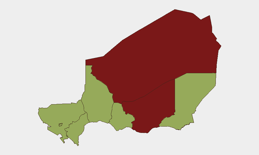
Situation Summary
Niger remains elevated on the global threat index (rank #15, composite score 76) amid concurrent pressures from armed militant activity in the north and east, political instability signaled by recent parliamentary and inter-agency tensions, and reported law-enforcement actions against media. The past 48 hours have generated seven tracked events spanning military operations, public statements, and state actions, suggesting a fluid and multi-vector risk environment. Agadez and Zinder regions—both scored 83.1—remain the primary concern zones; southern and central regions show moderate but persistent risk.
Key Developments
- 2026-06-13, location unspecified: Conventional military force engagement involving Nigerian armed forces and a male-identified individual or actor recorded in event stream; specific operational details and casualties remain unclear from available signals.
- 2026-06-12, nationwide: Nigerian authorities arrested or detained at least one media representative; concurrent public statements from state actors suggest possible tensions between government and press freedom.
- 2026-06-12, nationwide: Criminal-related threat issued by or involving Nigerian actors; insufficient detail in current signal to assess target or severity.
- 2026-06-11–12, nationwide: Series of public statements, demands from Senate, and inter-agency communications recorded; indicates domestic political friction between legislative and executive branches or security apparatus.
- 2026-06-11, nationwide: Nigeria issued threat and public statement regarding Niger; cross-border posturing or diplomatic friction cannot be ruled out.
- 2026-06-12, nationwide: Internal government disapproval signal between Nigerian agencies; suggests possible coordination breakdown or policy disagreement at state level.
- 2026-06-12, nationwide: Public statement directed at a company; context unclear but may relate to sanctions, extraction, or service-provision disputes.
Highest-Risk Areas
Agadez and Zinder regions (83.1 each) drive Niger's threat profile; both are known corridors for transnational militant activity, human smuggling, and ungoverned space exploitation. Diffa, Tillabéri, Tahoua, Maradi, and Dosso (53.1 each) represent secondary rings of risk, consistent with historical jihadist presence and bandit activity along borders with Nigeria, Mali, and Burkina Faso. Niamey (53.1), the capital, carries political and security-apparatus risk given the current domestic tensions reflected in recent event signals. The concentration of threat in the north and east, combined with political friction at center, suggests a bifurcated risk landscape: external militant pressure and internal state fragility.
How GeoBit Would Assist
Security teams should deploy AOI Monitoring & Early Warning on Agadez, Zinder, and Diffa regions to receive near-real-time alerting on militant movement, checkpoints, and cross-border activity. Intel Sweep (multi-language OSINT, X/Twitter & Telegram feeds, and entity extraction) would track parliamentary statements, state media releases, and armed-group communications to clarify intent and likely follow-on actions. Battle Mapping and Conflict Intelligence would establish baseline force posture and operational tempo in high-risk zones, enabling duty-of-care teams to refine travel restrictions and personnel positioning.
7-Day Outlook
Political tensions evident in recent parliamentary and inter-agency communications may escalate or consolidate depending on the nature of the demand(s) issued by Senate. Militant activity in the north is expected to remain at current operational tempo, with seasonal pressure likely on transport corridors. Corporate and NGO presence in secondary-risk regions should anticipate potential checkpoints, movement restrictions, or access denial if state-level instability deepens.
Highest-Risk Areas — Ranked
| # | State / Region | Risk |
|---|---|---|
| 1 | Agadez Region | 83.1 |
| 2 | Zinder Region | 83.1 |
| 3 | Diffa Region | 53.1 |
| 4 | Tillabéri Region | 53.1 |
| 5 | Niamey | 53.1 |
| 6 | Tahoua Region | 53.1 |
| 7 | Dosso Region | 53.1 |
| 8 | Maradi Region | 53.1 |
Sources
Previous Daily Briefs
A new Niger brief is written every day — each with its own risk map and downloadable CSV. Here's the last week; use the calendar to go further back.
📅 Browse every day by calendar →
Highlighted days have a brief. Tap a day for that day's map & analysis, or “csv” for that day's dataset ($5).