Situation Summary
Nigeria remains the third-highest composite threat environment globally, driven primarily by active insurgency, kidnap-for-ransom networks, and banditry across the northwest, north-central, and northeast regions. The security environment shows concurrent tactical wins (military hostage rescues, bandit-camp clearances) and sustained operational pressure on transportation corridors and rural communities. Political friction between federal security leadership and northern state actors, combined with civil-society mobilization around insecurity grievances, is creating secondary risk of nationwide disruption around Democracy Day (mid-June).
Key Developments
- Lokoja–Abuja highway corridor, Kogi State (11 June 2026). A bandit–police clash near Jamata resulted in at least four confirmed deaths and several injured; gunfire disrupted traffic and forced motorists to shelter in place, indicating sustained corridor vulnerability.
- Kogi State rural communities, Kabba–Bunu axis (11 June 2026). Bandits engaged security forces and vigilantes in a prolonged firefight; residents were displaced and casualties reported on both sides.
- Plateau State, Jos South–Barkin Ladi area (10–11 June 2026). Military foiled an attempted abduction of a pastor and spouse; suspected kidnappers were engaged, the couple rescued unharmed, and weapons recovered.
- Southern Kaduna–Plateau forest corridors (10–11 June 2026). Armed forces disrupted several kidnap attempts and freed dozens of abductees during clearance operations against bandit camps and organized kidnap gangs.
- Mandara Mountains, southern Borno State (weekend, acknowledged 11 June 2026). A joint military operation freed approximately 360–428 hostages held by a Boko Haram/JAS faction; follow-on operations ongoing in the Cameroon border area.
- Abuja civil-society briefing (11 June 2026). The #EndBadGovernance Movement and allied groups called for a 48-hour nationwide strike and protests over kidnappings and insecurity, specifically demanding scrutiny of federal and state "security votes," raising risk of demonstrations and associated disruption.
- National political-security messaging (10–11 June 2026). A prominent Sokoto State lawmaker publicly criticized federal security chiefs and flagged escalating northwest banditry, amplifying tensions between federal leadership and northern political elites.
- Multi-state incident aggregation (11 June 2026). A security-tracker compilation documented 11 incidents within 24 hours, including kidnappings of local politicians in Kebbi, abduction of an army general and spouse in Katsina, and multiple ransom kidnappings and rescues across the northwest and north-central regions.
Highest-Risk Areas
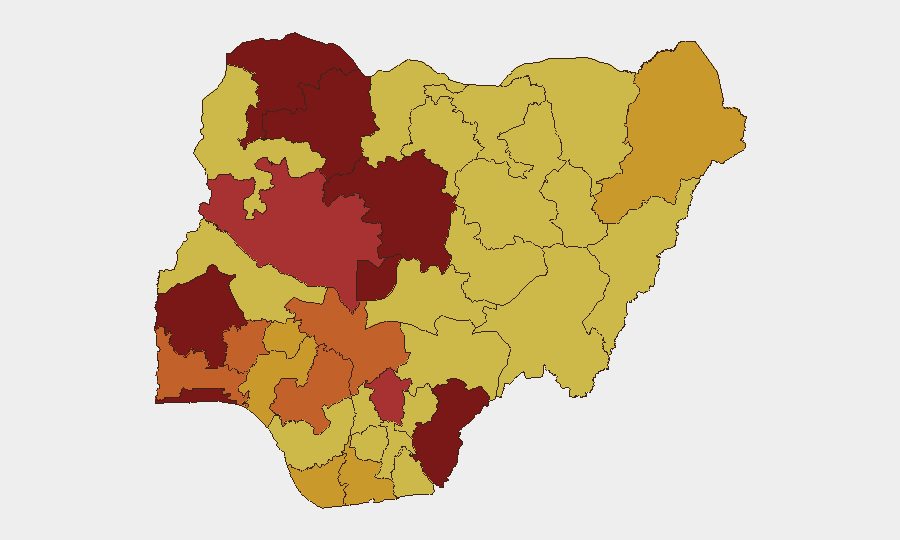
Lagos (100), Oyo (94.2), Sokoto (91.8), Kaduna (85.5), and the Federal Capital Territory (84.5) comprise the top-tier risk cluster, reflecting composite exposure to insurgency, kidnapping, banditry, and political instability. Sokoto and Kaduna—both northwestern states—are primary drivers of kidnap-for-ransom and bandit activity; Kaduna additionally sits astride key north-south corridors and hosts critical military and political assets. Lagos and Oyo's elevated risk reflects urban-crime, governance, and inter-communal tension dynamics distinct from the northern banditry profile. The Lokoja–Abuja highway in Kogi (rank 11, not in top 10) has demonstrated acute recent tactical vulnerability despite a lower composite score, signaling that established highway corridors remain persistent flashpoints.
How GeoBit Would Assist
Real-time AOI Monitoring & Early Warning with persistent corridor and state-level watch would flag incidents on priority routes (Lokoja–Abuja, Kaduna–Katsina) before they escalate. Intel Sweep and multi-language OSINT fusion would track civil-society mobilization signals, political messaging, and security-force briefings to forecast protest risk and secondary disruption windows. Routing & Network Analysis would enable security and duty-of-care teams to model alternative supply and personnel routes around active bandit and kidnap zones, with dynamic re-planning as incident patterns shift.
7-Day Outlook
Kidnap-for-ransom and banditry operations will likely continue at current tempo across the northwest, north-central, and northeast, with military clearance operations providing tactical relief but not systemic disruption to organized gangs. The 48-hour strike call and civil-society mobilization carry material risk of nationwide demonstrations and associated traffic disruption mid-week; federal and state security responses may further strain political cohesion. Corridor and rural community risk will remain elevated through the forecast window.
Highest-Risk Areas — Ranked
| # | State / Region | Risk |
|---|---|---|
| 1 | Lagos State | 100 |
| 2 | Oyo State | 94.2 |
| 3 | Sokoto State | 91.8 |
| 4 | Kaduna State | 85.5 |
| 5 | Federal Capital Territory | 84.5 |
| 6 | Zamfara State | 81.9 |
| 7 | Cross River State | 80.8 |
| 8 | Enugu State | 78.8 |
| 9 | Niger State | 77.5 |
| 10 | Edo State | 75.2 |
| 11 | Ogun State | 75.1 |
| 12 | Osun State | 73.6 |
Sources
Previous Daily Briefs
A new Nigeria brief is written every day — each with its own risk map and downloadable CSV. Here's the last week; use the calendar to go further back.
📅 Browse every day by calendar →
Highlighted days have a brief. Tap a day for that day's map & analysis, or “csv” for that day's dataset ($5).