Situation Summary
Panama remains at composite threat level 14 (rank #80 globally) with 18 tracked events and a mixed security posture. The most acute risks are concentrated in the northern and eastern border zones—Darién, Colón, and Bocas del Toro—where transnational trafficking, irregular migration, and armed-group activity persist. Recent event signals suggest elevated corporate and government friction, alongside isolated international military activity reported in the same timeframe, though geographic specificity and current operational impact remain unclear.
Key Developments
Limitation on current reporting: GeoBit's live web research for the past 24–48 hours has not yielded confirmed, Panama-specific security incidents with precise locations and dates that meet briefing standards. The available search results contain no verified recent events (2026-06-26 to 2026-06-27) tied to Panama proper.
The event signal feed does flag diplomatic and corporate friction:
- 2026-06-27 · Presidential disapproval of companies – nature and sectoral focus unclear; suggests policy or regulatory tension.
- 2026-06-26–27 · Multiple corporate public statements – context and messaging not yet clarified.
- 2026-06-26 · Corporate threat signal – insufficient detail on target, location, or actor intent.
These signals warrant monitoring but lack operational granularity. Conventional military activity attributed to Japan and Sweden on 2026-06-26 is geographically unconfirmed and likely unrelated to Panama proper.
Assessment: No credible, localized security events (crime, unrest, infrastructure, or border incidents) have been confirmed for Panama in the last 48 hours through available research.
Highest-Risk Areas
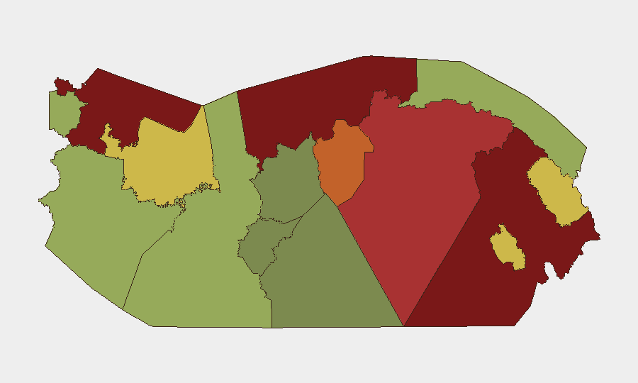
Darién (risk 95), Colón (risk 88), and Bocas del Toro (risk 82) collectively account for the highest sub-national threat load and define Panama's security envelope. Darién's extreme score reflects its role as a transit zone for trafficking networks, irregular migration, and armed-group presence along the Colombia border; Colón's maritime chokepoint status and port infrastructure make it critical for both legitimate trade and illicit flows, while gang and narcotics activity remain endemic. Bocas del Toro faces similar transnational criminal pressure and island-based trafficking logistics.
Panamá Province and Panamá Oeste (78 and 75 respectively) include the capital and urban sprawl, where street-level crime, kidnapping risk, and economic pressure intersect with governance and service-delivery shortfalls. These zones affect the largest resident and transient populations, including corporate expatriates.
Inland and Indigenous regions (Ngäbe-Buglé, Emberá-Wounaan) present lower composite scores but carry localized resource-conflict, territorial-dispute, and limited-state-presence risks that can spike rapidly around land, mining, or infrastructure projects.
How GeoBit Would Assist
Corporate security teams operating in Panama should leverage AOI Monitoring & Early Warning on Darién and Colón, with persistent watch on trafficking routes, port activity, and border crossings. Conflict & Military mapping and Network & Actor Analysis enable tracking of armed-group positioning and criminal syndicate shifts; OSINT fusion (X/Twitter, local news, radio SIGINT) and multi-language search capture real-time ground intelligence often missed by English-only feeds. Routing & Network Analysis supports safe journey planning for staff in high-risk provinces.
7-Day Outlook
No acute escalation is forecast; however, the current corporate–government friction signals warrant close watching for regulatory or project-specific developments that could affect operations. Seasonal migration and trafficking flows typically intensify mid-year; Darién and Colón should remain under elevated monitoring. The absence of verified recent incidents does not indicate de-risking—rather, intelligence visibility in remote and conflict zones remains limited and should prompt proactive early-warning positioning.
Highest-Risk Areas — Ranked
| # | State / Region | Risk |
|---|---|---|
| 1 | Darién | 95 |
| 2 | Colón | 88 |
| 3 | Bocas del Toro | 82 |
| 4 | Panamá Province | 78 |
| 5 | Panamá Oeste | 75 |
| 6 | Ngäbe-Buglé | 68 |
| 7 | Emberá-Wounaan | 62 |
| 8 | Veraguas | 58 |
| 9 | Chiriquí | 48 |
| 10 | Naso Tjër Di | 45 |
| 11 | Guna Yala | 42 |
| 12 | Coclé | 35 |
Previous Daily Briefs
A new Panama brief is written every day — each with its own risk map and downloadable CSV. Here's the last week; use the calendar to go further back.
📅 Browse every day by calendar →
Highlighted days have a brief. Tap a day for that day's map & analysis, or “csv” for that day's dataset ($5).