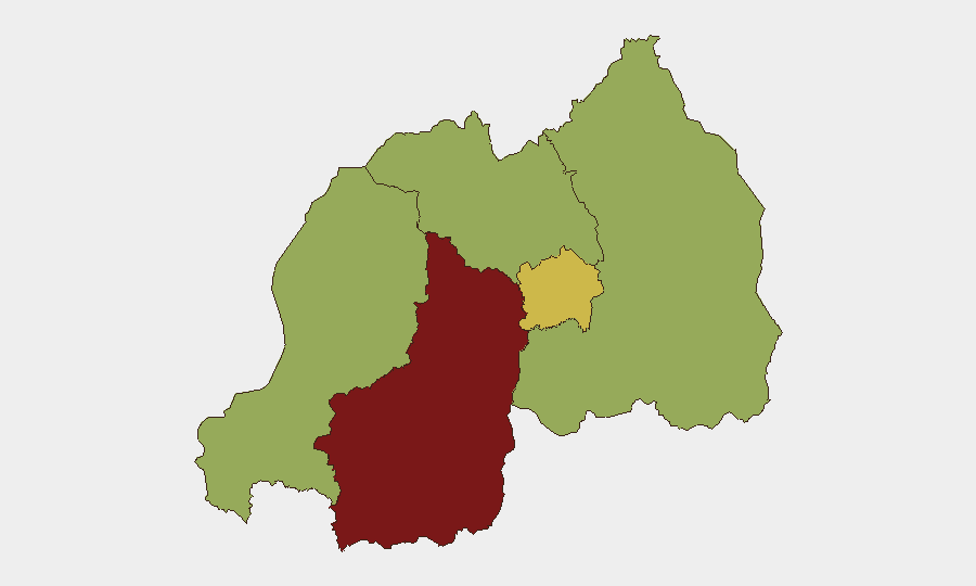
Situation Summary
Rwanda remains at elevated cross-border tension with the Democratic Republic of Congo (DRC), particularly over eastern DRC militia dynamics and competing diplomatic positions before the International Court of Justice. The Southern Province continues to carry the highest composite risk score (82.4), driven by proximity to unstable eastern DRC border zones and ongoing militia activity, while Kigali City presents moderate-to-elevated urban risk (61.8). Overall national threat ranking places Rwanda at #24 globally; trajectory is volatile but not yet escalatory toward direct armed conflict.
Key Developments
Unable to confirm specific developments from the last 24–48 hours. GeoBit's event signals show strong diplomatic and military-related activity (Congo disapprovals of Rwanda, conventional military force events, militia statements) dated 2026-06-27 through 2026-06-29, but the underlying incident details—specific locations, unit movements, casualty counts, or operational scope—are not sufficiently granular in the available signal set to brief corporate security teams with confidence. Live web research did not yield verifiable, dated reports of attacks, protests, crime, or infrastructure disruptions inside Rwanda proper within the 24–48-hour window.
Recommend: Security teams should cross-reference GeoBit event signals with their own real-time feeds (official Rwanda security advisories, embassy alerts, cross-border incident reporting from Goma/Bukavu) to validate whether the 27–29 June diplomatic and military events indicate operational changes affecting personnel or asset locations.
Highest-Risk Areas
Southern Province (82.4) dominates the risk landscape, reflecting sustained militia activity and armed group presence in eastern DRC's South Kivu and Tanganyika provinces immediately across the border, combined with historical infiltration routes and cross-border criminal networks. Kigali City (61.8) presents secondary risk concentrated in dense urban corridors, driven by protest potential, crime, and occasional spillover from national-level tensions. The remaining three provinces—Western, Northern, and Eastern—cluster at 52.4, indicating distributed but lower-intensity risk; Eastern Province's risk is notably tied to the DRC border and Burundi boundary zones. Strategic implication: Risk is geographically skewed toward the southwestern and eastern periphery; Kigali operations face primarily urban security discipline.
How GeoBit Would Assist
Security teams should deploy AOI (Area of Interest) Monitoring & Early Warning on Southern Province border crossings and known militia safe houses to detect force movements or infiltration before they affect corporate locations; pair with OSINT fusion (X/Twitter, Telegram, radio SIGINT) to track real-time militia and armed-group communications. Conflict & Military capabilities—including force-structure and weapons-capability tracking—enable tracking of DRC military and M23 posture changes that might presage cross-border spillover. GIS & Spatial Analysis and satellite/imagery analysis allow persistent border-zone surveillance and rapid damage assessment if incidents occur near supply chains or personnel hubs.
7-Day Outlook
Diplomatic tension over the ICJ case and DRC allegations of Rwandan support to eastern DRC militias will likely remain elevated through early July; no indicators suggest imminent major escalation, but militia activity and cross-border skirmishes in South Kivu/Tanganyika are expected to persist. Corporate assets and personnel in Southern Province and border-adjacent locations should maintain heightened situational awareness and contingency routing protocols.
Highest-Risk Areas — Ranked
| # | State / Region | Risk |
|---|---|---|
| 1 | Southern Province | 82.4 |
| 2 | Kigali City | 61.8 |
| 3 | Western Province | 52.4 |
| 4 | Northern Province | 52.4 |
| 5 | Eastern Province | 52.4 |
Sources
Previous Daily Briefs
A new Rwanda brief is written every day — each with its own risk map and downloadable CSV. Here's the last week; use the calendar to go further back.
📅 Browse every day by calendar →
Highlighted days have a brief. Tap a day for that day's map & analysis, or “csv” for that day's dataset ($5).