Situation Summary
Samoa remains in a stable security environment with no verified incidents of conflict, civil unrest, major crime, or infrastructure disruption in the last 24–48 hours. Public events and government activities have proceeded without disorder or security complications. The composite threat score remains low (5), and open-source monitoring shows routine governance and development announcements with no civil-unrest alerts or critical-infrastructure warnings.
Key Developments
- Tuamasaga district (Apia), 13–15 June 2026: Government development roadshows and cultural events in the capital and wider Upolu proceeded without protests, clashes, or noted crime or public-order issues; routine social-media announcements from government and ministry channels show no escalation.
- Apia & Upolu, 12–15 June 2026: Official channels report only minor, routine crime fluctuations typical of higher-population districts; no elevation of alert status has been warranted and near-term trajectory remains stable.
- Savai'i, 12–13 June 2026: Cultural events and government activities across the second main island proceeded without reported disorder, consistent with island-wide stability trend.
- National level, 13–15 June 2026: Three public statements involving the University of Samoa, New Zealand, and Samoan entities were registered in event signals; open-source monitoring has not corroborated any security or civil-unrest escalation stemming from these statements.
- Nationwide, 15 June 2026: No credible reports from news outlets, verified social-media accounts, or government alerts of new security incidents, travel advisories, or public-order concerns.
Highest-Risk Areas
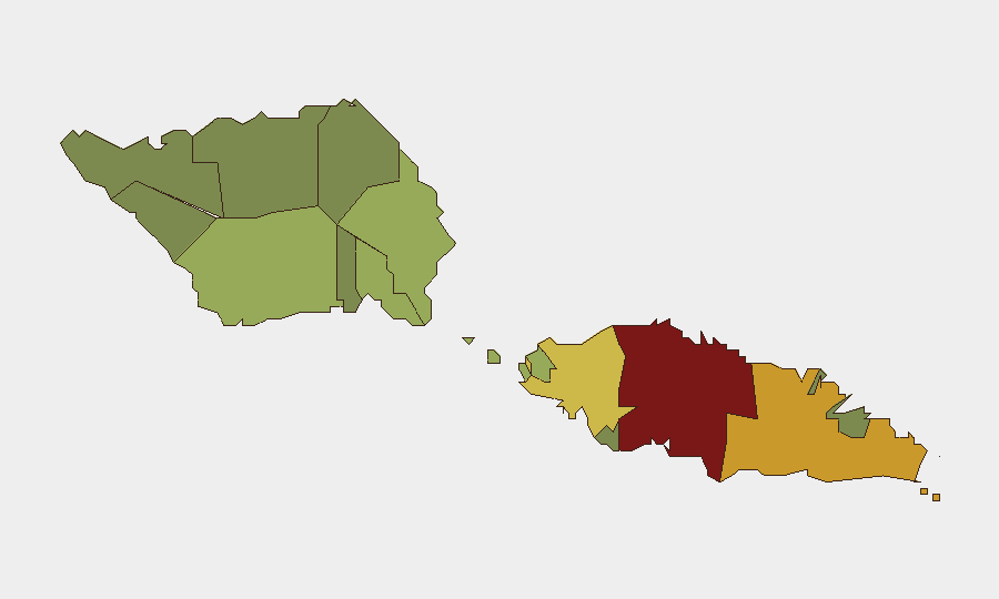
Tuamasaga (composite risk 85) remains the highest-risk district, driven by its role as the capital region, concentration of government, commerce, and population density in Apia. Ātua (risk 71) and Aʻana (risk 62) follow, likely reflecting secondary urban and commercial activity. These three districts account for the majority of Samoa's population and institutional activity; risk elevation in these areas would pose the greatest impact to corporate and expatriate presence. Risk scores in remaining districts decline with population and economic density, with Vaʻa-o-Fonoti (risk 23) posing minimal threat.
How GeoBit Would Assist
Teams with personnel or assets in Samoa should prioritize Area-of-Interest Monitoring & Early Warning focused on Tuamasaga (Apia) and Ātua to detect shifts in civil stability, labor disputes, or public-order incidents before they escalate. OSINT Fusion (X/Twitter, government social-media channels, and local news monitoring) combined with Sentiment & Temporal Analysis of official announcements and online discourse will provide early signal of political or social friction. Routing & Network Analysis and conflict/crime search capabilities can support rapid contingency planning should any of the three public statements escalate into street-level disruption.
7-Day Outlook
No indicators suggest material change to the current stable environment over the next 7 days. Monitor government communications and public sentiment around the three registered public statements, particularly any escalation involving universities or bilateral relations, but current absence of corroboration suggests low near-term risk. Routine security posture appropriate for a low-threat environment remains warranted.
Highest-Risk Areas — Ranked
| # | State / Region | Risk |
|---|---|---|
| 1 | Tuamasaga | 85 |
| 2 | Ātua | 71 |
| 3 | Aʻana | 62 |
| 4 | Aiga-i-le-Tai | 55 |
| 5 | Faʻasaleleaga | 48 |
| 6 | Palauli | 42 |
| 7 | Satupaʻitea | 38 |
| 8 | Gagaʻemauga | 35 |
| 9 | Gagaʻifomauga | 32 |
| 10 | Vaisigano | 28 |
| 11 | Vaʻa-o-Fonoti | 23 |
Sources
Previous Daily Briefs
A new Samoa brief is written every day — each with its own risk map and downloadable CSV. Here's the last week; use the calendar to go further back.
📅 Browse every day by calendar →
Highlighted days have a brief. Tap a day for that day's map & analysis, or “csv” for that day's dataset ($5).