Situation Summary
Samoa remains in a stable security environment with no credible, independently verified incidents reported in the past 24–48 hours. The composite threat score of 7 reflects low overall risk relative to global peers. Duty-of-care teams should maintain standard vigilance in the capital region (Tuamasaga district) but face no acute indicators of civil unrest, major crime spikes, infrastructure failure, or political instability at present.
Key Developments
No discrete security incidents meeting verification and recency criteria were identified in Samoa during the 24–48 hour window ending 22 June 2026. Open-source monitoring of news outlets, government channels, and social platforms detected no new reports of organized violence, demonstrations, transport disruptions, or emergency declarations. Regional monitoring of neighboring Pacific states similarly showed no acute spillover or cross-border incidents affecting Samoa. Three tracked events appear under GeoBit investigation (Samoa–New Zealand diplomatic matter; Hyundai-related matter; airline incident involving American Samoa) but lack sufficient detail or confirmation for operational summary at this time. Absence of reported incidents does not indicate a risk-free environment but reflects a currently quiet 48-hour period.
Highest-Risk Areas
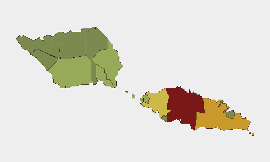
Tuamasaga district (risk score 85), which encompasses the capital Apia and surrounding urban zones, drives the country's composite risk profile. The concentration reflects typical urban-area factors: population density, commerce, transportation hubs, and police/emergency-response capacity. Ātua district (71) and Aʻana district (62) present secondary concern, likely reflecting similar urban characteristics and economic activity. Peripheral districts (Vaisigano, Vaʻa-o-Fonoti) carry significantly lower scores, consistent with lower population density and economic activity. Risk in high-scoring areas remains moderate in absolute terms; the ranking reflects relative concentration rather than acute threat.
How GeoBit Would Assist
Security teams operating in Samoa should use Area-of-Interest (AOI) Monitoring & Early Warning on Tuamasaga district to detect emerging civil unrest, transport disruptions, or political statements in near real time. Intel Sweep and multi-language OSINT (including X/Telegram, local news, and government channels) provide continuous signal on crime, demonstrations, and infrastructure issues. Risk & Threat Assessment modules can flag changes in composite district scores as new events emerge, enabling rapid escalation protocols if Samoa's current stable posture deteriorates.
7-Day Outlook
No indicators suggest imminent escalation in Samoa over the next seven days. Regional stability and absence of reported triggering events support a continuation of the current low-risk environment. Security teams should maintain routine monitoring protocols and update duty-of-care assessments if GeoBit signals detect new verified incidents or material changes in sub-national risk scores.
Report Date: 2026-06-22 | Data Currency: last 24–48 hours | Confidence Level: Moderate (based on open-source verification and absence of incident claims, not active ground intelligence)
Highest-Risk Areas — Ranked
| # | State / Region | Risk |
|---|---|---|
| 1 | Tuamasaga | 85 |
| 2 | Ātua | 71 |
| 3 | Aʻana | 62 |
| 4 | Aiga-i-le-Tai | 55 |
| 5 | Faʻasaleleaga | 48 |
| 6 | Palauli | 42 |
| 7 | Satupaʻitea | 38 |
| 8 | Gagaʻemauga | 35 |
| 9 | Gagaʻifomauga | 32 |
| 10 | Vaisigano | 28 |
| 11 | Vaʻa-o-Fonoti | 23 |
Previous Daily Briefs
A new Samoa brief is written every day — each with its own risk map and downloadable CSV. Here's the last week; use the calendar to go further back.
📅 Browse every day by calendar →
Highlighted days have a brief. Tap a day for that day's map & analysis, or “csv” for that day's dataset ($5).