Situation Summary
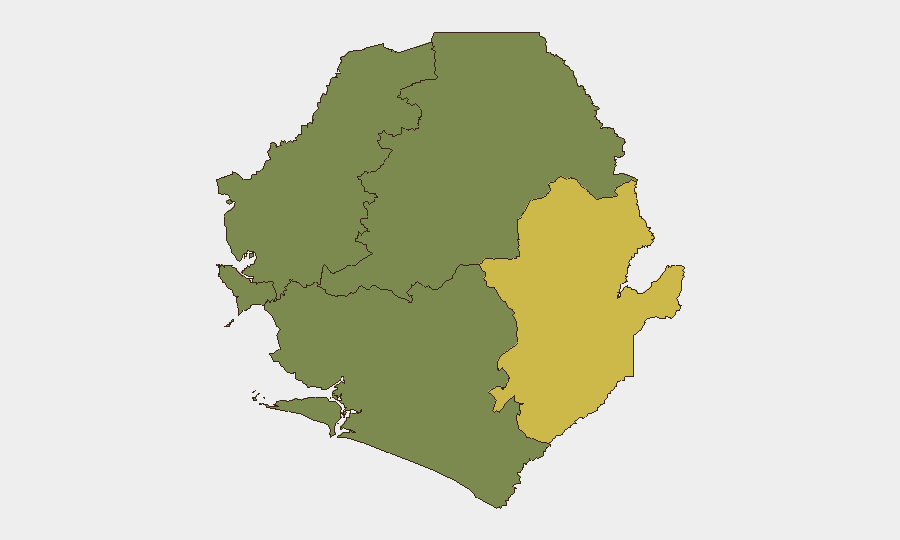
Sierra Leone remains a low-threat operating environment at the national level (composite threat score 6; ranked #119 globally). No major security incidents, armed conflict, civil unrest, or infrastructure disruptions were reported in the last 24–48 hours. The security picture is stable, with routine diplomatic and governance activity dominating recent coverage. Risk remains heavily concentrated in the Eastern Province, which drives the national threat profile.
Key Developments
Open-source reporting for 20–21 June 2026 does not confirm any acute security or civil unrest incidents meeting corporate security criteria (armed conflict, organized crime, protests with disorder, political instability, or major infrastructure failure). A 20 June journalists' workshop in Freetown on labor rights and fair pay was a scheduled advocacy event with no reported associated violence, arrests, or public disorder. An ongoing cholera situation continues to be monitored as a health risk, though it does not constitute a security incident. Recent diplomatic signals include routine multi-sectoral cooperation (e.g., Egypt–Sierra Leone pharmaceutical authority MoU on 20 June) and standard governance activity. No travel disruptions, airport closures, or major road blockages attributable to security events were reported. The absence of multi-source confirmation for new security-relevant incidents in the last 48 hours indicates no major developments requiring immediate escalation.
Highest-Risk Areas
The Eastern Province dominates risk exposure, with a composite score of 68—nearly double the Western Area (35) and substantially higher than the northern and southern provinces (all scored 0). The Eastern Province's elevation reflects its historical vulnerability to cross-border activity, limited state presence, and previous exposure to armed groups. The Western Area (including the capital, Freetown) carries moderate residual risk related to urban crime and population density but remains significantly lower-risk than the Eastern region. Northern, North West, and Southern provinces currently show minimal tracked threat indicators. Corporate teams with personnel or assets in the Eastern Province should maintain heightened awareness; those in Freetown and the Western Area face routine urban security considerations; northern and southern operations face correspondingly lower threat levels.
How GeoBit Would Assist
Teams managing duty-of-care for Sierra Leone should employ GeoBit's Intel Sweep and global event feeds to maintain real-time alerting on Eastern Province developments and cross-border activity from neighboring Guinea or Liberia. AOI Monitoring & Early Warning configured for the Eastern Province and key transport corridors would provide persistent watch capability and automated alerts if activity escalates. Risk & Threat Assessment and Network & Actor Analysis capabilities support vulnerability mapping for specific personnel or asset locations within high-risk areas, enabling targeted mitigation planning.
7-Day Outlook
No acute trajectory shifts are anticipated in the near term. Conditions in the Eastern Province warrant continued passive monitoring; no indicators suggest imminent escalation. Corporate security postures in Freetown and the Western Area should remain aligned with routine urban-security baselines. The cholera situation should be tracked as a health/operational consideration separate from security threat.
Highest-Risk Areas — Ranked
| # | State / Region | Risk |
|---|---|---|
| 1 | Eastern Province | 68 |
| 2 | Western Area | 35 |
| 3 | North West Province, Sierra Leone | 0 |
| 4 | Northern Province, Sierra Leone | 0 |
| 5 | Southern Province, Sierra Leone | 0 |
Sources
Previous Daily Briefs
A new Sierra Leone brief is written every day — each with its own risk map and downloadable CSV. Here's the last week; use the calendar to go further back.
📅 Browse every day by calendar →
Highlighted days have a brief. Tap a day for that day's map & analysis, or “csv” for that day's dataset ($5).